Abra del Acay
The highest point on Argentina's legendary Ruta 40, offering extreme altitude, rugged Andean landscapes, and a challenging off-road adventure.
Highlights
Must-see attractions

Social
From TikTok & Reddit
Best Time
Dry season, lowest river levels
Abra del Acay
Best Time
Dry season, lowest river levels
Highlights
Must-see attractions
The highest point on Argentina's legendary Ruta 40, offering extreme altitude, rugged Andean landscapes, and a challenging off-road adventure.
"A challenging but rewarding drive through breathtaking Andean scenery at nearly 5,000 meters."

🚗 4x4 is Essential
Don't attempt this route without a 4x4. Many travelers warn that standard cars will struggle with the rough terrain and river crossings.
🌡️ Pack for Extreme Cold
Even in warmer months, temperatures at 5,000m are freezing. Bring multiple warm layers, gloves, and a hat.
Quick Facts
Rating
4.8 · 429 reviews
Type
Observation Deck
Highlights
Discover the most iconic attractions and experiences
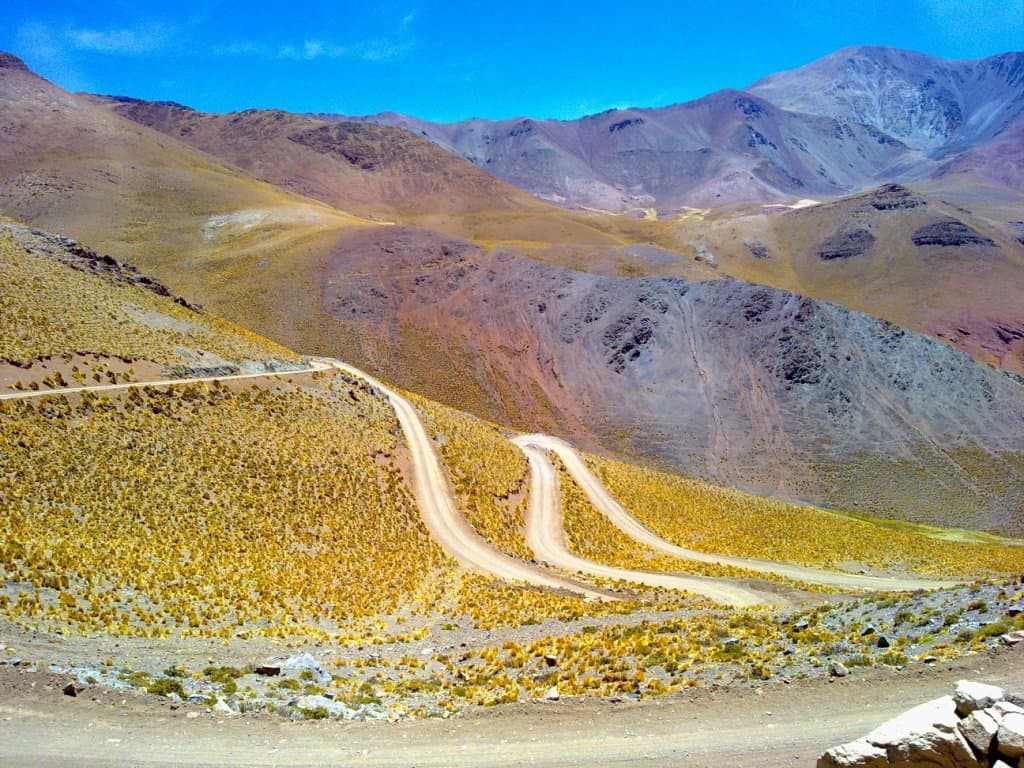
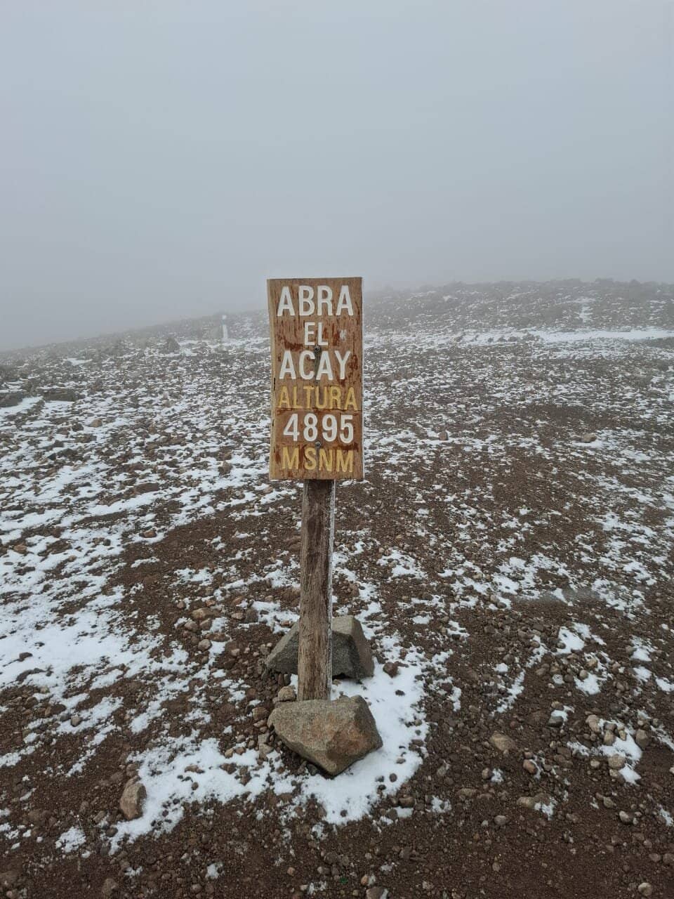
The Summit Marker
Highest point of Ruta 40
Stand at the iconic marker signifying the highest point of the legendary Ruta 40, nearly 5,000 meters above sea level.
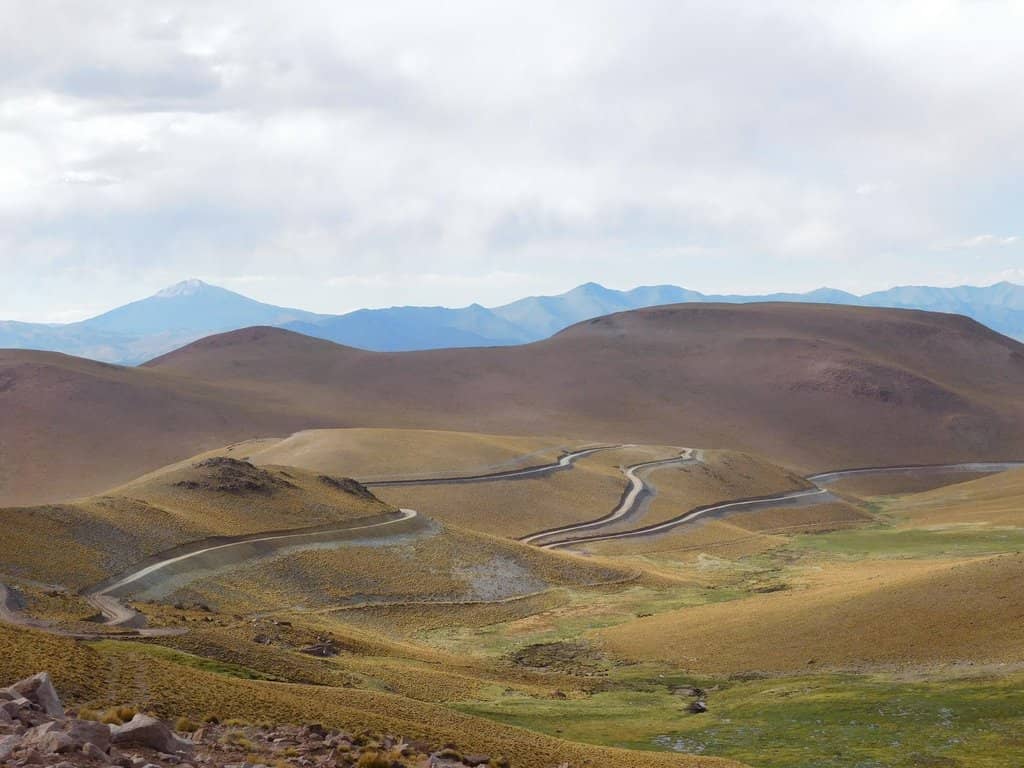
Dramatic Mountain Landscapes
Throughout the pass
Witness breathtaking, rugged mountain vistas, often dusted with snow and ice, offering unparalleled panoramic views.
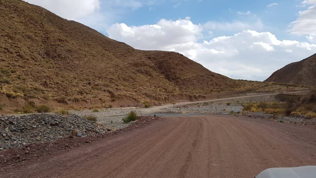
Challenging River Crossings
Various points along the route
Navigate thrilling river crossings that can test your vehicle and your nerve, adding to the adventure.
Plans like a pro.
Thinks like you
Planning Your Visit
Altitude & Weather Preparedness
Vehicle & Road Conditions
Best Times
Insider Tips
from TikTok, Instagram & Reddit
🚗 4x4 is Essential
Don't attempt this route without a 4x4. Many travelers warn that standard cars will struggle with the rough terrain and river crossings.
🌡️ Pack for Extreme Cold
Even in warmer months, temperatures at 5,000m are freezing. Bring multiple warm layers, gloves, and a hat.
💧 Carry Plenty of Water
There are very few services along this route. Ensure you have enough water and snacks for the entire journey.
⚠️ Inform Local Police
Register your travel plans with the police in La Poma or San Andres before setting off for safety.
Tips
from all over the internet
🚗 4x4 is Essential
Don't attempt this route without a 4x4. Many travelers warn that standard cars will struggle with the rough terrain and river crossings.
🌡️ Pack for Extreme Cold
Even in warmer months, temperatures at 5,000m are freezing. Bring multiple warm layers, gloves, and a hat.
💧 Carry Plenty of Water
There are very few services along this route. Ensure you have enough water and snacks for the entire journey.
⚠️ Inform Local Police
Register your travel plans with the police in La Poma or San Andres before setting off for safety.
⏳ Allow a Full Day
This is not a quick drive. Plan for a full day, and be prepared to potentially camp if conditions worsen.
What Travellers Say
Reviews Summary
Visitors consistently praise the breathtaking, rugged mountain scenery and the thrill of conquering the challenging Ruta 40 pass. However, many warn about the extreme altitude, unpredictable weather, and the necessity of a 4x4 vehicle due to the difficult road conditions and river crossings.
"Sept.25: we came from San Antonio de Los Cobres over the RN40 to Payogasta in approx 5 hours over an unpaved, bumpy gravel road.
There was very fierce wind & super cold; you needed to watch not to blown over. There was still snow & beautiful ice (peak) formations.
Getting there is incredibly exciting & it was difficult to get there @some points.
@times, the small rivers made the road disappear, especially after La Poma & we needed to cross 6 times.
The cliff is very close to the road & only one vehicle could pass along most of the route. It's almost impossible to turn if another car came from the other side; you needed to reverse to a spot where you could pass by another.
Keep in mind that this is a very high altitude point, close to 5.000 meters above sea level & the altitude is very noticeable."
Petra (Pitch)
"Beware! We crossed from san antonio going south to Cachi. We were not prepared for the drive but escaped without harm. Drive up from san anotonio was perfectly fine, narrow and but well maintained and easy to drive. Only put it in 4x4 as a precaution.
Drive down was different.
Road became increasingly worse as we went down. Issue was we were late in the day and had nothing but the truck. Review before stated correctly, road is GONE for a good km. Crossing the creek and then driving down the creek. Luckily we didn't bottom out. Roads themselves were washed a good bit, wouldn't take much for it to wash out a good portion.
Would I do it again? Probably but would at minimum have the entire day for the episode, be prepared to sleep on the road etc.
For less adventurous, Drive from san anotonio and turn back, well worth it."
Andrew Eck
"We went in October which is a good time due to the dry season (you'll cross the river 5 times and in October they are lowest). Our car was a Citroen C4 (without 4x4) and we didn't have problems. Register before going at the police station in La Poma or San Andres, start in the morning and bring enough water."
Vincent Labonte
What People Like
What People Dislike
Frequently Asked Questions
🚇 🗺️ Getting There
The most common route is via Ruta 40, connecting San Antonio de Los Cobres to Cachi. This section is largely unpaved and requires a 4x4 vehicle due to its challenging terrain, including rough gravel, river crossings, and potential washouts. Informing local police before departure is highly recommended. +1
Yes, but only with a suitable vehicle. A 4x4 is strongly advised due to the road's condition, which can be extremely rough, narrow, and prone to disappearing in riverbeds. Standard cars are not recommended.
The drive from San Antonio de Los Cobres to Cachi via Abra del Acay can take approximately 5 hours, depending on road conditions and your vehicle's capabilities. It's best to allocate a full day for this journey.
Traveling by bus is generally not feasible or advisable for the challenging sections of Ruta 40 through Abra del Acay. Travelers have reported that even large vehicles struggle, and police may advise against it for standard buses.
The road is often described as unpaved, bumpy, and very difficult, especially the descent towards Cachi. Expect narrow passages, fierce winds, snow, ice, and multiple river crossings that can wash away parts of the road. +1
🎫 🎫 Tickets & Entry
There are no specific entrance tickets required for Abra del Acay itself, as it's a natural mountain pass on a public road. However, it's crucial to register your travel plans with the local police in La Poma or San Andres before entering the area.
There are no official toll fees for driving through Abra del Acay. The primary costs will be related to your vehicle's fuel and potential wear and tear due to the challenging road conditions.
Abra del Acay is a natural mountain pass and is accessible year-round, 24 hours a day. However, travel is highly dependent on weather conditions, and it's advisable to travel during daylight hours for safety.
Yes, some tour operators offer expeditions to Abra del Acay, often as part of longer Ruta 40 journeys. These tours typically use specialized vehicles and experienced guides, which can be a safer option for those without a 4x4.
The dry season, from October to April, is generally considered the best time to visit as river levels are lower. However, even then, conditions can be unpredictable. July can offer beautiful ice formations but may present more challenging driving.
🎫 ⛰️ Onsite Experience
Abra del Acay reaches an altitude of approximately 4,850 to 5,000 meters (around 16,000 feet) above sea level, making it one of the highest points on the Ruta 40. +1
The main attractions are the breathtaking panoramic mountain views, the iconic summit marker of Ruta 40, the challenging off-road driving experience, and the dramatic natural landscapes, often featuring snow and ice. +1
Yes, it can be dangerous due to extreme altitude, unpredictable weather, fierce winds, and very challenging road conditions. Altitude sickness is a significant risk, and vehicle breakdowns can leave you stranded.
You need to dress in warm layers. Pack thermal underwear, fleece, a windproof and waterproof outer jacket, gloves, a warm hat, and sturdy footwear. The temperature can drop significantly, and the wind is often fierce.
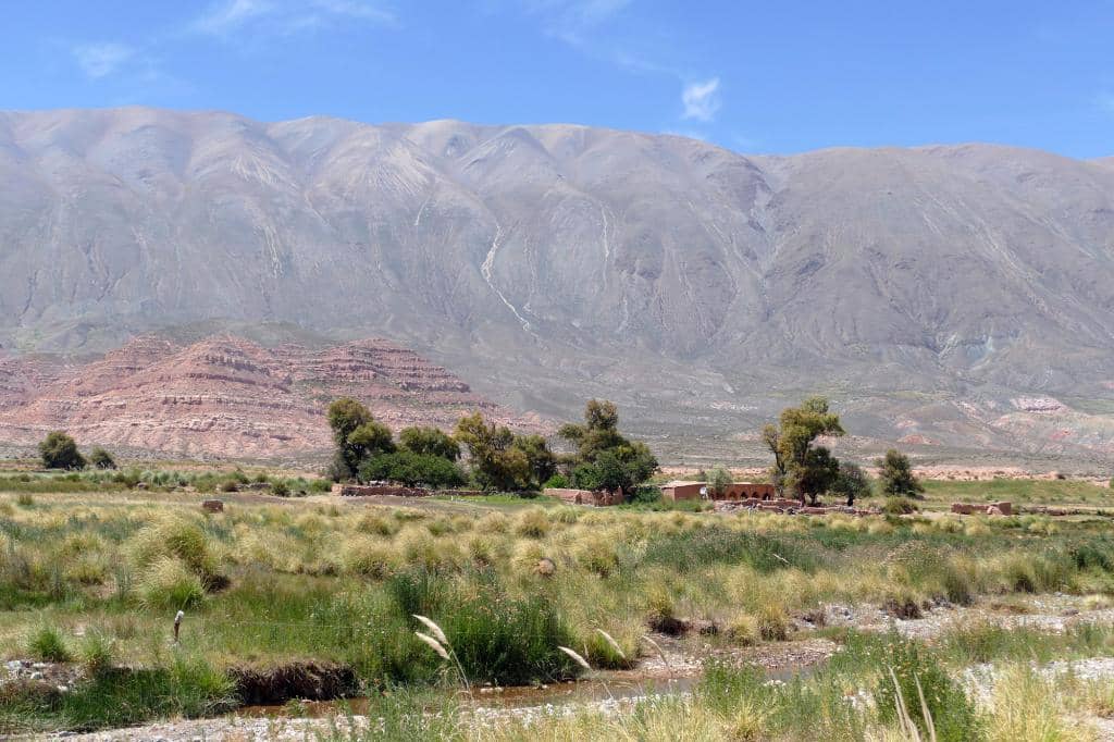
While wildlife sightings are not the primary focus, you might spot high-altitude birds of prey or other hardy animals adapted to the extreme environment. The focus is more on the dramatic geological and atmospheric conditions.
📸 📸 Photography
Capture the iconic summit marker, the vast, rugged mountain ranges, dramatic cloud formations, and the challenging river crossings. The play of light on snow and ice can also create stunning shots. +1
A wide-angle lens is great for capturing the expansive landscapes. Consider a telephoto lens for distant peaks. A sturdy tripod is useful for low-light conditions or capturing the vastness. Protect your gear from dust and extreme cold.
Yes, the cold can affect battery life, and your hands might be too cold to operate the camera comfortably. The thin air can also make it harder to hold steady. Take breaks and keep batteries warm.
Sunrise and sunset can offer dramatic lighting, but be mindful of the extreme cold and limited daylight hours. Midday can provide clear views, but the light can be harsh. Experiment with different times to see what works best.
The summit itself offers the most iconic views. Pull over safely at various points along the road to capture the sweeping vistas of the Andes. The river crossings also make for dramatic photographic subjects.


Social
from TikTok, Instagram & Reddit