
Quebrada de Escoipe Salta
A breathtaking scenic drive through dramatic, multi-colored mountain ridges and valleys, connecting Lerma to Calchaquí Valleys.

Highlights
Must-see attractions

Social
From TikTok & Reddit
Best Time
Clearer views, less fog
Quebrada de Escoipe Salta
Best Time
Clearer views, less fog
Highlights
Must-see attractions
A breathtaking scenic drive through dramatic, multi-colored mountain ridges and valleys, connecting Lerma to Calchaquí Valleys.
"Gorgeous ridges before you start hitting some crazy different landscapes!"

🚗 Drive Your Own Vehicle
Ideal for enjoying the viewpoints and stopping at your leisure. Renting a car offers the most flexibility.
☁️ Fog Can Roll In
Be prepared for reduced visibility, especially later in the day. Early morning is best for clear photos.

Quick Facts
Rating
4.8 · 82 reviews
Address
Highlights
Discover the most iconic attractions and experiences
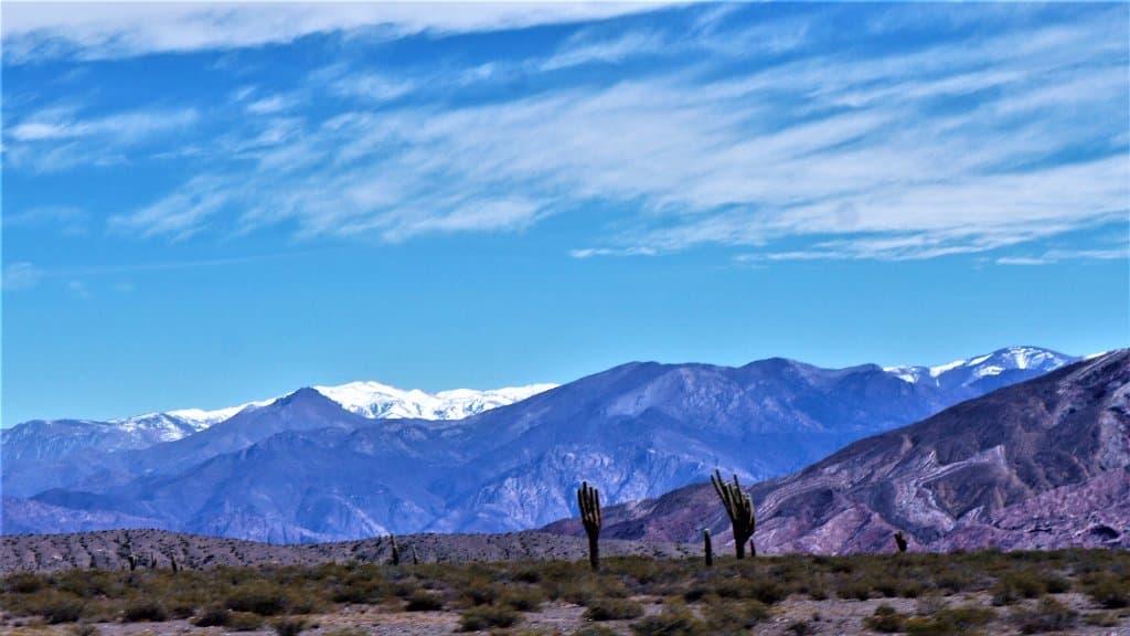
Cuesta del Obispo Views
Route 33
Zigzagging mountain road with breathtaking panoramas of colorful ridges and valleys. A must-see on the way to Cachi.

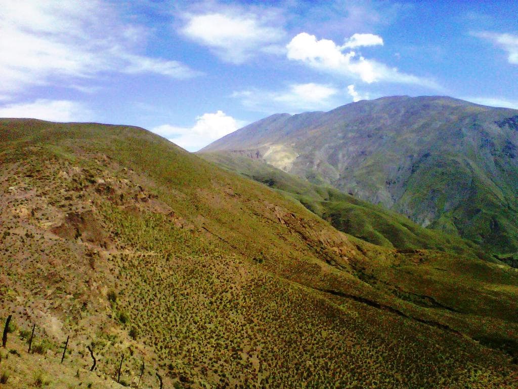
El Maray Mirador
Quebrada de Escoipe
Spectacular viewpoints showcasing multi-colored hills, local agriculture, and the chance to see condors soar.

Río Escoipe
Along Route 33
The river winds through the quebrada, adding to the lush, green landscape that defines this scenic route.
Plans like a pro.
Thinks like you
Planning Your Visit
Timing Your Scenic Drive
Embrace the Journey
Best Times
Insider Tips
from TikTok, Instagram & Reddit
🚗 Drive Your Own Vehicle
Ideal for enjoying the viewpoints and stopping at your leisure. Renting a car offers the most flexibility.
☁️ Fog Can Roll In
Be prepared for reduced visibility, especially later in the day. Early morning is best for clear photos.
📸 Capture the Colors
The 'gorgeous beginning part of our drive' offers stunning, colorful ridges. Early morning light is magical.
🚶♀️ Walk with Caution
If you enjoy walking, there are opportunities, but be mindful of ravines and potential fog.
Tips
from all over the internet
🚗 Drive Your Own Vehicle
Ideal for enjoying the viewpoints and stopping at your leisure. Renting a car offers the most flexibility.
☁️ Fog Can Roll In
Be prepared for reduced visibility, especially later in the day. Early morning is best for clear photos.
📸 Capture the Colors
The 'gorgeous beginning part of our drive' offers stunning, colorful ridges. Early morning light is magical.
🚶♀️ Walk with Caution
If you enjoy walking, there are opportunities, but be mindful of ravines and potential fog.
📍 Stop at Viewpoints
Numerous 'miradores' offer incredible photo opportunities of the multi-colored hills and valleys.
What Travellers Say
Reviews Summary
Visitors rave about the 'gorgeous ridges' and 'beautiful views' that mark the beginning of a dramatic landscape shift. It's primarily appreciated as a scenic drive, with many recommending an early morning visit for the clearest vistas. Some note it's more of a drive-by attraction than a place for extensive exploration.
"Gorgeous ridges before you start hitting some crazy different landscapes! Not really a place to get out and walk versus drive by."
Sammm Next Door
"Gorgeous beginning part of our drive.
Photo taken by @alejandroseveriniph (Instagram)"
Acrotravels Acroyoga
"Bellisimo...!!!!"
Violetas Campos
What People Like
What People Dislike
Frequently Asked Questions
🚇 🗺️ Getting There
To reach the Quebrada de Escoipe from Salta, take Route 68 south towards El Carril, then connect to Route 33. This route will lead you through the quebrada and towards the Cuesta del Obispo. Many travelers opt to drive their own vehicle for flexibility.
Yes, the Quebrada de Escoipe is a scenic and essential part of the route connecting Salta to Cachi. It's considered an 'excellent alternative' for reaching Cachi, offering unique landscapes along the way. +1
The Quebrada de Escoipe is located approximately 50-57 km from the city of Salta, depending on the specific point of entry into the quebrada. +1
Absolutely! Many visitors treat the drive through Quebrada de Escoipe and up the Cuesta del Obispo as a day trip from Salta, often continuing on to Cachi. It's a popular scenic drive.
The route through Quebrada de Escoipe is primarily Route 33, which includes the zig-zagging and steep sections of the Cuesta del Obispo. While generally paved, it's a mountain road with curves. +1
🎫 🎫 Tickets & Entry
There is no specific entrance fee for driving through the Quebrada de Escoipe itself, as it's a public route. However, if you plan to visit nearby national parks or attractions, separate fees may apply.
Quebrada de Escoipe is an open natural area accessible by road. There are no set operating hours, but it's best to visit during daylight hours for safety and visibility.
No advance booking is necessary for Quebrada de Escoipe as it is a scenic route. You can drive through it at your own pace.
Yes, many tour operators in Salta offer day trips that include the Quebrada de Escoipe and Cuesta del Obispo as part of their itinerary, often combined with visits to Cachi or Los Cardones National Park.
The most popular way to experience Quebrada de Escoipe is by driving through it, stopping at the various viewpoints to admire the landscapes.
📸 📸 Photography
Key photo spots include the viewpoints along the Cuesta del Obispo for panoramic vistas, El Maray for its colorful hills, and any pull-offs along Route 33 that offer unique perspectives of the winding road and river. +1
Early mornings are ideal for photography as the light is softer and the skies are often clearer. Clouds can roll in by the afternoon, affecting visibility and light.
A wide-angle lens is great for capturing the expansive landscapes. A telephoto lens can be useful for spotting condors or details in the distant mountains. Don't forget a sturdy tripod if you plan for sunrise/sunset shots.
The main challenge can be changing weather conditions, including fog and clouds that can obscure views. Also, the winding nature of the road means you'll need to be strategic about where you stop to take photos.
Drone regulations can vary. It's advisable to check current regulations with local authorities or the national park service if you plan to fly a drone, especially if you are near protected areas.


Social
from TikTok, Instagram & Reddit