
Mount Bartle Frere Trail
Queensland's tallest peak, offering a 'brutiful' hike through dense rainforest with challenging ascents and potential for stunning summit views.
Highlights
Must-see attractions

Social
From TikTok & Reddit
Best Time
Beat the heat and crowds
Mount Bartle Frere Trail
Best Time
Beat the heat and crowds
Highlights
Must-see attractions
Queensland's tallest peak, offering a 'brutiful' hike through dense rainforest with challenging ascents and potential for stunning summit views.
"Absolutely brutiful hike. Yes. Brutiful. It's so damn stunning yet so damn soul crushing."

💧 Hydration is Crucial
Carry at least 4-5L of water per person. Consider a water filter or purification tablets for refills .
🥾 Sturdy Footwear Essential
Hiking boots are recommended for grip and ankle support on steep, rocky terrain .

Highlights
Discover the most iconic attractions and experiences
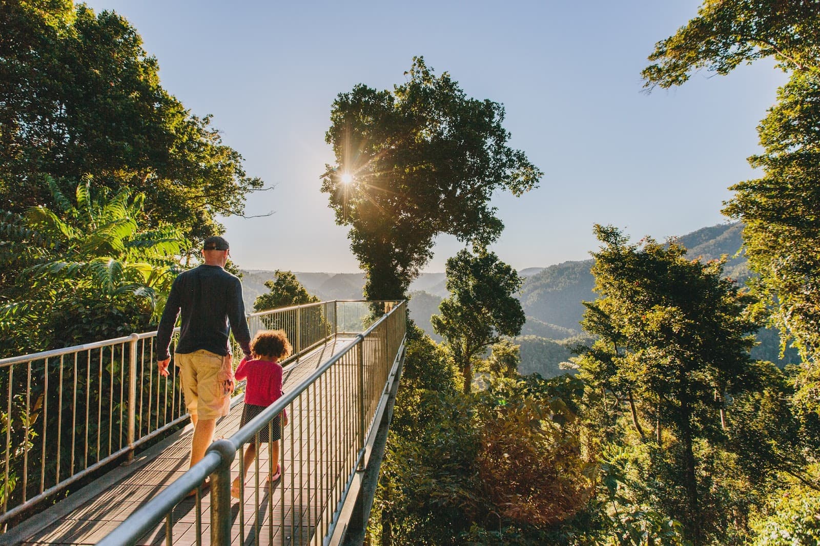
Summit Views
Mount Bartle Frere Summit
Breathtaking panoramic views from Queensland's highest point, but only on clear days (a rare 5-10% chance).
Boulder Field Scramble
Upper sections of the trail
A natural scrambling course over large boulders, adding an adventurous element to the ascent.

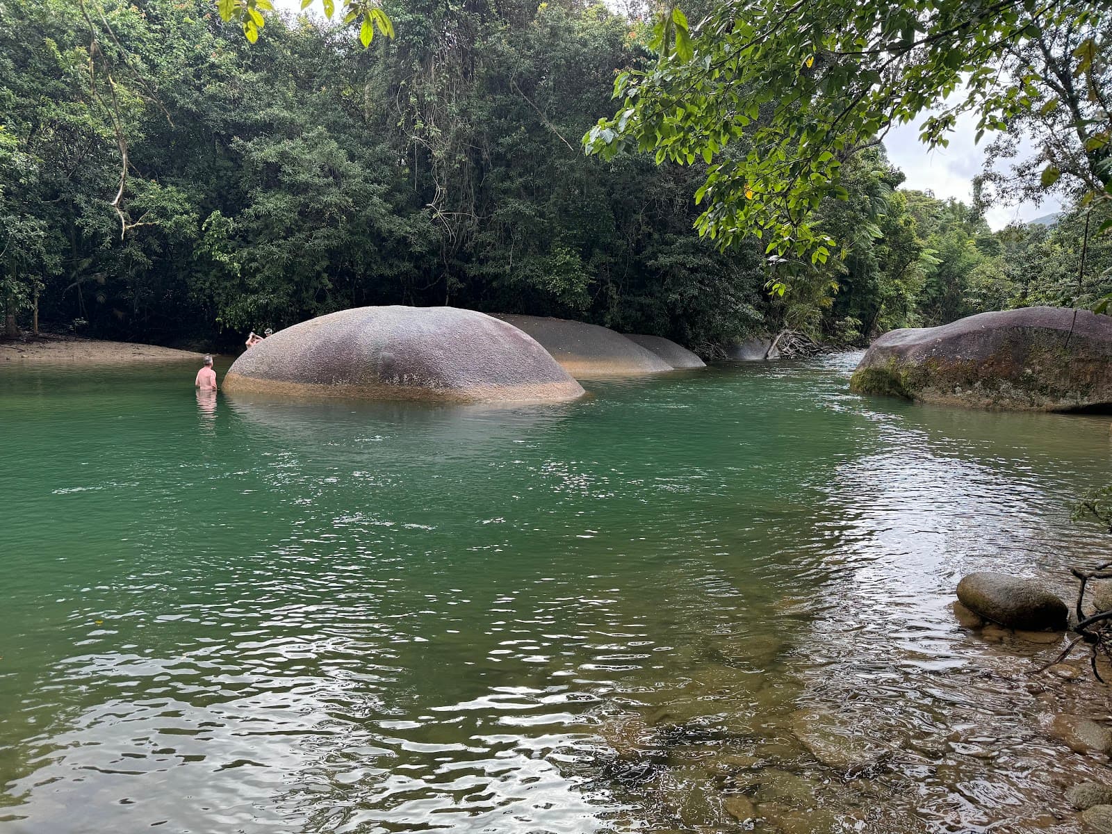
Josephine Falls
Trailhead area
A refreshing reward after the hike, perfect for a cooling dip to soothe tired muscles.
Unique Rainforest Flora
Upland rainforest
Discover rare species like Stockwellia quadrifida, a sister group to eucalypts.
Plans like a pro.
Thinks like you
Planning Your Visit
Prepare for a Brutal Beauty
Check Conditions & Pack Smart
Best Times
Insider Tips
from TikTok, Instagram & Reddit
💧 Hydration is Crucial
Carry at least 4-5L of water per person. Consider a water filter or purification tablets for refills.
🥾 Sturdy Footwear Essential
Hiking boots are recommended for grip and ankle support on steep, rocky terrain.
🐛 Leech Protection
Expect leeches, especially in wet conditions. Wear long socks and consider repellent.
⚠️ Check Park Alerts
Trail closures due to weather are possible. Always check the Queensland National Park website.
Tips
from all over the internet
💧 Hydration is Crucial
Carry at least 4-5L of water per person. Consider a water filter or purification tablets for refills.
🥾 Sturdy Footwear Essential
Hiking boots are recommended for grip and ankle support on steep, rocky terrain.
🐛 Leech Protection
Expect leeches, especially in wet conditions. Wear long socks and consider repellent.
⚠️ Check Park Alerts
Trail closures due to weather are possible. Always check the Queensland National Park website.
⏰ Start Early
To maximize daylight and avoid the worst heat, begin your hike at dawn.
📸 Capture the Views
If you're lucky enough to get a clear day, the summit views are unforgettable.
What Travellers Say
Reviews Summary
Hikers describe Mount Bartle Frere as a 'brutiful' experience – incredibly challenging yet stunningly beautiful. The steep ascent and demanding terrain are significant hurdles, but the potential for breathtaking summit views and the unique rainforest environment make it a rewarding endeavor for those well-prepared. Some visitors have encountered trail closures and challenging weather, emphasizing the need for thorough planning.
"Absolutely brutiful hike. Yes. Brutiful. It's so damn stunning yet so damn soul crushing 😂 the first 3kms are a literal walk in the park. Beautiful little creek crossings only a 300m accent. Then, the last 4.5km are a whopping 1,300m!! It's actually disgusting. But I can't recommend enough!
Please go well prepared (calculate your water. Minimum 4L I'd say. I've taken 5 both times for an overnight hike and it's been a good amount. Plus with life straw bottles etc. You're sweet on the way down or can refill from puddles etc.)
No easy task. But the views from the top (if you get a clear day) are breathtaking!"
Nathan Hughes
"We have done the summit trail last Monday. It started raining after the first hour of walking and we should have been wise and return back home. We thought being in middle of the rainforest, a little bit of rain was normal and that eventually it would have stopped (weather forecast said it was going to be clear).
Really hard work to get to km 6 (being the hardest part between 4 and 5) to find out that there was a signature of Closure until further notice due to area being dangerous after heavy winds and floods. Never got to the Helicopter platforms and camping area on km 7. Had to start our walk back down the mountain in order to camp at Big Rock. Nothing is advised in the Queensland National Park website (it says No alerts for this park) or in the board at the beginning of the trail. Disappointing not to be able to camp on top and see the sunrise."
Romina Saracho
"One of the most beautifully amazing and challenging hikes I have done. We were lucky enough to get a stunning view from the top... the rare 5-10% of the year apparently. Its a serious all over workout but the variety of terrain is really cool and the boulder field like a natural scrambling course. We did it comfortably in one day but we started early and are definitely of a very good above average fitness level. Parts of boulder field are exposed and not for nervous hikers. Lying on the rocks on the top felt like being on top of the world, magic. Went to helipad and the summit from josephine falls side. Jumping in the falls after arriving back to carpark hot sweaty and exhausted was the sweetest end to an unforgettable day. About 8hours roundtrip for a very fit and athletic person that can rockhop at height. Would advise to leave 10-12 hours in wetter conditions this hike would take so much longer. Dont take any risks. Always hike in your comfort level and be prepared for the unexpected."
Susan Keller
What People Like
What People Dislike
Frequently Asked Questions
🚇 🗺️ Getting There
The main trailhead is accessed via Josephine Falls Road, near Innisfail in Far North Queensland. It's about a 2-hour drive south of Cairns. The road can be rough in places, so a 4WD is recommended, though not always essential depending on conditions.
Yes, there is parking available at the Josephine Falls carpark, which is the starting point for the summit trail. It can get busy, especially on weekends and during peak season.
While Babinda is nearby and offers access to Wooroonooran National Park, the primary summit trail for Mount Bartle Frere starts from Josephine Falls. Babinda Boulders is a popular spot for swimming and exploring nearby.
The most common way is to drive. Renting a car in Cairns and heading south on the Bruce Highway is straightforward. The drive takes approximately 2 hours. Public transport options are very limited.
Currently, there are no dedicated shuttle services to the Mount Bartle Frere trailhead. Most visitors rely on private vehicles for access.
🎫 🎫 Tickets & Entry
No, there are no entry fees or tickets required to hike the Mount Bartle Frere summit trail. It's a free national park experience.
Wooroonooran National Park, which includes Mount Bartle Frere, is generally accessible year-round. However, specific trail conditions and potential closures due to weather should always be checked.
Camping is permitted at designated sites like Big Rock, but camping on the summit itself is not allowed. Hikers aiming for the summit often camp at Big Rock and ascend the next day.
While no specific permits are required for the summit trail, it's always advisable to check the Queensland National Parks website for any updated regulations or alerts, especially for overnight stays.
Camping at Big Rock is on a first-come, first-served basis. There are no booking facilities, so arriving early is recommended, especially during busy periods.
🎫 🥾 Onsite Experience
For very fit and experienced hikers, it can take around 8-10 hours roundtrip. Many people opt for an overnight hike, camping at Big Rock. Allow 10-12 hours in wetter conditions.
This is considered a very difficult and challenging hike. The ascent is steep, with sections of scrambling over boulders and potentially slippery terrain.
Wear sturdy hiking boots with good grip. Long pants and long-sleeved shirts are recommended to protect against leeches and scratches. Bring a rain jacket, as weather can change quickly.
Toilets are available at the Josephine Falls carpark. There are natural water sources along the trail, but it's essential to treat or filter all water before drinking.
You might encounter various rainforest birds, insects, and potentially tree kangaroos. Keep an eye out for the unique 'big blue earthworm' (Terriswalkeris terraereginae).
📸 📸 Photography
The summit offers incredible panoramic views on clear days. The rainforest itself, with its lush vegetation and unique flora like Stockwellia quadrifida,
provides stunning photographic subjects. The boulder fields also make for dramatic shots.
The views from the summit are spectacular, but they are highly dependent on weather. Many hikers find the challenging journey through the rainforest and the sense of accomplishment equally rewarding, even if the summit is clouded over.
A wide-angle lens is great for capturing the expansive views. A macro lens can be useful for photographing the unique rainforest flora and fauna. Ensure your gear is protected from rain and humidity.
Early morning light can be beautiful for capturing the rainforest's atmosphere. If you're aiming for summit views, clear mornings or late afternoons (if the weather permits) offer the best light.
Drone usage in national parks is generally restricted. It's essential to check the latest regulations from Queensland Parks and Wildlife Service before flying a drone in the area.
For Different Travelers
Tailored advice for your travel style
👨👩👧 Families with Kids
💰 Budget Travelers
💪 Fitness Enthusiasts
Deep Dives
In-depth insights and expert knowledge
The Challenge of the Summit Trail
The trail involves navigating through dense rainforest, with sections requiring scrambling over large boulders. This natural rock-climbing course adds an element of adventure but also increases the challenge. The unpredictable weather in the region means that rain is common, turning the trail into a slick and demanding obstacle course. Leeches are also a significant factor, particularly after rain, requiring constant vigilance and appropriate gear.
Given the intensity of the hike, many visitors opt for an overnight trip. Camping is permitted at designated sites like Big Rock, allowing hikers to break up the journey and attempt the summit the following day. This approach also provides an opportunity to witness a sunrise from the top, though clear summit views are rare, occurring only about 5-10% of the time.
Flora and Fauna Encounters
Keep an eye out for the elusive tree kangaroo, a creature that has been sighted by hikers on the trail.
However, the rainforest's abundance also means dealing with its inhabitants. Leeches are prevalent, especially during and after rainfall. Hikers are advised to wear long clothing and consider using leech repellent to minimize encounters. The sheer density of the rainforest and its humid conditions contribute to the unique environment where these species thrive.
Planning for Success: Water, Gear, and Safety
Footwear is critical. Sturdy hiking boots with excellent grip are essential for navigating the steep, often slippery, and rocky terrain. Many social media posts emphasize the need for good ankle support. Beyond boots, long pants and long-sleeved shirts are highly recommended to protect against leeches, scratches from dense vegetation, and the elements. A reliable rain jacket is a must, as weather can change rapidly and dramatically in the mountains.
Safety is non-negotiable. Always check the latest weather forecasts and park alerts from Queensland Parks and Wildlife Service before you go, as trail closures due to floods or high winds can occur without much notice.


Social
from TikTok, Instagram & Reddit