Kummenberg
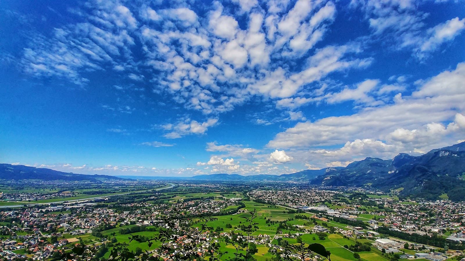
Kummenberg: A scenic mountain in Vorarlberg's Rhine Valley, offering breathtaking panoramic views and diverse hiking trails.

Highlights
Must-see attractions

Social
From TikTok & Reddit
Best Time
Crisp air, fewer crowds
Kummenberg
Best Time
Crisp air, fewer crowds
Highlights
Must-see attractions
Kummenberg: A scenic mountain in Vorarlberg's Rhine Valley, offering breathtaking panoramic views and diverse hiking trails.
"Beautiful hiking mountain with many trails and great views, reaching all the way to Lake Constance."

Wear Sturdy Footwear
Some trails are steep and narrow; good hiking boots are essential for grip and comfort. :athletic_shoe:
Check Weather Forecast
Visibility can vary greatly. Clear days offer the best panoramic views of Lake Constance. ☁️

Quick Facts
Rating
4.8 · 29 reviews
Type
Natural Feature
Highlights
Discover the most iconic attractions and experiences
Panoramic Summit Views
Summit area
Breathtaking 360-degree vistas of the Rhine Valley, reaching Lake Constance on clear days.
Gallusweg Trail
Ascent from Koblach
A scenic forest path offering a moderate climb with rewarding views as you ascend.

Kadel Quarry Viewpoint
Northwest descent
An impressive viewpoint overlooking a sheer 250m drop from the quarry wall.
Plans like a pro.
Thinks like you
Planning Your Visit
Best Views & Trail Tips
Getting to the Trailhead
Best Times
Insider Tips
from TikTok, Instagram & Reddit
Wear Sturdy Footwear
Some trails are steep and narrow; good hiking boots are essential for grip and comfort. :athletic_shoe:
Check Weather Forecast
Visibility can vary greatly. Clear days offer the best panoramic views of Lake Constance. ☁️
Bring Water & Snacks
There are no facilities on the mountain, so pack essentials for your hike. :water_wave:
Start from Koblach Church
The parking lot below the church is a common and convenient starting point for many trails. 🚗
Tips
from all over the internet
Wear Sturdy Footwear
Some trails are steep and narrow; good hiking boots are essential for grip and comfort. :athletic_shoe:
Check Weather Forecast
Visibility can vary greatly. Clear days offer the best panoramic views of Lake Constance. ☁️
Bring Water & Snacks
There are no facilities on the mountain, so pack essentials for your hike. :water_wave:
Start from Koblach Church
The parking lot below the church is a common and convenient starting point for many trails. 🚗
What Travellers Say
Reviews Summary
Visitors consistently praise Kummenberg for its stunning panoramic views, particularly the vistas reaching Lake Constance on clear days. The mountain offers a variety of hiking trails suitable for different fitness levels, with some steeper sections providing a good challenge. It's a popular spot for a rewarding hike in Vorarlberg's Rhine Valley.
"Beautiful hiking mountain with many trails and great views."
Helmut Aichberger
"A wonderful, scenic hiking area in Vorarlberg's Rhine Valley. In good weather, you can see all the way to Lake Constance."
Roger K
"The Kummenberg stands isolated in Vorarlberg's Rhine Valley, dividing it into the Lower and Upper Lands. It lies entirely within the municipality of Koblach and is ideal for a short hike:
The starting point is the parking lot below the church at 445 m. After a few meters on the old Kummastraße road, turn right into the forest, climbing the first 90 meters. Continue above the climbing garden on the Gallusweg trail down towards the shooting range. You reach it after 1.6 km (426 m). Briefly follow the path north, then turn right again onto a forest road up to the Udelberg. Before the motorway – which was literally blasted through the mountain in 1971 – the trail makes a 180-degree turn and ends. The unmarked trail continues west through the forest, connecting at "Krinna" (480 m) to the "Bösen Tritt" trail. This trail is quite steep and narrow, but always in the forest, towards the summit.
The rest area at 667 m is reached after 3.6 km. From there, there are stunning views towards the Unterland, all the way to Lake Constance and beyond. The wall created by the quarry behind the railing drops 250 m vertically! Then the trail heads northwest down the mountain again, gently at first, then steeply in places. After about 5 kilometers, you reach the forest road at the "Nellabürgle" – a large boulder – at 480 m. On the right, there is another viewing point at the Kadel quarry. After 6 kilometers, you return to the parking lot."
Werner Sommer
What People Like
What People Dislike
Frequently Asked Questions
🚇 🗺️ Getting There
The most common access point is the parking lot below the church in Koblach. From there, various hiking trails lead up the mountain. Driving is the most convenient way to reach the trailhead.
While direct public transport to the trailhead might be limited, you can take buses to Koblach and then walk to the starting point. Check local transport schedules for the most up-to-date information.
There is a parking lot available below the church in Koblach, which serves as a primary starting point for many hikers.
Many hikers begin by following the old Kummastraße road from the parking lot before turning into the forest. The Gallusweg trail is a popular ascent route.
Yes, you can drive to the base of the mountain and park near the church in Koblach, which is the main trailhead. The motorway was blasted through the mountain, but access to the hiking paths is from the valley floor.
🎫 🎫 Tickets & Entry
No, hiking Kummenberg is free of charge. It's a natural area open for public access.
Kummenberg is accessible year-round during daylight hours. There are no official opening or closing times for the hiking trails.
There is no entrance fee to hike or visit Kummenberg. Access to the trails is free for everyone.
While technically possible, hiking at night is not recommended due to safety concerns and lack of lighting on the trails. Stick to daylight hours for the best experience.
No permits are required for general hiking and visiting Kummenberg. It's a public natural space.
🎫 🥾 Onsite Experience
Hikes on Kummenberg range from moderate to steep. Some sections, like the 'Bösen Tritt' trail, are quite steep and narrow, offering a good challenge.
A typical hike to the summit and back can take anywhere from 2 to 4 hours, depending on your pace and the chosen route.
Expect stunning panoramic views of the Rhine Valley, the surrounding mountains, and on clear days, all the way to Lake Constance.
No, there are no facilities such as restrooms or cafes on the mountain itself. It's a natural hiking area, so come prepared.
While some trails are steep, families with older children who are accustomed to hiking can enjoy Kummenberg. Shorter, less strenuous routes are available.
📸 📸 Photography
The summit offers incredible panoramic shots. Also, the Kadel quarry viewpoint provides dramatic perspectives. Look for clear days for the best visibility towards Lake Constance.
Mornings often provide softer light and fewer crowds, while afternoons on clear days offer the best chance to see Lake Constance. Golden hour can also be beautiful.
Drone usage regulations can vary. It's advisable to check local drone laws and regulations before flying a drone in the area to ensure compliance.
A wide-angle lens is great for capturing the expansive views. A telephoto lens can be useful for details in the valley. A sturdy tripod can help with low-light conditions. :camerawithflash:
Don't miss the view towards Lake Constance from the summit, the sheer drop at the Kadel quarry, and the unique landscape shaped by the motorway construction.


Social
from TikTok, Instagram & Reddit