
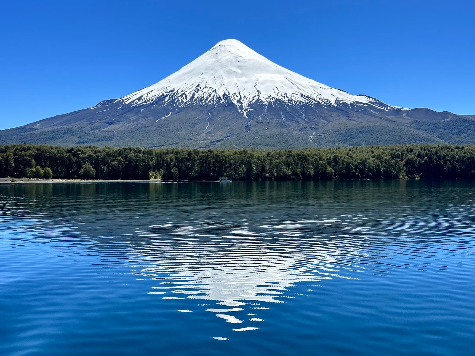
Desolation Trail
Hike through a unique volcanic landscape with stunning mountain views, culminating in a rewarding summit experience.

Highlights
Must-see attractions

Social
From TikTok & Reddit
Best Time
Fewer people, serene atmosphere
Desolation Trail
Best Time
Fewer people, serene atmosphere
Highlights
Must-see attractions
Hike through a unique volcanic landscape with stunning mountain views, culminating in a rewarding summit experience.
"Impressive view and not technical! A great trail for running with almost 1000m climb. "

🥾 Trekking Poles Recommended
The last 1.9 km are steep; poles greatly aid balance and reduce strain. :hiking_boot:
🚗 Free Parking Available
Easy access with any car, and parking is conveniently located at the trailhead. 🚗

Quick Facts
Rating
4.8 · 64 reviews
Type
National Park
Highlights
Discover the most iconic attractions and experiences
Volcanic Terrain Trail
The entire trail
Experience a unique landscape of sandy volcanic soil, offering a soft yet grippy surface for your hike.
Mirador Views
Mid-trail viewpoint
Enjoy breathtaking panoramic views of the surrounding mountains from this popular lookout point.

Old Ski Station Shelter
End of the trail
Discover a rustic wooden hut at the volcano's end, offering a unique shelter and a sense of accomplishment.
Plans like a pro.
Thinks like you
Planning Your Visit
Timing Your Visit to Avoid Crowds
Essential Gear for the Trail
Best Times
Insider Tips
from TikTok, Instagram & Reddit
🥾 Trekking Poles Recommended
The last 1.9 km are steep; poles greatly aid balance and reduce strain. :hiking_boot:
🚗 Free Parking Available
Easy access with any car, and parking is conveniently located at the trailhead. 🚗
⚠️ Watch for Mountain Bikers
While generally polite, be aware of mountain bikers sharing the trail. :mountain_biking:
💧 Water Sources
Water is available every few kilometers, especially in late October. :droplet:
Tips
from all over the internet
🥾 Trekking Poles Recommended
The last 1.9 km are steep; poles greatly aid balance and reduce strain. :hiking_boot:
🚗 Free Parking Available
Easy access with any car, and parking is conveniently located at the trailhead. 🚗
⚠️ Watch for Mountain Bikers
While generally polite, be aware of mountain bikers sharing the trail. :mountain_biking:
💧 Water Sources
Water is available every few kilometers, especially in late October. :droplet:
What Travellers Say
Reviews Summary
Visitors praise Desolation Trail for its unique volcanic terrain, impressive mountain views, and the rewarding challenge it offers, especially for runners. The free access and parking are significant advantages. However, some find the steep final section demanding and note the presence of water-eroded paths and mountain bikers as points of caution.
"A great trail for running with almost 1000m climb in 12km or so. In late October 2022 there was water every few kilometres. A lot of the trail is sandy volcanic, soft but with good purchase. The first 3km is mostly unshaded, then it gets steeper and the last few kms is more gradual but can be windy and colder.
Most popular is returning at the Mirador but if you go to the end there is an old ski station on the volcano that is like a small wood hut and makes for a nice shelter from the wind."
Tim M
"Nice and easy trail. Beautiful views of surrounding mountains. Almost nobody on the trail except us. Free parking."
Jan Mádr
"Impressive view and not technical!"
Chaouky Garram
What People Like
What People Dislike
Frequently Asked Questions
🚇 🗺️ Getting There
Desolation Trail is accessible by car, with free parking available at the trailhead. The road is suitable for all vehicle types.
While public transport options to the immediate vicinity of Desolation Trail might be limited, it's best to check local bus schedules from nearby towns like Puerto Varas. +1
Yes, you can reach the general area of Petrohué, which is near Desolation Trail, from Puerto Varas. Minibuses are available, and the journey offers scenic views. +1
Driving directly to the trailhead is the most convenient method, as it offers free parking and easy access to the start of the trail.
While specific tours for Desolation Trail might not be as common, many tours in the region of Puerto Varas and Petrohué include visits to nearby attractions like Saltos del Petrohué, which could be combined with a visit to the trail. +1
🎫 🎫 Tickets & Entry
No, admission to Desolation Trail is free, and there is also free parking available.
Since the trail is free to access, no advance booking is required.
As an outdoor natural trail, Desolation Trail is generally accessible during daylight hours. It's advisable to check for any specific park regulations or seasonal closures.
While the trail itself is free, nearby attractions like Saltos del Petrohué have an entrance fee. +1
Desolation Trail can be visited year-round, but conditions can vary. Late October offers available water sources, while other times might present different challenges or beauties.
🎫 🥾 Onsite Experience
Desolation Trail is considered a moderate hike with approximately 1000m of climb over 12km. The last 1.9 km are quite steep.
The trail is characterized by sandy volcanic soil, which is soft but offers good purchase. There are also sections eroded by water, so caution is advised.
Yes, the trail offers impressive views, especially from the Mirador viewpoint and the old ski station at the end of the trail.
Desolation Trail is popular for running, offering a challenging 1000m climb over 12km.
Wear comfortable hiking shoes and consider bringing trekking poles for the steeper sections. Layers are recommended due to potential wind.
🍽️ 🍽️ Food & Dining
Yes, in the Petrohué area, you can find restaurants like Sazón de Laura, which offers various dishes including local specialties like salmon and trout.
It's always a good idea to bring your own snacks and water, especially for longer hikes. There are no facilities directly on the trail itself.
The Petrohué area offers a range of dining options, including restaurants serving local Chilean cuisine, game meats like wild boar, and fresh fish like salmon and trout.
While not specifically designated, the trail offers various points where you could stop for a picnic, especially if you find a comfortable spot off the main path.
Near Lago Todos los Santos, you can find restaurants in the Petrohué area that cater to visitors, offering a variety of local and international dishes. +1
📸 📸 Photography
The volcanic terrain, panoramic views from the Mirador, and the unique landscape offer excellent photography opportunities. The old ski station also provides a distinctive subject.
Absolutely. The trail's dramatic volcanic scenery and expansive mountain vistas make it a prime location for landscape photographers.
Early morning or late afternoon often provide the best light for photography, with softer shadows and warmer tones.
Desolation Trail itself focuses on the volcanic landscape. For photos of Saltos del Petrohué, you would need to visit that specific attraction, which is nearby. +1
Generally, there are no specific restrictions on photography for personal use at Desolation Trail, as it's a natural area.


Social
from TikTok, Instagram & Reddit