
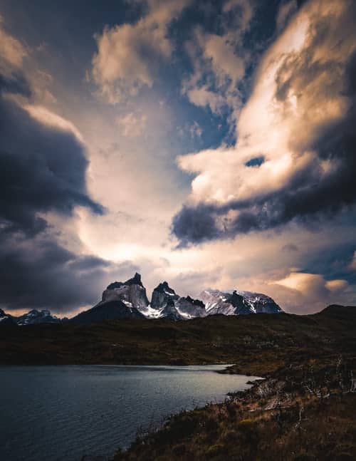
Quetrupillán Volcano
An inactive volcano near Pucón offering a challenging hike to a glacial crater with breathtaking panoramic views.

Highlights
Must-see attractions

Social
From TikTok & Reddit
Best Time
Snow is firm, fewer crowds
Quetrupillán Volcano
Best Time
Snow is firm, fewer crowds
Highlights
Must-see attractions
An inactive volcano near Pucón offering a challenging hike to a glacial crater with breathtaking panoramic views.
"The views from the top are mesmerizing of course. You can see a bunch of nearby volcanoes and Laguna, totally worth it!!"
🚗 Access & Fees
Fundo Porvenir offers good access. Expect a fee (around 10,000 CLP) for private land access.
🥾 Essential Gear
Crampons & poles needed for snow. Bring layers; summit is cold & windy.
Quick Facts
Rating
4.5 · 22 reviews
Type
Natural Feature
Highlights
Discover the most iconic attractions and experiences
The Glacial Crater
Summit
Stand on the edge of a vast, ancient crater, often covered by a magnificent glacier.
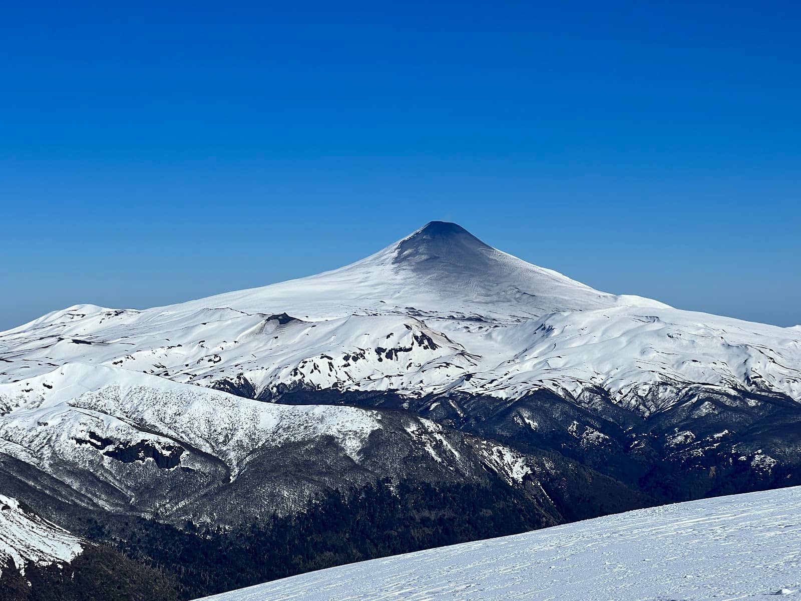
Panoramic Summit Views
Summit
Be rewarded with breathtaking 360-degree vistas of surrounding volcanoes like Villarrica and Lanín.
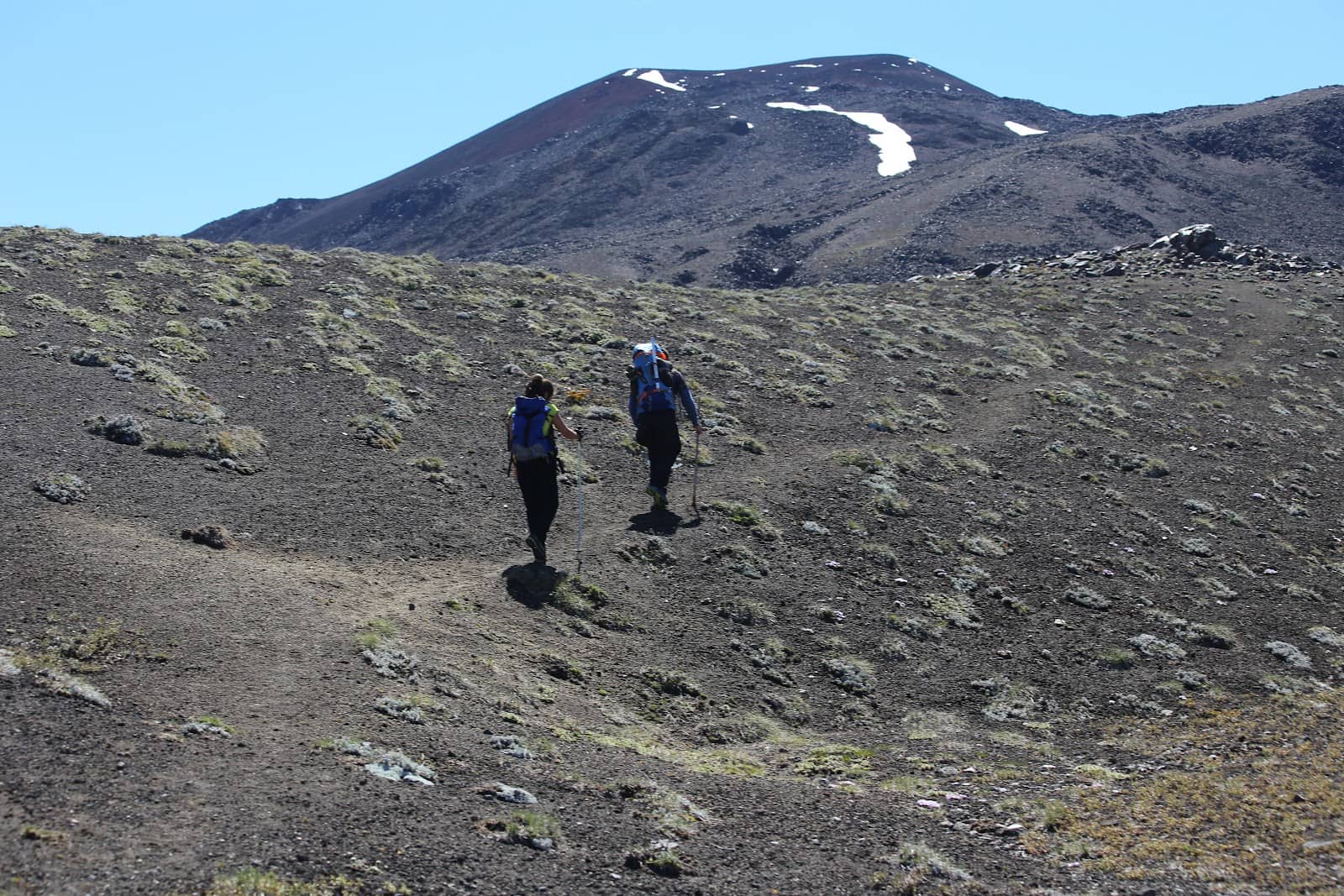
Diverse Trail Terrain
Ascent path
Trek through ancient forests, across rocky slopes, and over snowfields for a varied adventure.
Plans like a pro.
Thinks like you
Planning Your Visit
Timing is Everything for Snow & Views
Gear Up for the Summit
Best Times
Insider Tips
from TikTok, Instagram & Reddit
🚗 Access & Fees
Fundo Porvenir offers good access. Expect a fee (around 10,000 CLP) for private land access.
🥾 Essential Gear
Crampons & poles needed for snow. Bring layers; summit is cold & windy.
🗺️ Navigation
Use AllTrails or Wikiexplora for trail maps. Guides are optional but recommended for beginners. +1
👟 Boot Caution
Avoid agency-offered boots if they feel wrong; your own well-worn boots are better.
Tips
from all over the internet
🚗 Access & Fees
Fundo Porvenir offers good access. Expect a fee (around 10,000 CLP) for private land access.
🥾 Essential Gear
Crampons & poles needed for snow. Bring layers; summit is cold & windy.
🗺️ Navigation
Use AllTrails or Wikiexplora for trail maps. Guides are optional but recommended for beginners. +1
👟 Boot Caution
Avoid agency-offered boots if they feel wrong; your own well-worn boots are better.
⏰ Early Start
Begin early to hike on firm snow, especially in spring.
What Travellers Say
Reviews Summary
Visitors praise Quetrupillán Volcano for its challenging yet rewarding hike and spectacular summit views of surrounding volcanoes and a glacial crater. The diverse terrain and the sense of accomplishment are major draws. However, the hike is strenuous and requires proper preparation and gear, with some finding the trail difficult even with guides.
"In Oct'24 the ascend was technically easy and took us around 7hr until return (4.5 up, 2.5 down). There was still a lot of snow so would recommend to start early morning when snow is not soft yet and to bring crampons, gauntlets and hiking poles (maybe a plastic "sledge"/slider for the way down). No need for an ice ax as there is no climbing, just hiking. We rented the equipment from aguaventura in pucon and did the Tour ourselves without a guide. You can see the trail on AllTrails App, starting point is a farm at the end of a dirt road called Fundo Porvenir. When on top and weather permits you have a beautiful 360 view on the surrounded volcanoes including Villarica, Lanin and Osorno"
F S
"So I definitely got lost trying to find the trailhead for this hike but you can look up directions on wikiexplora. Once you are there, you just gotta park your car and you are good to go. About 20 minutes into the hike you'll hit a spot where they are charging 10 000 clp to access the land (January 2021). Again, it's a private land being managed by a third party company. The hike itself is exhausting I'm not gonna lie. I saw a lot of people hiking up the volcano with guides that ended up turning around because they couldn't keep up anymore. You should definitely have at least a few hikes with over 7000 feet elevation gain under your belt before attempting this one. The views from the top are mesmerizing of course. You can see a bunch of nearby volcanoes and Laguna, totally worth it!!"
Stanislav Alekseenko
"Quetrupillan is a classic climb near Pucón. It starts at the Hidden Paradise area, where you can leave your vehicle and begin the hike. The trail begins in the forest and then climbs the slopes of the volcano to its beautiful, large crater, which serves as a viewing point for the region's volcanoes."
Nicolás Meyer
What People Like
What People Dislike
Frequently Asked Questions
🚇 🗺️ Getting There
The most common access point is via Fundo Porvenir, which is reachable by car. The road can be a dirt track. Many visitors rent a car or arrange transport to the trailhead. Some tours also depart from Pucón. +1
Yes, it is possible to hike without a guide, especially if you are experienced and have good navigation skills. Using apps like AllTrails or Wikiexplora is highly recommended. +1
The hike typically starts at a farm called Fundo Porvenir, located at the end of a dirt road. There's an access fee for this private land. +1
Quetrupillán Volcano is located south of Pucón, approximately 800 km from Santiago. The drive from Pucón to the trailhead can take a couple of hours depending on road conditions.
Yes, you can drive to the Fundo Porvenir trailhead. The road is a dirt road, so a vehicle with decent clearance is advisable, though many cars manage.
🎫 🎫 Tickets & Entry
Yes, there is an access fee for hiking via Fundo Porvenir, which is private land. This fee was around 10,000 CLP as of January 2021.
Advance booking is generally not required for independent hikers. However, if you plan to join a guided tour, booking with the tour operator in advance is recommended.
As a natural attraction, there are no set operating hours. However, it's best to start your hike early in the morning, especially in winter or spring, to take advantage of firmer snow conditions.
No specific climbing permits are generally required for Quetrupillán Volcano for independent hikers. The main cost is the access fee for the private land.
While technically accessible year-round, conditions vary greatly. Winter and early spring require specialized gear due to snow and ice. Summer can be hot and dusty. +1
🎫 🥾 Onsite Experience
The hike is considered medium to difficult. It's exhausting and requires good physical condition. Some guides have turned back clients who weren't prepared. +1
The round trip typically takes about 6-7 hours. This includes approximately 4.5 hours for the ascent and 2.5 hours for the descent.
The trail is diverse, featuring forests, rocky slopes, snow, streams, and sand. This variety makes the hike challenging but rewarding.
Sturdy hiking boots are essential. In winter or snowy conditions, crampons, an ice axe, and gaiters are highly recommended. Layers of clothing are also crucial due to changing temperatures.
Facilities at the trailhead are minimal. Fundo Porvenir is a farm where you can park your car and begin the hike. It's advisable to bring all your own food and water.
📸 📸 Photography
The summit offers incredible 360-degree views of surrounding volcanoes and the glacial crater. The diverse trail terrain, including ancient forests, also provides great photo ops.
Absolutely. The dramatic volcanic landscapes, the glacial crater, and the panoramic views make it a prime location for landscape photographers.
Early morning or late afternoon often provide the best light for photography, with softer shadows and warmer tones. The summit views are spectacular in clear weather at any time.
While the focus is on the volcanic landscape, you might spot some local birdlife in the forested sections of the trail. Keep an eye out for native flora as well.
A wide-angle lens is great for capturing the expansive views. A telephoto lens can be useful for isolating distant peaks. Don't forget a sturdy tripod and protective gear for your camera in case of snow or rain.


Social
from TikTok, Instagram & Reddit