
Premužić Trail Northern Velebit
A 57km drystone masterpiece through Croatia's Velebit mountains, offering stunning sea & peak vistas.

Highlights
Must-see attractions

Social
From TikTok & Reddit
Best Time
Pleasant weather for hiking
Premužić Trail Northern Velebit
Best Time
Pleasant weather for hiking
Highlights
Must-see attractions
A 57km drystone masterpiece through Croatia's Velebit mountains, offering stunning sea & peak vistas.
"A masterpiece of hiking trail! Premužić Trail offers an unsurpassed crossing of the northern Velebit."
👟 Sturdy Hiking Boots
Essential for navigating the varied terrain of this 57km masterpiece.
💧 Carry Ample Water
Hydration is key! Refill points are scarce, so pack more than you think you'll need.
Quick Facts
Highlights
Discover the most iconic attractions and experiences
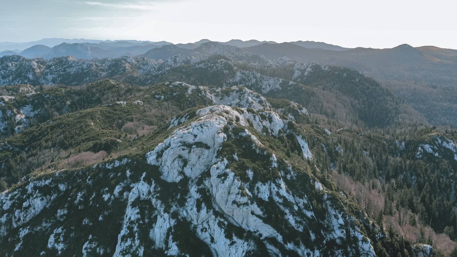
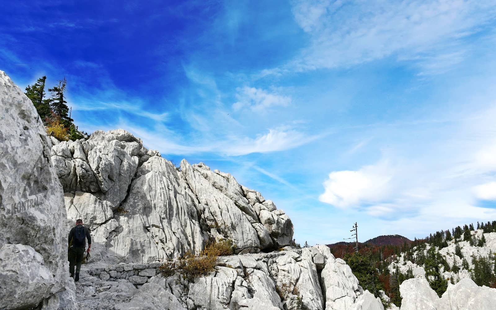
Drystone Masterpiece
Entire Trail
Marvel at the 1930s engineering feat, a 57km trail built without mortar, blending seamlessly with nature.
Gromovač Peak Views
Near Rossi's Hut
Ascend to 1630m for breathtaking panoramic views of peaks, the Adriatic Sea, and distant islands.
Adriatic Sea & Mountain Harmony
Various viewpoints
Experience the unique combination of rugged mountain landscapes and stunning vistas of the Adriatic coast.
Plans like a pro.
Thinks like you
Planning Your Visit
Best Time to Hike
Trail Preparedness
Best Times
Insider Tips
from TikTok, Instagram & Reddit
👟 Sturdy Hiking Boots
Essential for navigating the varied terrain of this 57km masterpiece.
💧 Carry Ample Water
Hydration is key! Refill points are scarce, so pack more than you think you'll need.
🧥 Layer Up!
Mountain weather is unpredictable. Be prepared for sun, wind, and potential rain.
🗺️ Download Offline Maps
Cell service can be spotty. Ensure you have offline maps for navigation.
Tips
from all over the internet
👟 Sturdy Hiking Boots
Essential for navigating the varied terrain of this 57km masterpiece.
💧 Carry Ample Water
Hydration is key! Refill points are scarce, so pack more than you think you'll need.
🧥 Layer Up!
Mountain weather is unpredictable. Be prepared for sun, wind, and potential rain.
🗺️ Download Offline Maps
Cell service can be spotty. Ensure you have offline maps for navigation.
📸 Capture the Views
Don't forget your camera! The vistas are truly breathtaking and worth documenting.
What Travellers Say
Reviews Summary
Visitors consistently praise the Premužić Trail as a 'masterpiece' and one of Europe's most beautiful hiking routes. Its unique drystone engineering, stunning panoramic views of the Adriatic Sea, and accessible terrain are major highlights. Some find the limited facilities and the need for advance booking at lodges to be minor inconveniences.
"A masterpiece of hiking trail!"
Vid Pogačnik
"Premužić Trail offers an unsurpassed crossing of the northern Velebit. It's truly a masterpiece."
Marko Kern
"Might be the best cut trail I have ever hiked"
Joey Donohue
What People Like
What People Dislike
Frequently Asked Questions
🚇 🗺️ Getting There
The most common starting point is from the Zavižan mountain lodge. You can reach Zavižan by car, with parking available. Public transport options are limited, so a car is often recommended for flexibility.
Yes, the trail is long (57km) and can be broken down into sections. Many hikers opt to hike between mountain lodges like Zavižan and Alan, making it accessible for day trips or shorter overnight stays.
The trail is often hiked from Zavižan towards Alan or vice versa. Zavižan is a popular starting point due to its accessibility and the lodge facilities.
While not as common as for some other European trails, local guides can sometimes be arranged, especially for longer or more challenging sections. It's best to inquire with local tourism offices or hiking associations.
Roads leading to trailheads like Zavižan can be winding and narrow. Drive cautiously, especially if you are not accustomed to mountain roads.
🎫 🎫 Tickets & Entry
The Premužić Trail is located within the Northern Velebit National Park. While the trail itself is generally accessible, there might be entrance fees for the national park, especially if you are using specific park facilities or entering through designated gates. It's advisable to check the official Northern Velebit National Park website for current entry fees and regulations.
As an outdoor hiking trail, the Premužić Trail does not have set opening or closing hours. It is accessible year-round, though winter conditions can make it dangerous.
No, there are no booking requirements to simply hike the Premužić Trail. However, if you plan to stay overnight at mountain lodges along the route, booking accommodation in advance is highly recommended, especially during peak season.
The trail itself is free to hike. The main costs would be transportation to the trailhead, potential national park entrance fees, and any accommodation or food expenses if you are staying overnight.
Yes, detailed hiking maps of the Premužić Trail and the Northern Velebit National Park are available for purchase at visitor centers, mountain lodges, and outdoor gear shops. Downloading offline maps on your phone is also a good idea.
🎫 🧭 Onsite Experience
The Premužić Trail is known for its gentle ascents and descents, making it suitable for beginner hikers. The drystone construction ensures a relatively smooth path, though it is still a mountain trail requiring good footwear.
The entire 57km trail typically takes 2 to 3 days to complete, depending on your pace and whether you are hiking sections or the full length. Some experienced hikers may do it faster, but it's best to allow ample time.
Yes, there are mountain lodges (e.g., Zavižan, Alan, Rossi shelter) along the trail that offer basic accommodation. Booking in advance is crucial, especially during peak season.
The Velebit region is rich in biodiversity. You might encounter various bird species, chamois, and if you're very lucky, perhaps even signs of bears or wolves, though sightings are rare.
The Premužić Trail is generally well-marked with standard hiking trail blazes. However, it's always wise to carry a map and compass or GPS device.
🍽️ 🍽️ Food & Dining
Dining options are very limited. Mountain lodges along the trail may offer meals, but it's not guaranteed and depends on the season and availability. It's best to pack your own food and snacks.
Pack high-energy, non-perishable foods like trail mix, energy bars, dried fruit, nuts, and sandwiches. Ensure you have enough for your entire hike, plus a little extra.
Some mountain lodges offer food and drinks, but this can vary. It's not a reliable source for all your meals, so self-sufficiency is key.
Potable water sources are scarce. While some lodges might have water, it's safest to carry all the water you'll need or bring a water filter/purification tablets.
Closer to the main access points like Zavižan, you might find small local restaurants or konobas, but once you are on the trail, options disappear.
📸 📸 Photography
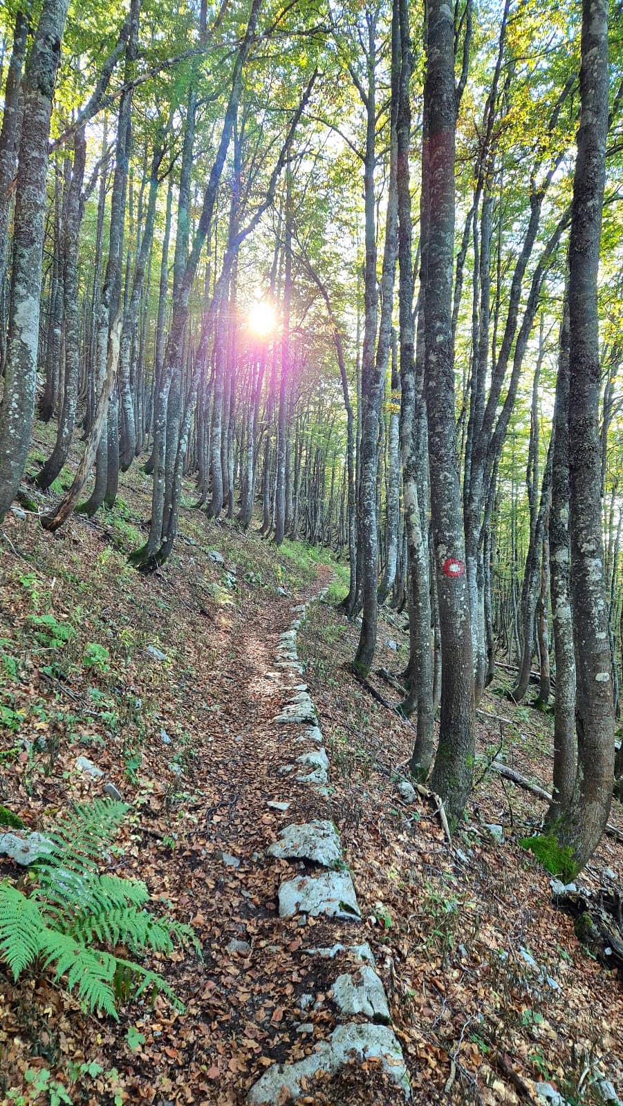
Everywhere! The trail itself, with its drystone walls, offers unique architectural shots. The panoramic views from higher points, especially towards the Adriatic Sea and islands, are spectacular. Don't miss the karst formations and the rugged mountain landscapes.
Golden hours, shortly after sunrise and before sunset, offer the most dramatic lighting for landscape photography. Midday can be harsh, but it's great for capturing the details of the drystone construction.
A good quality camera or smartphone with a decent camera will suffice. Consider a wide-angle lens for landscapes and a telephoto lens if you want to capture distant islands or wildlife. Protection from the elements is also wise.
Generally, there are no restrictions on personal photography for non-commercial use within the national park. However, always be respectful of the natural environment and any wildlife.
Sections with dramatic drop-offs, sweeping vistas of the sea, and the intricate drystone walls are particularly photogenic. The area around Gromovač peak is a must-photograph spot.


Social
from TikTok, Instagram & Reddit