
Belvédère de Pirae Mount Aorai Trailhead
A challenging, rewarding hike offering breathtaking panoramic views of Tahiti and its surrounding islands. Prepare for steep ascents and stunning ridg...
Highlights
Must-see attractions

Social
From TikTok & Reddit
Best Time
Beat the heat and enjoy clear views
Belvédère de Pirae Mount Aorai Trailhead
Best Time
Beat the heat and enjoy clear views
Highlights
Must-see attractions
A challenging, rewarding hike offering breathtaking panoramic views of Tahiti and its surrounding islands. Prepare for steep ascents and stunning ridge trails.
"The views are amazing and the air is so clean to breathe. "
👟 Sturdy Hiking Shoes Essential
Loose dirt and pine needles make the trail slippery. Good traction is crucial for both ascent and descent. :athletic_shoe:
💧 Carry Plenty of Water
The only reliable water source is at the final refuge. Stay hydrated throughout your challenging hike. :droplet:
Quick Facts
Highlights
Discover the most iconic attractions and experiences
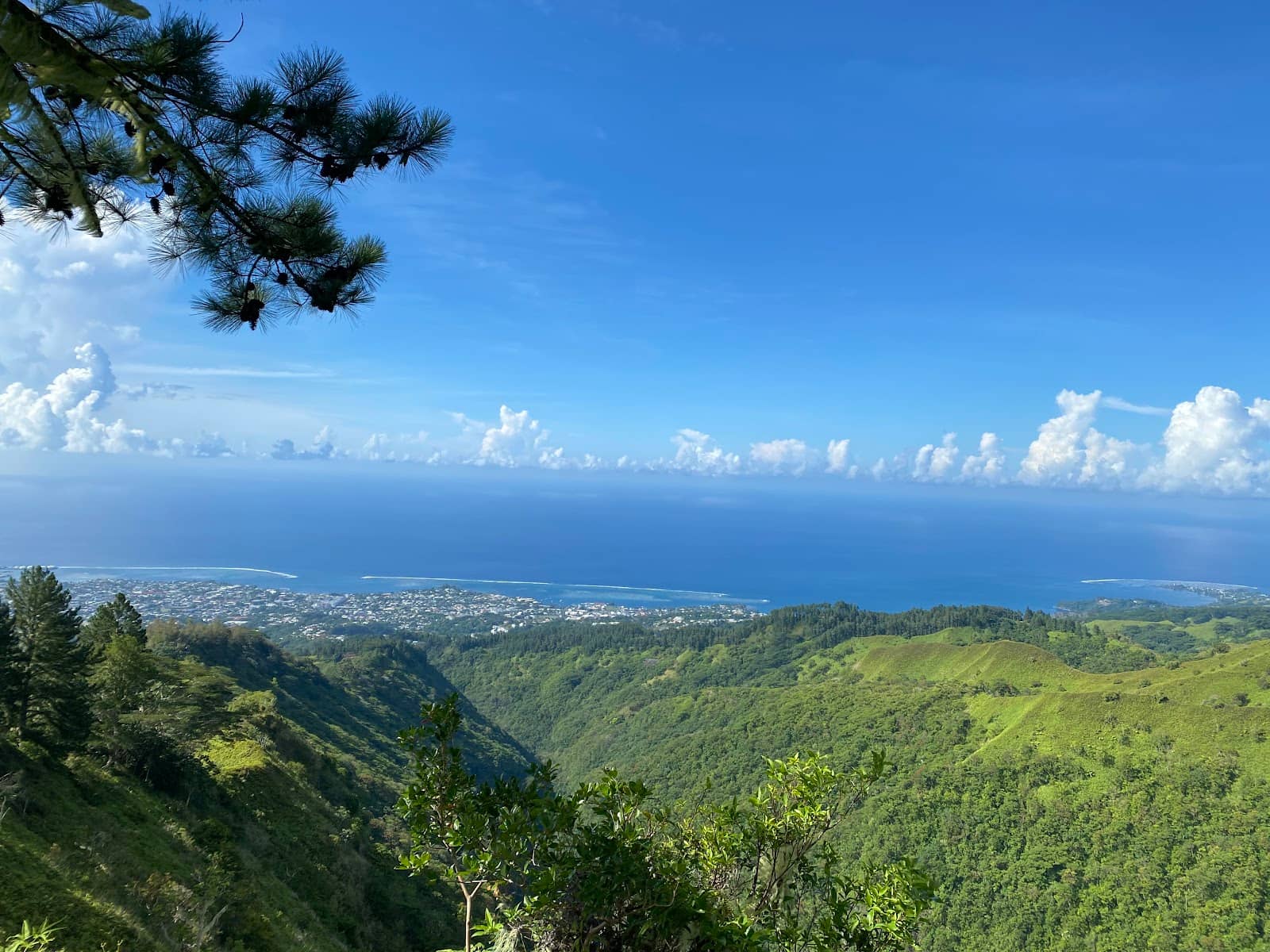
Panoramic Summit Views
Mount Aorai Summit
Breathtaking 360-degree vistas of Tahiti and surrounding islands. Worth the strenuous climb for unparalleled scenery.
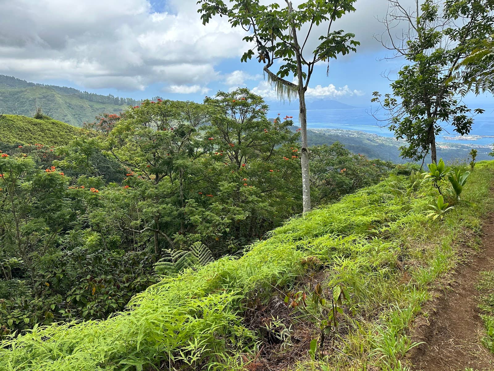
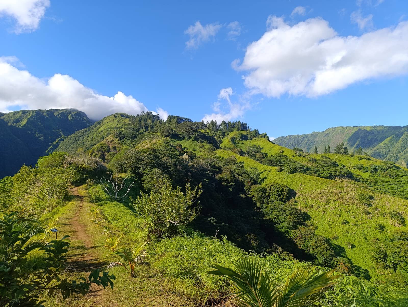
The Ridge Trail
Upper sections of the trail
Hike along narrow ridges with dramatic drops, offering a thrilling and scenic experience.
Refuge Stops
First and Second Refuges
Rest stops with basic amenities, offering a chance to refuel and appreciate the changing landscape.
Plans like a pro.
Thinks like you
Planning Your Visit
Prepare for a Challenging Hike
Navigating the Access Road
Best Times
Insider Tips
from TikTok, Instagram & Reddit
👟 Sturdy Hiking Shoes Essential
Loose dirt and pine needles make the trail slippery. Good traction is crucial for both ascent and descent. :athletic_shoe:
💧 Carry Plenty of Water
The only reliable water source is at the final refuge. Stay hydrated throughout your challenging hike. :droplet:
👖 Wear Trousers
Overgrown ferns and narrow paths mean trousers are recommended to protect your legs. :pants:
🚗 Access Road Caution
The last 4km is a single lane. Drive slowly and be prepared to yield or back up. :red_car:
Tips
from all over the internet
👟 Sturdy Hiking Shoes Essential
Loose dirt and pine needles make the trail slippery. Good traction is crucial for both ascent and descent. :athletic_shoe:
💧 Carry Plenty of Water
The only reliable water source is at the final refuge. Stay hydrated throughout your challenging hike. :droplet:
👖 Wear Trousers
Overgrown ferns and narrow paths mean trousers are recommended to protect your legs. :pants:
🚗 Access Road Caution
The last 4km is a single lane. Drive slowly and be prepared to yield or back up. :red_car:
⬆️ First Half is Easier
The initial 3.5km offers great views and is less intense than the upper sections. ⬆️
What Travellers Say
Reviews Summary
Visitors rave about the absolutely extraordinary and fabulous landscapes and clean air, making the challenging hike a fantastic experience. However, the trail is very demanding with slippery terrain and a difficult access road, requiring careful planning and proper equipment.
"This review is for the person who is an occasional hiker. (Those of you who hike often, you already have hiking guide resources that will be far better suited to you experienced exploring.) This hiking trail is very challenging and it should not be taken without careful planning.
You will need to take water with you as the only source of drinking water is at the very end of a difficult trail at the second and final refuge. Also, there is practically no way for emergency services to quickly reach you if you need help, except for maybe a helicopter (but there is no place for a helicopter to land near the trail). (Call 15 or 112 for emergency services.)
Proper hiking shoes with very good traction is very important. The trail, even when it is dry, is slippery from the loose dirt and especially the ubiquitous dead long pine needles covering entire sections of the trail. Going up is challenging but there are a few ropes to help you with an otherwise imposingly steep path. However, coming down on that type of loose terrain is extremely difficult. If it rains, the resulting mud makes the path very difficult and dangerous. Finally, the almost 2km single lane road to the starting point of the trail has almost no space for cars traveling in opposite directions to pass each other without one of the cars pulling off to the side of the road. See the photos of the road… tourists in rental cars should avoid driving here. There is a fancy restaurant at the top of the road and there is some parking for restaurant guests. There is no parking for others except for a handful of roadside curb areas into which one could squeeze a compact car without falling of the edge and down the steep hill.
So, you may wonder why 5 stars after all of the preceding warnings? The views are amazing and the air is so clean to breathe. Although there are significant challenges for the average healthy person to make this hike, if you prepare well and have the right equipment (e.g., water, hiking shoes, protective clothing and some common sense about the trail conditions and not pushing yourself too hard) the hike is a fantastic experience."
Nabil Foster
"A 30 minute drive from the city. You can go in the morning and finish for lunch and swimming at the restaurant or go in the afternoon and finish for dinner. There are two sections to the trail. The first is easy and goes for 60-90 minutes to the third bench. After that, the trail will get more intense and continue to an overnight hut. The trail is in good condition and safe, but if you have a fear of heights you may want to proceed with caution."
Lief Friedrichs
"This trail is usually started from the O' Belvedere restaurant and the first problem is the drive to the starting location is quite scary. The last 4 kilometers of the drive is on a narrow 1 lane road that only fits 1 vehicle. When oncoming traffic arrives, you may have to back up a long time to find a location where one vehicle can pull over to allow the other to pass. I was extremely lucky and every time there was oncoming traffic, a shoulder was readily available. When it rains, the shoulder areas are not well paved and I was constantly worried about my 2WD rental vehicle getting stuck. Thankfully it was mostly ok. I ended up not driving all the way to the restaurant although there is plenty of parking at the top and ended up parking about 1.5km from the restaurant/trailhead near the entrance of a private residence where there was a large flat turn-out next to the road.
The trail itself is more challenging than Mont Marau and the views are not quite as good. Path is extremely narrow with many areas requiring on foot after another. Some areas with a sleep slide area without even vegetation as a guard rail. Ended up stopping after 2 kilometers without reaching the first refuge because the overgrown vegetation was making it hard to even see the right path. It's still a fun trail but know your limits and don't overdo it. It was overall still a fun experience and maybe if I had a more experience guide by my side, I would be willing to make it up further."
Victor Wang
What People Like
What People Dislike
Frequently Asked Questions
🚇 🗺️ Getting There
The trailhead is typically accessed via the O'Belvédère restaurant. The final 4 kilometers are on a narrow, single-lane road that requires careful driving. Be prepared for oncoming traffic and potential need to back up. Some visitors opt to park about 1.5km before the restaurant on a large turn-out.
While possible, the narrow, unpaved shoulders can be challenging for rental cars, especially if it rains. 2WD vehicles may struggle. Experienced drivers or those with 4WD might find it easier.
The drive is approximately 30 minutes from the main city area, but can vary depending on traffic and your comfort level on the narrow access road.
Yes, there is parking available at the O'Belvédère restaurant. However, it can fill up, and some visitors choose to park further down the road on available turn-outs.
While taxis might be available, the challenging access road might deter some drivers. It's advisable to confirm with the taxi service beforehand. Rideshare availability can be inconsistent.
🎫 🎫 Tickets & Entry
No, there are no tickets or entry fees required to access the Mount Aorai hiking trail. It is a public access trail.
The trail is generally accessible at all hours, but it's highly recommended to hike during daylight for safety and visibility. Starting early in the morning is advised.
The O'Belvédère restaurant does not typically charge an entrance fee, but it is a dining establishment. Parking is available for patrons.
No specific permits are generally required for day hiking on the Mount Aorai trail. However, always check local regulations for any updates.
Yes, there is an overnight hut available on the trail. It's advisable to check availability and any associated booking requirements in advance if you plan to stay overnight.
🎫 🥾 Onsite Experience
The Mount Aorai hike is considered very challenging, especially the upper sections. It involves steep ascents, technical passages, and slippery terrain. It's not recommended for casual hikers.
The trail is generally in good condition but can be narrow and overgrown in parts. Expect steep sections, loose dirt, pine needles, and some areas with ropes for assistance. Trousers are recommended due to vegetation.
A full ascent to the summit can take around 6 hours of walking, with a descent taking about 4.5 hours. The first half to the third bench takes about 60-90 minutes.
There are two refuges along the trail. The second and final refuge has a water source, but it's not guaranteed to be drinkable. It's best to carry all the water you need.
Wear sturdy hiking shoes with excellent traction. Trousers are recommended due to overgrown vegetation. Layers of clothing are advisable as conditions can change.
📸 📸 Photography
The summit offers incredible panoramic views of Tahiti and the surrounding islands. The ridge sections also provide dramatic and photogenic landscapes.
Mornings often provide clearer skies and softer light for photography. Sunsets can also be spectacular, but ensure you descend safely before dark.
A wide-angle lens is great for capturing the expansive views. Consider a sturdy tripod if you plan for low-light photography. Protect your gear from potential rain or humidity.
The summit is the ultimate viewpoint. The first refuge area and various points along the ridge trails also offer stunning photographic moments.
Drone regulations can vary. It's best to check with local authorities or the O'Belvédère restaurant for any restrictions on drone usage in the area.


Social
from TikTok, Instagram & Reddit