
Mount St. Catherine Grenada
Grenada's highest peak, a dormant volcano offering a challenging trek through lush rainforest to potentially stunning island views.

Highlights
Must-see attractions

Social
From TikTok & Reddit
Best Time
Clearer views, less mud
Mount St. Catherine Grenada
Best Time
Clearer views, less mud
Highlights
Must-see attractions
Grenada's highest peak, a dormant volcano offering a challenging trek through lush rainforest to potentially stunning island views.
"A challenging trek essential for adventurers, with guides a must and nature's rewards along the way."

🎯 Hire a Local Guide
Essential for navigation, especially after storms. Guides know the best routes and can point out water sources. :hiking_boot:
💪 Pack for a Strenuous Hike
Good fitness and stamina are crucial. The trek is long and challenging, with mud and climbing. :athletic_shoe:

Quick Facts
Rating
3.9 · 14 reviews
Type
Natural Feature
Highlights
Discover the most iconic attractions and experiences
Summit Views
Mount St. Catherine Summit
Reach the highest point in Grenada for panoramic island vistas, weather permitting. The reward for a challenging trek.

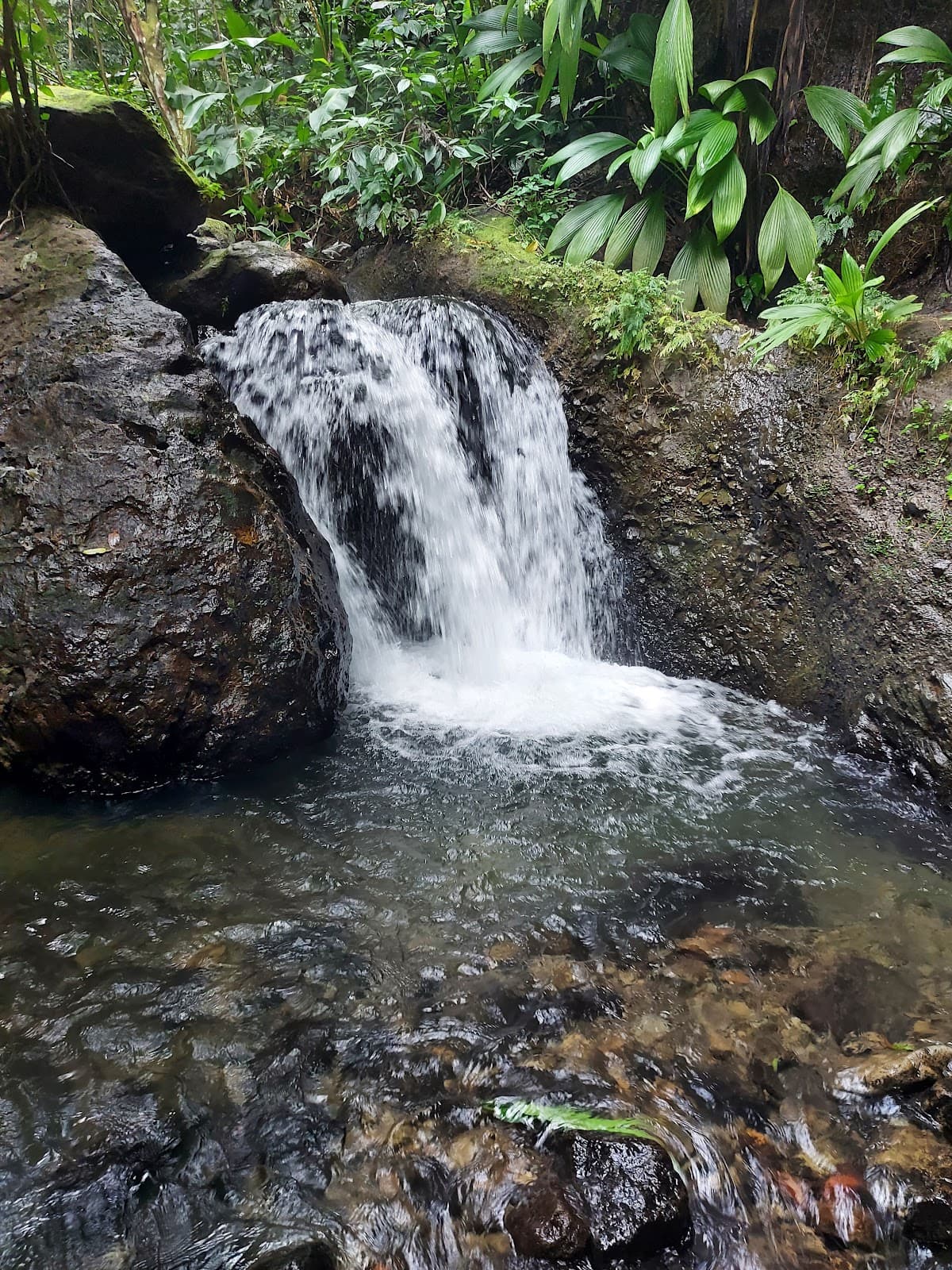
Freshwater Springs
On the Mount St. Catherine Trail
Refill your water bottles with pure, natural spring water found along the trek. A refreshing and unique perk of the hike.

Mount St. Catherine Forest Reserve
St. Mark Parish
Explore the lush biodiversity of this protected area, home to Grenada's highest peak and diverse flora.
Plans like a pro.
Thinks like you
Planning Your Visit
Guide Up Mount St. Catherine
Best Footwear for the Hike
Best Times
Insider Tips
from TikTok, Instagram & Reddit
🎯 Hire a Local Guide
Essential for navigation, especially after storms. Guides know the best routes and can point out water sources. :hiking_boot:
💪 Pack for a Strenuous Hike
Good fitness and stamina are crucial. The trek is long and challenging, with mud and climbing. :athletic_shoe:
💧 Bring Plenty of Water
Carry more than you think you'll need. Refill points are limited and depend on your guide. :droplet:
🥾 Sturdy Hiking Boots
Absolutely necessary for slippery mud, water crossings, and rocky ascents. :hiking_boot:
Tips
from all over the internet
🎯 Hire a Local Guide
Essential for navigation, especially after storms. Guides know the best routes and can point out water sources. :hiking_boot:
💪 Pack for a Strenuous Hike
Good fitness and stamina are crucial. The trek is long and challenging, with mud and climbing. :athletic_shoe:
💧 Bring Plenty of Water
Carry more than you think you'll need. Refill points are limited and depend on your guide. :droplet:
🥾 Sturdy Hiking Boots
Absolutely necessary for slippery mud, water crossings, and rocky ascents. :hiking_boot:
📸 Capture the Journey
While summit views can be obscured, the trek itself offers unique forest scenery. :camerawithflash:
What Travellers Say
Reviews Summary
Mount St. Catherine offers a challenging but rewarding trek for the adventurous, with the necessity of a guide highlighted due to trail conditions. While summit views can be elusive, the journey through the forest and the unique natural springs are appreciated. Some find the trail's upkeep lacking, suggesting alternatives for easier hikes.
"Mount St Catherine is accessible by trek only. From costal town Victoria, ride 10 min by car then leave it when paved road ends.
You absolutely need a guide as - at least when we have done it yesterday, 14th October 2024, the track to go all the way up was in poor shape following hurricanes and storms a few months ago.
It took us about 4.5 hours to reach the top and 4 hours to come down. No ropes needed but certain parts of the trek go over water (at the beginning), mud and at some places basic climbing is required.
After 2 hours in the way up, the guide can go to fill up your bottles with freshwater from a nearby spot. He can do the same on the way down.
It would have been impossible for us to reach the top without a guide. Too “messy” to find the correct way. Good fitness is required and definitely stamina.
In the pictures attached I am trying to give an idea of the tracks and views. You will find also two GPS maps (one starting from car to a bit up and then the other one all the way up).
Cannot give 5 stars as there are nice views but often no views at all deep under the bush. And although I do not need a groomed track, the state of the way up (which is the same as the way down) is poor.
As a much easier alternative with much nicer views, I recommend the Mount Qua Qua also in Grenada island (this streak starts from the Grand Étang)."
Antoine Deroide
"The walk is really not bad to get there, however the top is really not welcoming. Bush and wire everywhere."
Leslie Lalgie
"A great hike with beautiful views 🤩
Mount Saint Catherine is an extensively weathered stratovolcano mountain on the Caribbean island of Grenada. Its summit in St. Mark's, Victoria is one of the highlights of the Mount St. Catherine Forest Reserve.
The Mt. St. Catherine massif is the youngest of the five volcanoes on the island. The volcano has a ~1.5-km horseshoe-shaped crater open to the east, where a complex of volcanic lava domes occur across its flanks and is monitored by the Seismic Research Center of the University of the West Indies. The volcano is considered dormant because it has likely not erupted since the last Ice Age.[1] It is considered to be the only live volcano among the five volcanic centers in Grenada on account of its relatively well preserved morphology and the presence of hot springs and fumaroles on its flanks. Although violent eruptions occurred in the geological past (i.e. Pleistocene—2,588,000 to 11,700 years ago), revealed by voluminous pyroclastic-flow deposits extending northwest of the summit, this type of volcanic activity is now considered unlikely to occur in the near future.
The mountain summit is accessible by 3 steep rugged routes crossing the forest reserve. Tours are available, as well as guided trips to Tufton Hall Waterfall, the highest waterfalls on the island, off the southeastern flank of the mountain."
Vix Macanthony
What People Like
What People Dislike
Frequently Asked Questions
🚇 🗺️ Getting There
The most common starting point is the coastal town of Victoria. From there, you'll need to arrange transport to where the paved road ends, typically a 10-minute drive. From that point, the trek begins.
Public transport is limited to Victoria. You'll likely need to hire a taxi or arrange a private transfer from Victoria to the trailhead.
You can drive to a certain point where the paved road ends. Beyond that, a 4x4 vehicle might be necessary for a short distance, but the final ascent is on foot.
Hiring a local taxi from Victoria is recommended. They can take you as far as possible and often have connections for guides.
Parking is informal and limited to where the road ends. It's advisable to discuss parking with your driver or guide.
🎫 🎫 Tickets & Entry
While there isn't a formal ticket booth, hiring a guide is highly recommended and often considered part of the entry requirement due to trail conditions.
There are no official opening hours as it's a natural reserve. However, it's best to start your hike early in the morning and complete it within daylight hours.
There isn't a set entrance fee, but the cost of hiring a guide is significant and should be factored into your budget.
It is strongly advised against visiting without a guide, especially after recent storms, as the trails can be treacherous and difficult to navigate.
Guide fees can vary, but expect to pay a substantial amount for a full-day trek. It's best to negotiate the price beforehand.
🎫 🧭 Onsite Experience
The trek to the summit and back typically takes around 8-9 hours, with about 4.5 hours up and 4 hours down.
It's considered a strenuous hike requiring good fitness and stamina. The trail involves mud, water crossings, and basic climbing.
Views from the summit can be spectacular, offering panoramic island vistas. However, they are often obscured by clouds or dense bush, especially after storms.
No, there are no facilities at the summit. It's a natural environment, and you should be prepared to carry out everything you bring in.
Mount St. Catherine is considered a dormant stratovolcano. While it has hot springs and fumaroles, violent eruptions are unlikely in the near future.
📸 📸 Photography
While summit views can be hit or miss, the lush forest, unique flora, and challenging trail sections offer great photographic subjects. Don't miss the freshwater springs.
If you're an avid nature photographer, yes. Be prepared for humidity and potential rain. A good phone camera can also capture the essence of the trek.
On a clear day, you might catch glimpses of the coastline, but the dense vegetation often limits these views.
Expect shots of dense jungle, muddy paths, water crossings, and potentially unique plant life. It's a very 'in the thick of it' kind of photography.
The summit is the primary viewpoint, but your guide might know of smaller clearings along the trail that offer interesting perspectives.


Social
from TikTok, Instagram & Reddit