High Junk Peak Hong Kong
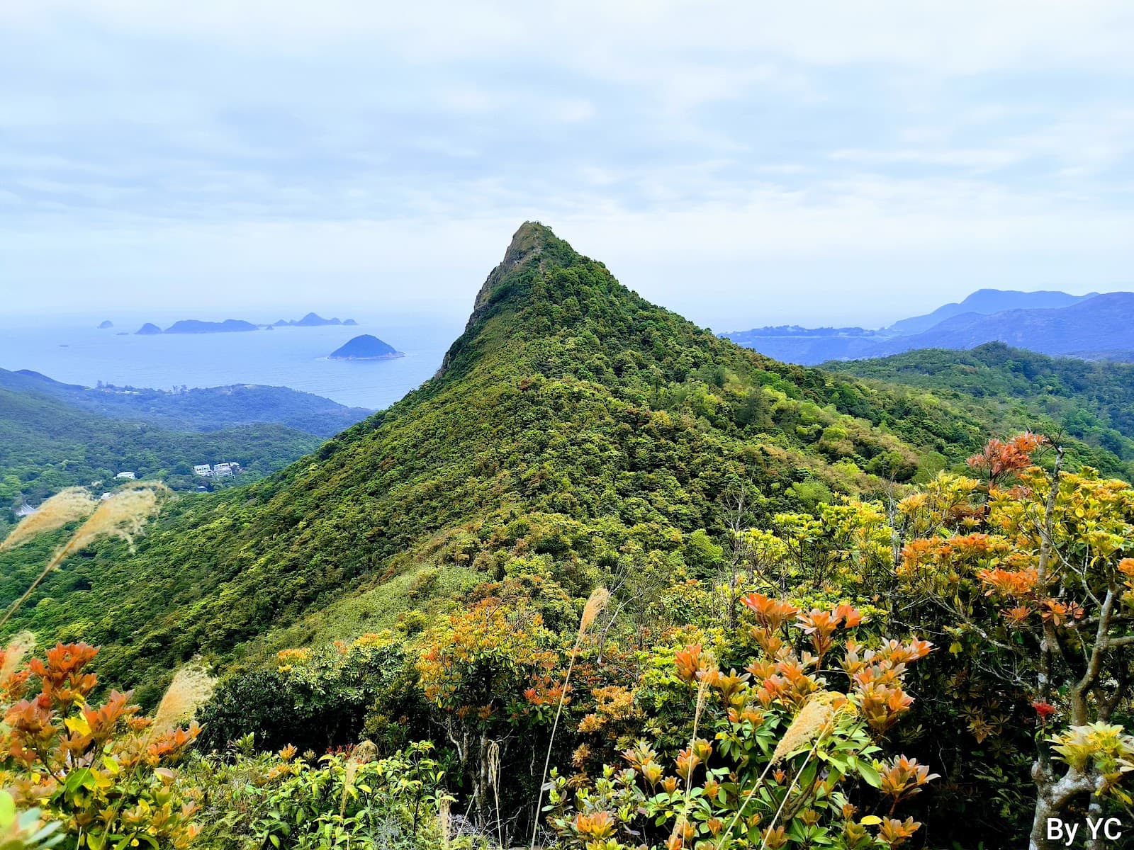
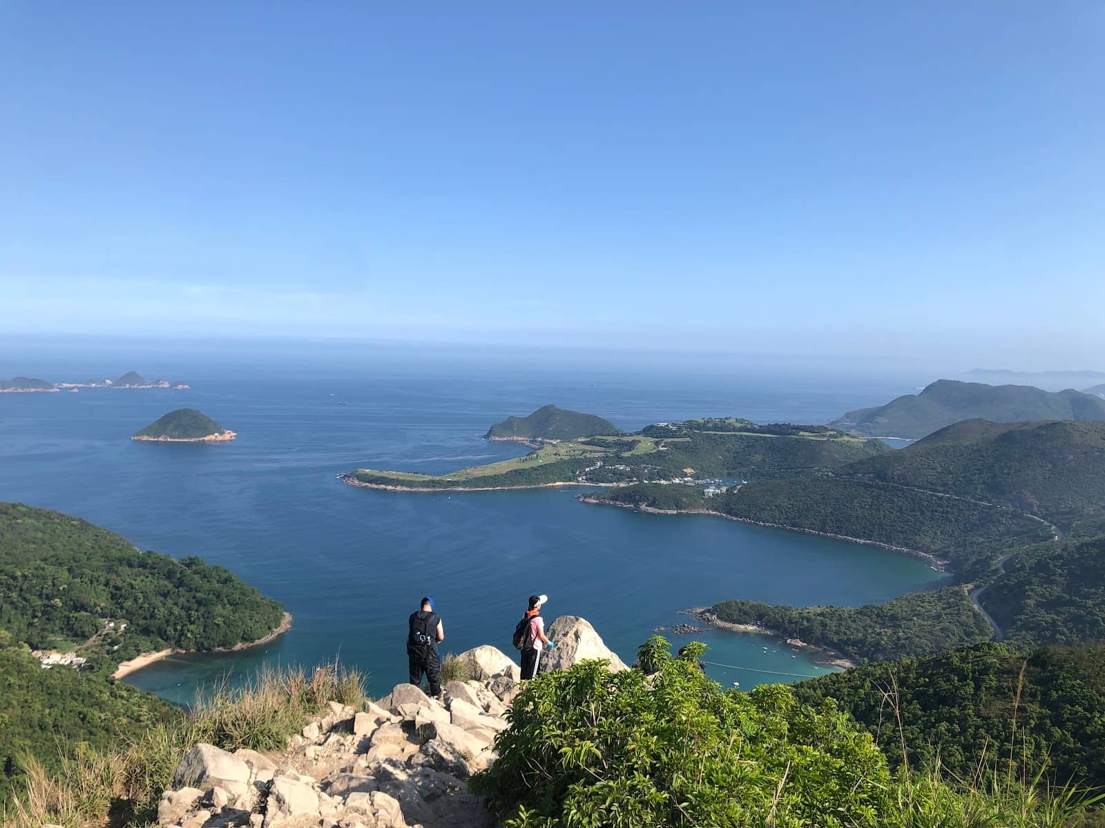
A challenging Hong Kong hike offering breathtaking panoramic views of Clear Water Bay and surrounding islands from its steep summit.

Highlights
Must-see attractions

Social
From TikTok & Reddit
Best Time
Fewer crowds, cooler temps

High Junk Peak Hong Kong
Best Time
Fewer crowds, cooler temps

Highlights
Must-see attractions
A challenging Hong Kong hike offering breathtaking panoramic views of Clear Water Bay and surrounding islands from its steep summit.
"The views from High Junk Peak are absolutely spectacular and worth every step of the challenging climb!"

👟 Sturdy Hiking Shoes Are a Must
The terrain is rocky and steep. Good grip is essential to prevent slips and ensure a safe, enjoyable hike. :athletic_shoe:
💧 Hydration is Key
Carry more water than you think you'll need, especially during warmer months. There are no facilities on the trail. :droplet:

Highlights
Discover the most iconic attractions and experiences

Summit Panorama
Summit of High Junk Peak
Breathtaking 360-degree views of Clear Water Bay, Sai Kung, and surrounding islands. A true reward for the strenuous climb.

The Steep Ascent
Main trail to the summit
The challenging, rocky path offers a sense of accomplishment with every step. It's a test of endurance with rewarding scenery.

Clear Water Bay Coastal Views
Along the trails
Glimpses of the turquoise waters and sandy beaches of Clear Water Bay provide a beautiful contrast to the rugged terrain.
Plans like a pro.
Thinks like you
Planning Your Visit
Conquer the Climb: What to Know Before You Go
Timing Your Trek for the Best Views
Best Times
Insider Tips
from TikTok, Instagram & Reddit
👟 Sturdy Hiking Shoes Are a Must
The terrain is rocky and steep. Good grip is essential to prevent slips and ensure a safe, enjoyable hike. :athletic_shoe:
💧 Hydration is Key
Carry more water than you think you'll need, especially during warmer months. There are no facilities on the trail. :droplet:
☀️ Start Early to Beat Heat
The sun can be intense. An early start means cooler temperatures and fewer people on the popular trails. :sunrise:
🗺️ Download Offline Maps
Cell service can be spotty. Having an offline map on your phone is a lifesaver for navigation. :iphone:
Tips
from all over the internet
👟 Sturdy Hiking Shoes Are a Must
The terrain is rocky and steep. Good grip is essential to prevent slips and ensure a safe, enjoyable hike. :athletic_shoe:
💧 Hydration is Key
Carry more water than you think you'll need, especially during warmer months. There are no facilities on the trail. :droplet:
☀️ Start Early to Beat Heat
The sun can be intense. An early start means cooler temperatures and fewer people on the popular trails. :sunrise:
🗺️ Download Offline Maps
Cell service can be spotty. Having an offline map on your phone is a lifesaver for navigation. :iphone:
🎒 Pack Light, But Smart
Bring essentials like snacks, sunscreen, and a basic first-aid kit. Avoid overpacking to keep your climb manageable. :backpack:
What Travellers Say
Reviews Summary
Hikers rave about the absolutely stunning panoramic views from the summit of High Junk Peak, calling it a must-do for its rewarding vistas. The challenging, steep climb is often cited as a significant part of the experience, offering a great sense of accomplishment. However, some find the trail very demanding and advise thorough preparation.
"Beautiful hike with breathtaking views of sai Kung and east Kowloon. Only the final section of the climb to the peak was a bit treacherous, otherwise it’s a fairly beginner friendly hike. Takes about 2 hours to complete, maybe 2.5-3 if you hike all the way to clear water bag"
Justin Yiu
"This is a really beautiful hike that takes in some great views.
A lot of the hike is open so choose a day that's not too hot with some decent visibility so you can take it all in.
I started from Clearwater Bay Road so the ascent isn't that hard as you reach the smaller peak first.
The hike up to High Junk is not hard, but the surface is a little slippery due to the dry months.
Once at the top you have the most incredible 360° view, which is why a good visibility day is useful.
Heading down is not too difficult except for the initial part which is a bit crumbly. Stone steps after that.
Great day out. Not too hard. Amazing views.
Recommended."
C
"Overview
- Start up point near Mtr
- Beautiful Sai Kung Harbour view
- Be cautios about downhill steps
Gathered at Hang Hau mtr exit B at 8 am. Walked along Pui Shing Road for about 10 mins and turned right to Po Ning Road, you will see Boon Kin Village (半見村).
Entered into the village and walked uphill towards High Junk Peak. The path to the Peak is neither difficult nor dangerous. Near the peak, the path becomes narrower and you should be more cautious.
When you see the Peak, do not forget to take photos before proceeding. Along the trail, you will see the Harbour and bridge view of Tseung Kwan O and Sai Kung Sea view.
At the Peak, it will be cold becsuse of the strong wind chill effect. There are a lot of rocks near the High Junk Peak, good for photo shooting.
Great cautious must be taken when walking downhill as steps are made of rocks and stones. Different hight in step will increase the pressure on your knees. Furthermore, some steps are quite steep.
The overall trail will take about 3 hours to complete. You may exit to Lohas to take mte or Clear Water Bay road to take mini bus."
Jacob Lee
What People Like
What People Dislike
Frequently Asked Questions
🚇 🗺️ Getting There
The most common starting point is near the Clear Water Bay Country Club. You can take public transport like bus routes 91 or 91M to reach the area. From the bus stop, follow signs for the hiking trails. Some hikers suggest starting from Fei Ngo Shan Road for a different route.
Bus routes 91 and 91M are popular choices, dropping you off close to trailheads. Check the latest bus schedules as they can vary. Taxis are also an option but can be more expensive.
Limited parking is available near the Clear Water Bay Country Club and along some access roads. However, parking can fill up quickly on weekends, so public transport is often recommended.
Yes, while the Clear Water Bay Country Club area is popular, some hikers opt for starting points like Fei Ngo Shan Road, which offers alternative routes and perspectives.
Depending on traffic and your starting point, it can take approximately 45-60 minutes by car or taxi. Public transport might take longer, around 1 to 1.5 hours.
🎫 🎫 Tickets & Entry
No, High Junk Peak and its surrounding trails are part of the Hong Kong Country Parks system and are free to access. No tickets are required for entry. :free:
The trails are open 24/7 as they are part of the country parks. However, it's highly recommended to hike during daylight hours for safety and visibility. :clock10:
There is no entrance fee to hike High Junk Peak. It's a public hiking trail managed by the Agriculture, Fisheries and Conservation Department (AFCD).
While technically possible, hiking High Junk Peak at night is strongly discouraged due to safety concerns, lack of lighting, and potential for getting lost. Stick to daylight hours. :flashlight:
No booking is required. High Junk Peak is an open hiking trail accessible to everyone. Just show up ready to hike!
🎫 🥾 Onsite Experience
The hike is considered moderately to difficult due to its steep, rocky ascents and descents. It requires a good level of fitness and stamina. :muscle:
Many hikers prefer the trail starting near Clear Water Bay Country Club, which leads to the summit. There are various routes, so consult a trail map for options. :map:
The time can vary greatly depending on your fitness level and chosen route, but typically expect 3-5 hours for a round trip, including time at the summit.
There are very limited facilities. Basic restrooms might be found near the starting points or country park visitor centers, but not along the main hiking path itself. Plan accordingly. :toilet:
Expect spectacular panoramic views of Clear Water Bay, Sai Kung Peninsula, the South China Sea, and surrounding islands. It's a photographer's paradise. :camera:
🍽️ 🍎 Food & Dining
No, there are no food stalls or restaurants directly on the High Junk Peak trail. You'll need to bring all your own food and drinks. :sandwich:
Pack energy-rich snacks like trail mix, energy bars, fruits, and sandwiches. Ensure you have plenty of water. :apple:
After your hike, you can find restaurants and cafes in nearby areas like Sai Kung town or around the Clear Water Bay vicinity. Sai Kung is particularly known for its seafood. :fish_cake:
Picnicking is allowed in designated country park areas, but remember to pack out all your trash. Enjoy your meal with a view! :picnic_sun:
You might find some limited options near the Clear Water Bay Country Club, but for a wider selection, it's best to head to Sai Kung town or other developed areas. :coffee:
📸 📸 Photography
Early morning or late afternoon (golden hours) offer the best light for photography, with softer shadows and warmer tones. Midday sun can be harsh. :star2:
A wide-angle lens is great for capturing the panoramic vistas. A sturdy tripod can be useful for sunrise/sunset shots. Don't forget a protective case for your gear. :camerawithflash:
The summit itself offers the most iconic panoramic shots. Look for interesting rock formations along the trail for unique perspectives. :mountain:
Drone usage in Hong Kong Country Parks is generally restricted or requires permits. It's best to check the latest regulations with the AFCD before flying. :drone:
Besides the summit, look for dramatic rock formations, the contrast between the green hills and blue sea, and the winding trails themselves. :camerawithflash:
For Different Travelers
Tailored advice for your travel style
👨👩👧 Families with Kids
🚶♀️ Solo Hikers
📸 Photography Enthusiasts
Deep Dives
In-depth insights and expert knowledge
Navigating the Trails: Routes and Difficulty
Alternative routes exist, such as starting from Fei Ngo Shan Road, which can offer a different perspective and potentially a slightly less crowded experience. Regardless of the chosen path, hikers should be prepared for significant elevation gain. The trails are generally well-marked, but carrying a map or using a GPS-enabled app is always advisable, especially for those less familiar with the area.
Difficulty Level: Moderate to Difficult. The primary challenge lies in the sustained steepness and the rocky nature of the terrain. It's not a casual stroll but a proper hike that rewards effort with incredible views. Hikers should be comfortable with inclines and uneven surfaces.
Capturing the Scenery: Photography Tips
When shooting the expansive landscapes, a wide-angle lens is highly recommended to capture the breadth of the scenery. Consider bringing a sturdy tripod if you plan to stay for sunrise or sunset, as it will help achieve sharper images in lower light conditions. Don't forget to look for interesting foreground elements, such as unique rock formations or the winding trails, to add depth and context to your shots.
Remember that the weather in Hong Kong can change rapidly. Be prepared for varying light conditions and potential haze. Protecting your camera gear from dust and moisture is also important. While the summit is the main attraction, don't overlook the photographic opportunities along the trail itself, capturing the rugged beauty of the ascent and the surrounding natural environment.
Essential Preparations for Your Hike
Footwear is another critical consideration. Sturdy hiking boots or trail shoes with excellent grip are essential due to the steep, rocky, and often slippery terrain. Avoid wearing sandals or flimsy sneakers, as they offer inadequate support and protection. Sun protection is also vital; wear a hat, sunglasses, and apply sunscreen liberally, as much of the trail is exposed with little shade.
Finally, navigation and safety should be prioritized. Download offline maps of the area onto your smartphone, as mobile reception can be unreliable. Inform someone of your hiking plans, including your intended route and estimated return time. Carrying a basic first-aid kit for minor injuries is also a wise precaution.
Social
from TikTok, Instagram & Reddit