Sharp Peak Hong Kong
A challenging Hong Kong hike with steep, rocky trails leading to breathtaking panoramic views of Sai Kung's coastline and beaches.
Highlights
Must-see attractions

Social
From TikTok & Reddit
Best Time
Cooler temps, less sun exposure
Sharp Peak Hong Kong
Best Time
Cooler temps, less sun exposure
Highlights
Must-see attractions
A challenging Hong Kong hike with steep, rocky trails leading to breathtaking panoramic views of Sai Kung's coastline and beaches.
"Fantastic view but a bit challenging. A 5 Stars difficulty hiking trail with 5 Stars scenic view."
👟 Sturdy Footwear is Key
Wear proper hiking shoes with good grip. The trails are rocky and sandy, and the descent is slippery.
🧤 Gloves for Grip
Bring gloves for extra grip when climbing up or down steep, rocky sections.
Highlights
Discover the most iconic attractions and experiences
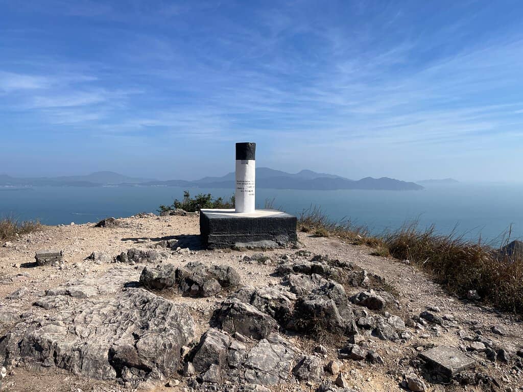
The Summit Panorama
Sharp Peak Summit
Breathtaking 360-degree views of Sai Kung's coastline, islands, and beaches. A true reward for the challenging climb.
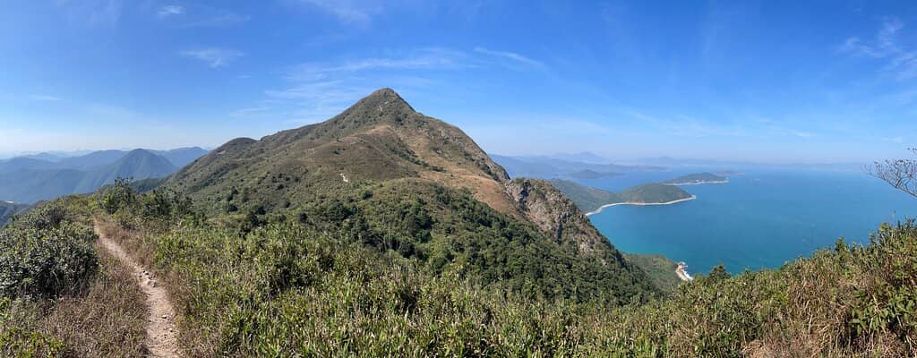
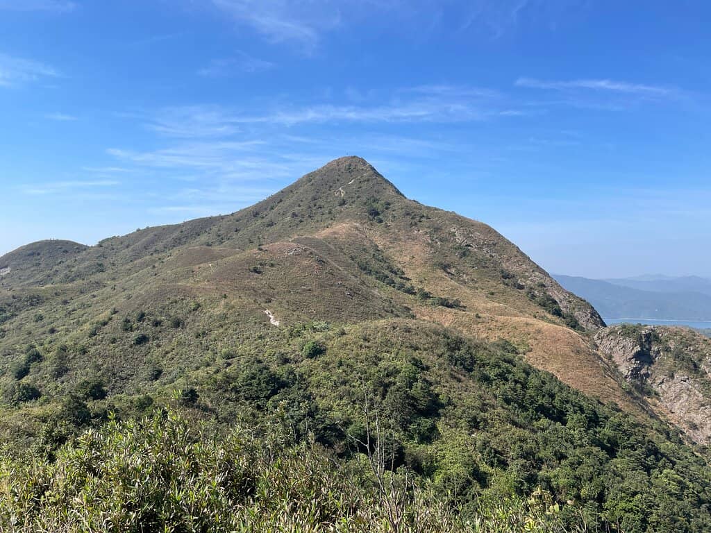
Steep Ascent Path
Sharp Peak Path
The iconic, steep, and rocky trail that tests your balance and climbing skills. An adventure in itself.
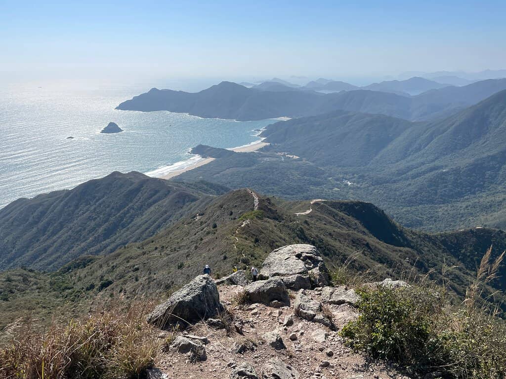
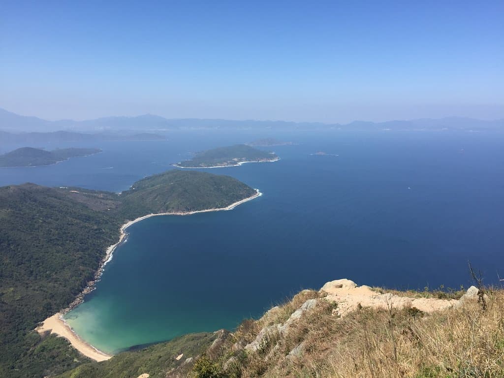
Coastal Scenery
Trail between Pak Tam Au and Sharp Peak
Dramatic views of Tai Wan beach and Chek Keng Hau Harbour along the route. Serene and natural beauty.
Plans like a pro.
Thinks like you
Planning Your Visit
Tackle the Terrain Wisely
Plan Your Transport & Timing
Best Times
Insider Tips
from TikTok, Instagram & Reddit
👟 Sturdy Footwear is Key
Wear proper hiking shoes with good grip. The trails are rocky and sandy, and the descent is slippery.
🧤 Gloves for Grip
Bring gloves for extra grip when climbing up or down steep, rocky sections.
☀️ No Shade - Go Early
The trail has no shade. Start early to avoid the midday sun and heat.
💧 Hydration is Crucial
Carry plenty of water, especially on hot days. There are no facilities along the trail.
Tips
from all over the internet
👟 Sturdy Footwear is Key
Wear proper hiking shoes with good grip. The trails are rocky and sandy, and the descent is slippery.
🧤 Gloves for Grip
Bring gloves for extra grip when climbing up or down steep, rocky sections.
☀️ No Shade - Go Early
The trail has no shade. Start early to avoid the midday sun and heat.
💧 Hydration is Crucial
Carry plenty of water, especially on hot days. There are no facilities along the trail.
🚤 Boat Return Option
Consider a boat from a beach back to Sai Kung Pier for a quicker exit. Negotiate price beforehand.
⚠️ Heed Warning Signs
Pay attention to warning signs, especially on the steepest sections. Safety first!
What Travellers Say
Reviews Summary
Sharp Peak is lauded as a must-do hike for its absolutely stunning panoramic views, offering a 5-star scenic reward. However, it's a challenging and potentially dangerous trail, requiring good balance, fitness, and proper gear. The steep, slippery, and exposed nature means hikers must be well-prepared and cautious, especially on the descent.
"A must go hiking spot. Fantastic view but a bit challenging. You need to climb and good balance skill. A 5 Stars difficulty hiking trail with 5 Stars scenic view."
Sally Cheung
"Sharp Peak, Saikung
This is one of the toughest hiking and dangerous route of HKSAR.
The total distance from Uk Tau to sharp Peak is 6.6 Km passing through Tokwapeng to MacleHose trail 2 to Dalangao, Nam She Tsim then sharp Peak (eleation 440M ) via Sharp Peak Path.
The section from Emergency phone near the MacleHose trail 2 near the Chek Keng Pier to Nam She Tsim was already quite strenuous as it was continuing rising 240 M for about a length of slope of 2.30 Km. According to the Google map the reference time required for the stated 6.6 Km is estimated to be 2 hours but for us, we took about 5 hours to Nam She Tsim and some length of Sharp Peak Path (800M short of the Sharp Peak , Destination). Coming back down to our starting point at UK Tau took another 3 hours. So, the slow walkers took 8 hours to cover 11.60 KM. In the steep slope, up hill section (Dalangao to Nam She Tsim), the path was narrow ,sandy and rocky. From Dalangao to Nam She Tsim and about 200 meters beyond ,we saw three warning Signs asking hikers to Halt. Considering there would be another 800M of very steep slope and bad soil to tackle ,very tired and another about 5.80KM for return walk to UK Tau at the starting point to catch public transport ,we stopped at the last warning sign on Sharp Peak Path.
The scenery was very serene and natural. The right hand side was the Tai Wan’s beautiful beach, whilst the Chek Keng Hau Harbour was on the left.
It worths one’s while to hike this route provided one is skilled, strong, equipped and walk on a cooler weather and on a dry weather day. Very importantly, one must be very careful about dangers of falling down.
There are public transport from Saikung Number 7 minibus or Number 94 and 96R buses(KMB, on public holidays).
Written on 7th October, 2020."
kam-ling CHIU
"Fantstic scenery at the top of Sharp Peak overlooking the beaches.
Start off at Pak Tam Au.
Going up is quite difficult on a sunny day.
Going down is even more terrifying as the roads are super slippery, I slipped twice.
But u end up on the beaches which is kind of a reward for finishing this 5 star steepest trail in HK.
We left by the boat on the beach $160 one way to Sai Kung Pier."
Lulu Lu
What People Like
What People Dislike
Frequently Asked Questions
🚇 🗺️ Getting There
The most common starting point is Pak Tam Au. Take the MTR to Diamond Hill Station (Exit C2) and catch bus 94 or 96R to Pak Tam Au. +2
Buses 94 and 96R from Diamond Hill MTR station are the primary public transport options to reach the Pak Tam Au trailhead for Sharp Peak. +2
From Sai Kung Pier, you can take minibus 7 to Pak Tam Au. Alternatively, buses 94 and 96R also serve this route.
While there might be limited parking near Pak Tam Au, public transport is generally recommended due to potential parking challenges and the popularity of the route.
Begin your hike from the Pak Tam Au bus stop. Follow the main path, and you'll eventually reach the trailhead for Sharp Peak.
🎫 🎫 Tickets & Entry
Sharp Peak is part of the Sai Kung Country Park, which is free to enter. There are no admission fees for the hiking trails themselves.
As a natural hiking trail within a country park, Sharp Peak is accessible 24/7. However, hiking during daylight hours is strongly advised for safety.
No, booking tickets is not required for Sharp Peak. It's an open hiking trail.
No special permits are required for hiking Sharp Peak. It's a public hiking trail within the Sai Kung Country Park.
Sharp Peak is considered a challenging, 5-star difficulty hike due to its steepness, rocky terrain, and exposure.
🎫 🧭 Onsite Experience
The hike can take anywhere from 4 to 8 hours round trip, depending on your fitness level and pace. Some sections are very strenuous.
Wear sturdy hiking shoes with good grip, comfortable athletic clothing, and consider bringing gloves for climbing.
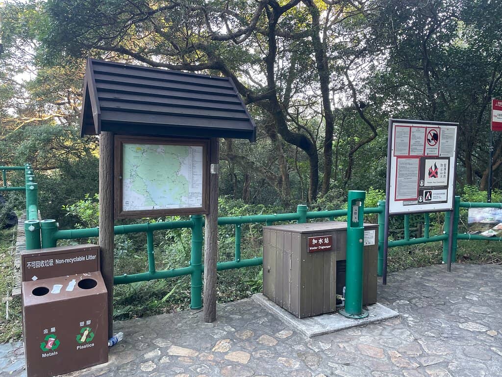
There are very limited facilities. Basic restrooms might be available near the trailhead at Pak Tam Au, but no amenities are on the peak itself.
Yes, Sharp Peak is considered one of the most dangerous hikes in Hong Kong due to steep drops, slippery surfaces, and exposure. Extreme caution is advised.
Sharp Peak has an elevation of approximately 440 meters (1,444 feet).
📸 📸 Photography
The summit offers incredible panoramic views. The steep, rocky sections of the trail also make for dramatic photos.
Sunrise or sunset can offer beautiful lighting, but be mindful of the difficulty of hiking in the dark. Mid-morning or late afternoon can also provide good light without extreme heat.
Drone usage may be restricted in country parks. It's best to check the latest regulations from the Agriculture, Fisheries and Conservation Department (AFCD) before flying.
A wide-angle lens is great for capturing the expansive views. A sturdy camera bag and protection from dust and sweat are also advisable.
The views of Tai Wan beach and Chek Keng Hau Harbour along the trail offer beautiful photographic moments before reaching the summit.
For Different Travelers
Tailored advice for your travel style
👨👩👧 Families with Kids
If your family enjoys hiking, consider exploring other, more accessible trails in Sai Kung Country Park that offer beautiful scenery without the extreme difficulty of Sharp Peak. For instance, trails around Ham Tin Wan or Tai Long Wan offer stunning coastal views with less challenging terrain.
💰 Budget Travelers
To save money on the return journey, consider hiking back to Pak Tam Au to catch the bus. While boat rides from the beaches are convenient, they can be expensive. Planning your return via public transport will significantly reduce your overall expenses for this adventure.
💪 Experienced Hikers & Adventurers
Consider combining Sharp Peak with other hikes in the Sai Kung area for a multi-day trekking experience. The ability to navigate challenging terrain and manage risks is essential. Remember to pack appropriately, including sturdy gear, ample water, and a first-aid kit.
Deep Dives
In-depth insights and expert knowledge
Navigating the Trail: From Pak Tam Au to the Peak
As you approach the summit, the trail becomes significantly steeper and more exposed. This is where the 'Sharp Peak Path' truly earns its name. Hikers often describe this section as requiring climbing skills and good balance. There are warning signs posted in these areas, indicating the increased risk. It's crucial to assess your capabilities and the conditions before proceeding on the final, most challenging ascent.
The scenery along the route is a major draw, with the sparkling waters of Tai Wan beach on one side and the Chek Keng Hau Harbour on the other. This natural beauty provides a stunning backdrop, even as you navigate the challenging terrain.
Safety and Preparedness: Essential for Sharp Peak Hikers
Given the lack of shade, sun protection and hydration are critical. Carry ample water, as there are no facilities on the trail. Starting early in the morning is advisable to avoid the harshest sun and heat. The weather can also change, so checking the forecast and being prepared for wind, especially at the summit, is wise.
Several hikers have noted the presence of warning signs on the steeper sections, urging caution. It's vital to respect these signs and your own limits. If you're not an experienced hiker or are uncomfortable with heights and steep climbs, this trail might be too demanding. The descent is often described as more terrifying than the ascent due to the slippery conditions.
The Sai Kung Coastal Reward: Beaches and Boat Rides
Many hikers choose to exit via one of the beaches, such as Hap Mun Bay. From these beaches, you can arrange for a boat ride back to Sai Kung Pier. This can be a faster and more scenic way to conclude your adventure, though it comes at a cost. Negotiating the price beforehand is recommended.
This combination of a challenging mountain hike followed by a relaxing beach and boat ride makes Sharp Peak a popular choice for those seeking an adventurous day out in Hong Kong's natural landscapes.
Social
from TikTok, Instagram & Reddit