
Blátindur
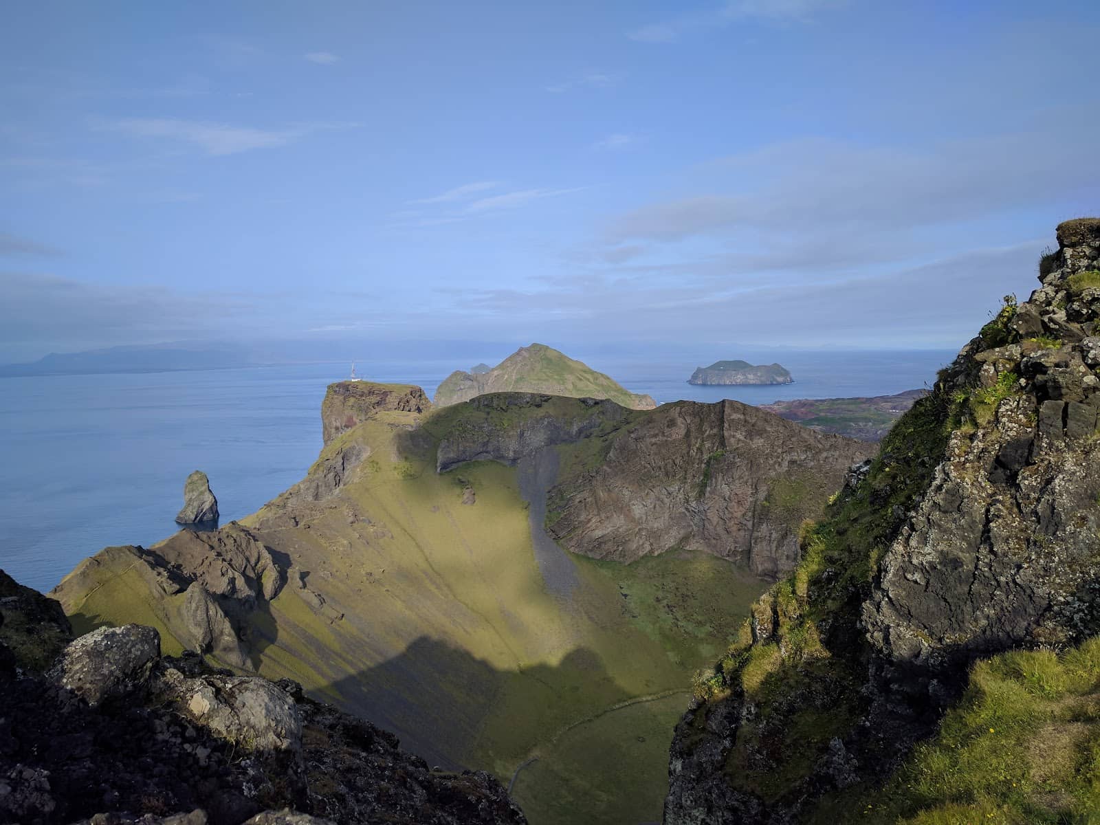
Hike to the summit of Blátindur for breathtaking panoramic views of Heimaey and witness the dramatic remnants of the 1973 Eldfell eruption.
Highlights
Must-see attractions

Social
From TikTok & Reddit
Best Time
Less wind, clearer views
Blátindur
Best Time
Less wind, clearer views
Highlights
Must-see attractions
Hike to the summit of Blátindur for breathtaking panoramic views of Heimaey and witness the dramatic remnants of the 1973 Eldfell eruption.
"The walk to the top of Blátindur is absolutely stunning. It takes a bit of effort, but it's worth it for those jaw-dropping views alone."

🥾 Sturdy Hiking Boots Needed
Essential for the steep, rocky, and loose gravel paths. Don't underestimate the terrain!
🌬️ Watch Out for Wind
The ridge can be dangerous in high winds. Check forecasts before you go.

Highlights
Discover the most iconic attractions and experiences
Panoramic Island Views
Summit of Blátindur
Jaw-dropping vistas of Heimaey, surrounding islets, and distant volcanoes. Worth every step!
Eldfell Eruption Remnants
Base of Blátindur
See a house facade almost entirely buried by lava from the 1973 eruption.
Challenging Ridge Hike
Final ascent to summit
A thrilling, steep climb over rocky terrain with incredible rewards.
Plans like a pro.
Thinks like you
Planning Your Visit
Tackle the Steep Ascent
Witness Volcanic History
Best Times
Insider Tips
from TikTok, Instagram & Reddit
🥾 Sturdy Hiking Boots Needed
Essential for the steep, rocky, and loose gravel paths. Don't underestimate the terrain!
🌬️ Watch Out for Wind
The ridge can be dangerous in high winds. Check forecasts before you go.
📸 Capture Epic Views
Bring your camera for stunning panoramic shots of the island and ocean. +1
🚶♀️ Hike with Caution
The track isn't marked, and the final ascent is steep and requires careful footing.
Tips
from all over the internet
🥾 Sturdy Hiking Boots Needed
Essential for the steep, rocky, and loose gravel paths. Don't underestimate the terrain!
🌬️ Watch Out for Wind
The ridge can be dangerous in high winds. Check forecasts before you go.
📸 Capture Epic Views
Bring your camera for stunning panoramic shots of the island and ocean. +1
🚶♀️ Hike with Caution
The track isn't marked, and the final ascent is steep and requires careful footing.
🏠 Witness History
Explore the remnants of a house buried by the 1973 eruption for a powerful reminder.
What Travellers Say
Reviews Summary
Visitors rave about the absolutely stunning and jaw-dropping views from Blátindur, making the challenging hike well worth the effort. The historical significance of the eruption remnants adds a unique dimension to the experience. However, some caution that the unmarked, steep, and rocky paths, especially the final ridge, can be difficult and dangerous, particularly in windy conditions or for those with vertigo.
"The walk to the top of Blátindur is absolutely stunning. It takes a bit of effort, but it's worth it for those jaw-dropping views alone. The track is not marked, there are some very steep sections and you have to be prepared to crawl on hands and feet on rocky paths. I wrote a description on my blog Wilderness Coffee & Natural High, to help you decide whether or not this is for you. It includes lots of pictures of the track, and the views! You can find it if you search for 'The walking track to Blátindur - The dazzling heights of Dalfjall' (wildernesscoffee-naturalhigh)."
Wilderness Coffee & Natural High
"Great hike. Bit on the foot but very ebjoyable. The view is spetacular. Just be careful when walking the loose gravel and steep parts."
Heidar Hinriksson
"A nice and short hike"
Fabian
What People Like
What People Dislike
Frequently Asked Questions
🚇 🗺️ Getting There
Blátindur is located on Heimaey island, part of the Westman Islands. You'll need to take a ferry or flight to Heimaey. From the town, it's accessible by car or a longer walk to the trailhead.
Limited parking may be available near the base of the mountain. It's advisable to arrive early, especially during peak season.
Yes, you can hike to the trailhead from Vestmannaeyjar town, though it will add to your overall journey time.
The most common way is by ferry from Landeyjahöfn on the mainland. Flights are also available from Reykjavík.
While there are some local buses, they may not directly serve the Blátindur trailhead. Renting a car or cycling are popular options.
🎫 🎫 Tickets & Entry
No, access to Blátindur and its hiking trails is generally free and open 24/7.
As an outdoor natural attraction, Blátindur is accessible at any time. However, hiking during daylight hours is recommended for safety.
The site showcasing the remains of the house affected by the 1973 eruption is free to visit.
Guided tours are not mandatory, but they can offer valuable insights into the geology and history of the area.
Be mindful of the terrain and weather conditions. It's a natural environment, so respect the landscape.
🎫 🧭 Onsite Experience
The hike itself is relatively short, often taking around 1-2 hours round trip, depending on your pace and how long you spend at the summit.
The hike is considered moderate to challenging due to steep sections and loose gravel. Beginners should be cautious and prepared.
Wear sturdy hiking boots, layers of clothing, and be prepared for changing weather. Waterproofs are advisable.
There are no facilities like restrooms or visitor centers directly at the trailhead or summit. Come prepared.
The steep and rocky final ascent may not be suitable for very young children or those with mobility issues. Assess the conditions carefully.
📸 📸 Photography
The summit offers incredible panoramic views. Don't miss capturing the dramatic landscape and the remnants of the eruption. +1
Drone regulations can vary. Always check local rules before flying. Some drone footage has been shared online.
Golden hour (early morning or late afternoon) can provide beautiful light, but clear daytime conditions offer the best visibility for expansive shots.
Yes, the historical site of the buried house is a unique and poignant subject for photography.
A wide-angle lens is great for landscapes, and a telephoto lens can capture distant details. A sturdy tripod is helpful for low light.
For Different Travelers
Tailored advice for your travel style
👨👩👧 Families with Kids
Consider focusing on the lower parts of the hike or the area around the eruption remnants for a more accessible experience. The stunning scenery is still enjoyable from the base, and the story of the eruption is captivating for all ages. Ensure everyone has appropriate footwear and is prepared for the elements.
⛰️ Adventure Seekers
Combine your visit with other hikes on Heimaey, such as Heimaklettur or Molda, to create a full day of exploration. The dramatic volcanic landscape provides ample opportunities for photography and a deep connection with Iceland's raw natural power.
Deep Dives
In-depth insights and expert knowledge
The 1973 Eldfell Eruption: A Town Transformed
This eruption not only reshaped the land but also spurred innovation. The volcanic heat was harnessed to provide hot water and heating for the town, a testament to human adaptability in the face of nature's fury. Exploring the area around Blátindur allows you to connect with this history, understanding the immense power of volcanic activity and the enduring spirit of the community. It's a stark contrast to the vibrant life that now thrives on the island.
Hiking Blátindur: A Rewarding Challenge
Despite the challenging sections, the effort is more than compensated by the spectacular panoramic views from the top. Hikers are treated to breathtaking vistas of Heimaey, the surrounding ocean, and on clear days, the mainland's dramatic coastline and volcanoes like Eyjafjallajökull. Many describe the view as 'jaw-dropping' and 'worth every step.'


Social
from TikTok, Instagram & Reddit