
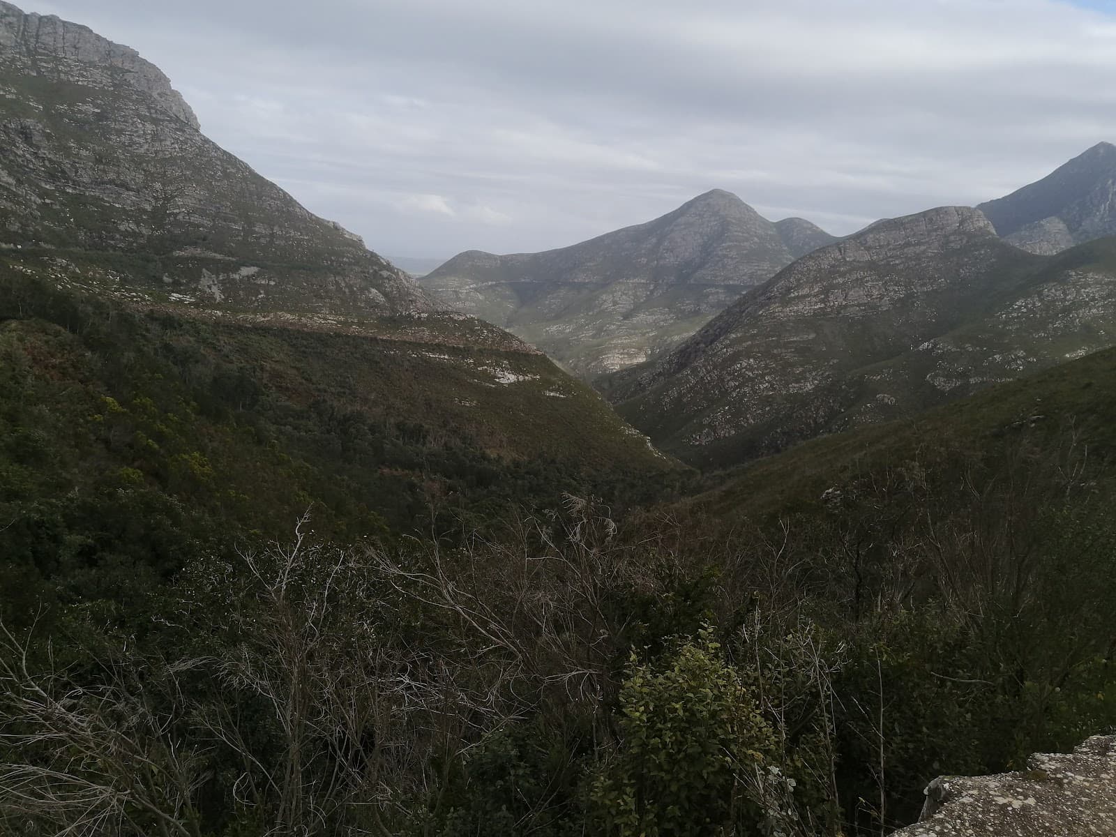
Cradock Peak
The highest peak in the Outeniqua Mountains, offering a challenging ascent and breathtaking panoramic views.
Highlights
Must-see attractions

Social
From TikTok & Reddit
Best Time
Beat the heat and crowds
Cradock Peak
Best Time
Beat the heat and crowds
Highlights
Must-see attractions
The highest peak in the Outeniqua Mountains, offering a challenging ascent and breathtaking panoramic views.
"Absolutely incredible hike but very challenging."

💪 Pack Plenty of Water
Crucial for this challenging hike! No water sources on the mountain. Aim for 3-4 liters per person.
👟 Sturdy Hiking Boots
Essential for steep gradients and rocky scrambles. Protect your ankles and get good grip.

Quick Facts
Hours
Rating
5 · 26 reviews
Type
Hiking Area
Highlights
Discover the most iconic attractions and experiences
Summit of Cradock Peak
Outeniqua Mountains
Reach the highest point of the Outeniqua range for breathtaking panoramic views. A true test of endurance.
George Peak Crossing
Between George Peak and Cradock Peak
The challenging traverse between George Peak and Cradock Peak offers a rewarding sense of accomplishment.

Vertical Kilometer Route
Ascent to George Peak
Experience a steep, rewarding climb with significant elevation gain, often part of a longer circuit.
Plans like a pro.
Thinks like you
Planning Your Visit
Prepare for a Challenging Ascent
Hydration is Key
Best Times
Insider Tips
from TikTok, Instagram & Reddit
💪 Pack Plenty of Water
Crucial for this challenging hike! No water sources on the mountain. Aim for 3-4 liters per person.
👟 Sturdy Hiking Boots
Essential for steep gradients and rocky scrambles. Protect your ankles and get good grip.
☀️ Check Weather Forecast
Mist can obscure views and make the trail treacherous. Be prepared for changing mountain conditions.
⏰ Start Early
Allow 9-11 hours for the hike. An early start helps you avoid the midday sun and finish before dark.
Tips
from all over the internet
💪 Pack Plenty of Water
Crucial for this challenging hike! No water sources on the mountain. Aim for 3-4 liters per person.
👟 Sturdy Hiking Boots
Essential for steep gradients and rocky scrambles. Protect your ankles and get good grip.
☀️ Check Weather Forecast
Mist can obscure views and make the trail treacherous. Be prepared for changing mountain conditions.
⏰ Start Early
Allow 9-11 hours for the hike. An early start helps you avoid the midday sun and finish before dark.
🧗♀️ Be Ready for Scrambling
Some sections involve easy rock climbing and boulder scrambling. Those with vertigo should be aware.
What Travellers Say
Reviews Summary
Cradock Peak is lauded as an absolutely incredible, albeit very challenging, hike with breathtaking views. While the demanding terrain and long duration are frequently mentioned, the sense of accomplishment and the stunning natural beauty make it a highly rewarding experience for those who are well-prepared and fit.
"Absolutely incredible hike but very challenging. The hike from Witfontein to the top and back is about 18km with a 1600m ascent. Time it takes is around 10 hours if you include a few breaks.
Enough water is a must. There is no accessible drinkable water on the mountain and many people suffer from dehydration. Don't underestimate the hike, it's tough."
Tyran Bester
"Cardo pig is an absolute mass for hiking enthusiast the trails challenging but rewarding often breathtaking views of the 18 mountains and the surrounding landscapes however when we did the hike it was very misty so make sure to check the weather if you go I do suggest taking the right gear Especially if you are planning on doing the food trail we turned around halfway due to the mist but it was still very beautiful and a great experience!!"
Jo-anne van Niekerk
"This is the best milestone any friends family. So many beautiful flowers to see . It is also thee best place to bond over pain . It is really far , but worth every meter on the trail .Absolutely breathtaking"
Leonex Ntando
What People Like
What People Dislike
Frequently Asked Questions
🚇 🗺️ Getting There
The most common starting point is Witfontein Forestry Station. From there, you'll follow forest roads through pine plantations to reach the base of the Outeniqua Mountains and the trailhead for Cradock Peak.
You can drive to Witfontein Forestry Station, which serves as the trailhead. The hike itself is not accessible by vehicle.
The closest major town is George, located in the Western Cape province of South Africa.
Public transport options to Witfontein Forestry Station are limited. It's generally recommended to have your own vehicle or arrange a private transfer.
The roads leading to Witfontein are typically forest roads. While generally manageable, conditions can vary, especially after rain.
🎫 🎫 Tickets & Entry
There are no specific entry tickets required for hiking Cradock Peak itself. However, access might be managed by forestry or park authorities, so it's wise to check for any local regulations or potential fees.
As a natural hiking trail, Cradock Peak doesn't have set opening hours. However, it's advisable to start your hike during daylight hours for safety and visibility.
Typically, there isn't a direct entrance fee for the hiking trails. However, parking or access to the forestry areas might incur a small charge.
While not always advertised, local tour operators in the George area may offer guided hikes. Booking in advance is recommended if you prefer a guided experience.
Generally, no specific hiking permits are required for day hikes. However, for overnight stays or specific activities, permits might be necessary. Always check with local authorities.
🎫 🥾 Onsite Experience
The hike from Witfontein to the summit and back typically takes 9-11 hours, including breaks. Some ambitious hikers complete it faster, while others take longer. +1
It's considered a challenging hike due to steep gradients and significant elevation gain (around 1600m ascent). A good level of fitness is required. +1
Wear sturdy hiking boots with good grip, comfortable moisture-wicking clothing, and layers for changing weather. A hat and sunscreen are also recommended.
Facilities at Witfontein Forestry Station are basic. There are usually no restrooms or shops, so come prepared with everything you need.
Due to its challenging nature and length, Cradock Peak is generally not recommended for absolute beginners. Experienced hikers with good fitness will enjoy it more.
🍽️ 🍎 Food & Dining
No, there are no dining facilities on Cradock Peak. You must carry all your food and snacks with you for the hike.
Pack energy-rich snacks like trail mix, energy bars, fruit, and sandwiches. Ensure you have enough food to sustain you for 9-11 hours.
After your hike, you can find various restaurants and cafes in the nearby town of George, offering a range of dining options.
It is strongly advised not to forage for food. Stick to what you have packed to ensure safety and avoid potential risks.
Yes, you can have a picnic, but remember to pack out everything you pack in to keep the mountain clean. Choose a scenic spot to enjoy your meal.
📸 📸 Photography
The summit offers incredible panoramic views. Sunrises and sunsets from the higher reaches can be spectacular, as can the diverse mountain landscapes.
A wide-angle lens is great for landscapes. A telephoto lens can capture distant details. Consider a lightweight setup as you'll be carrying it for hours.
Drone regulations can vary. It's essential to check with local authorities or park management regarding drone usage to avoid penalties.
Early morning and late afternoon offer the best light for photography, with softer shadows and warmer tones.
Include a person in your shots to give a sense of scale. Wide-angle shots from the summit can also emphasize the vastness of the landscape.


Social
from TikTok, Instagram & Reddit