
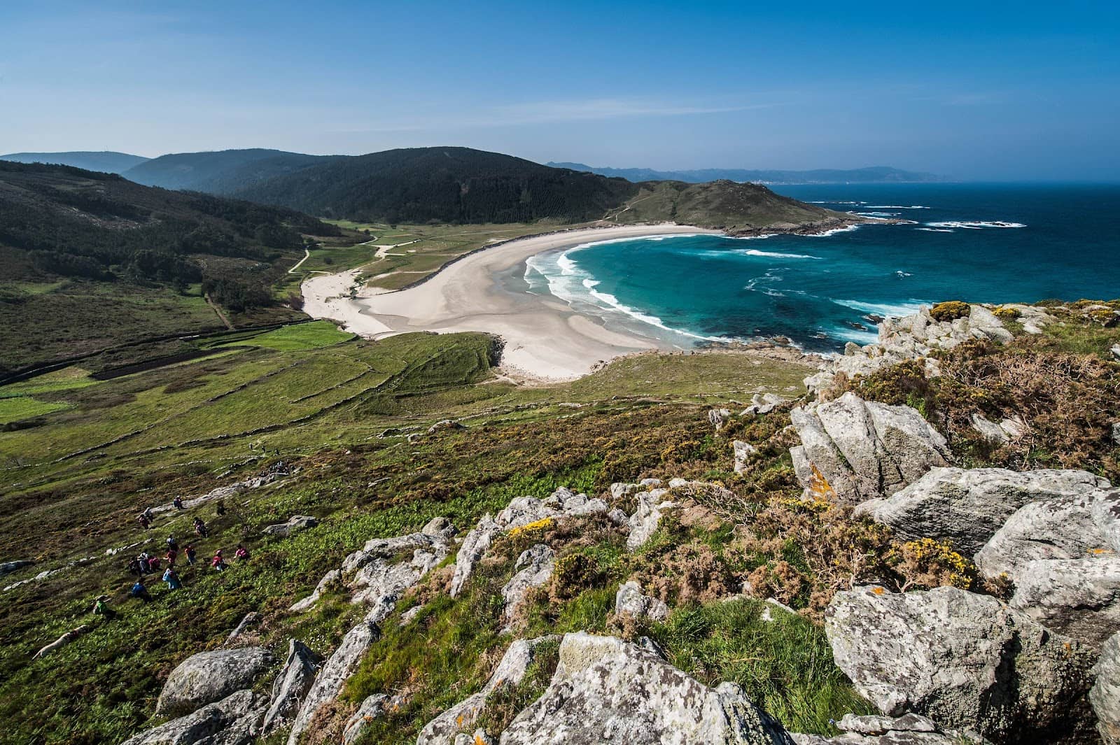
Camiño dos Faros Lires-Fisterra
A rugged coastal trail along the Costa da Morte, culminating at the historic 'End of the World' in Fisterra.
Highlights
Must-see attractions

Social
From TikTok & Reddit
Best Time
Surprising blooms, fewer crowds
Camiño dos Faros Lires-Fisterra
Best Time
Surprising blooms, fewer crowds
Highlights
Must-see attractions
A rugged coastal trail along the Costa da Morte, culminating at the historic 'End of the World' in Fisterra.
"Beautiful route with a certain physical effort, rewarded with splendid views."

💪 Pack for a Challenge
Terrain is varied and can be slippery. Good hiking boots and trekking poles are essential for this demanding route.
📍 Don't Skip GPS
Trail signs can be approximate. A GPS device or reliable navigation app is highly recommended to stay on track.
Quick Facts
Highlights
Discover the most iconic attractions and experiences
Praia de Lires
Lires
A beautiful white sand beach where the Castro River meets the sea, offering a serene start or end point.
Dramatic Coastal Cliffs
Various points along the route
Experience breathtaking ocean vistas and rugged cliffs that define the wild Costa da Morte.

Faro de Fisterra
Fisterra
The iconic lighthouse marking the historical 'end of the world,' offering panoramic views and a profound sense of arrival.
Plans like a pro.
Thinks like you
Planning Your Visit
Prepare for a Coastal Challenge
Embrace the 'End of the World'
Best Times
Insider Tips
from TikTok, Instagram & Reddit
💪 Pack for a Challenge
Terrain is varied and can be slippery. Good hiking boots and trekking poles are essential for this demanding route.
📍 Don't Skip GPS
Trail signs can be approximate. A GPS device or reliable navigation app is highly recommended to stay on track.
🏨 Book Stays Ahead
Accommodation can be limited, especially in smaller villages. Booking in advance is wise, particularly outside peak season.
🌊 Embrace the Wild Coast
The route offers intense, beautiful coastal trails. Be prepared for stunning, sometimes dramatic, ocean views.
Tips
from all over the internet
💪 Pack for a Challenge
Terrain is varied and can be slippery. Good hiking boots and trekking poles are essential for this demanding route.
📍 Don't Skip GPS
Trail signs can be approximate. A GPS device or reliable navigation app is highly recommended to stay on track.
🏨 Book Stays Ahead
Accommodation can be limited, especially in smaller villages. Booking in advance is wise, particularly outside peak season.
🌊 Embrace the Wild Coast
The route offers intense, beautiful coastal trails. Be prepared for stunning, sometimes dramatic, ocean views.
🍽️ Enjoy Local Flavors
Villages along the way offer great places to eat. Enjoy fresh local cuisine after a day of hiking.
What Travellers Say
Reviews Summary
This coastal trek is lauded for its stunning, wild beauty and the sense of accomplishment it provides. While challenging with varied terrain and significant elevation changes, hikers are rewarded with breathtaking views and a less-touristed experience. Booking accommodation and using GPS are highly recommended for a smoother journey.
"Beautiful route with a certain physical effort. There are no technically difficult passages but the terrain is varied, with sections that are not perfectly marked and with slippery, rocky and irregular surfaces in several places and non-trivial differences in height.
That said, for those who are used to medium-difficulty excursions in the mountains, it is a trek with difficulty E and very few EE sections (expert hikers) mostly due to the length of the stages (an average of 20km), positive differences in height of 700-1,000 meters and the somewhat approximate trail signs.
You will be rewarded with splendid views, surprising spring blooms and a few villages not yet invaded by overtourism.
I recommend booking accommodation and a GPS..."
Antonio Pistore
"Fabulous experience. A tough but beautiful journey."
Ursula nieto gonzalez
"Beautiful"
David Alberto Fontán Romero
What People Like
What People Dislike
Frequently Asked Questions
🚇 🗺️ Getting There
The most common starting point for this section is Lires. You can reach Lires by bus from nearby towns like Cee or Fisterra, though services might be infrequent. Many hikers opt to start their journey from Fisterra and walk towards Lires, or arrange private transport. +1
Yes, you can walk from Santiago to Finisterre and Muxia. The Camiño dos Faros is a coastal route that can be incorporated after completing the traditional Camino de Santiago routes.
You can walk between Fisterra and Muxia, or use local bus services. The coastal walk is highly recommended for its scenic beauty.
Public transport is limited along the more remote sections of the Camiño dos Faros. Buses connect major towns like Fisterra, Cee, and Muxia, but may not serve every trailhead directly. +1
Absolutely! The Camiño dos Faros is a network of stages, and you can choose to start or end at various points like Lires, Fisterra, or Muxia, depending on your itinerary and fitness level. +1
🎫 🎫 Tickets & Entry
No, the Camiño dos Faros is a public hiking trail and does not require any tickets or entry fees. You can access it freely. +1
As an outdoor trail, the Camiño dos Faros is accessible at all times. However, it's advisable to hike during daylight hours for safety and enjoyment.
Yes, guided tours are available, particularly for specific stages like the Lires to Faro de Fisterra section. These often include logistical support and local insights. +1
No permits are required to hike the Camiño dos Faros. It's an open-access coastal path.
Booking accommodation in advance is highly recommended, especially during peak seasons. You can use online booking platforms or contact local guesthouses directly.
🎫 🧭 Onsite Experience
This section is considered medium to high difficulty, with technical sections. It involves significant elevation changes (around 1300m for 37km) and varied, sometimes slippery, terrain.
The Lires to Faro de Fisterra stage is approximately 20 km and is typically completed in a full day of hiking, around 6-8 hours depending on your pace and stops. +1
Trail marking can be approximate in some areas. While there are signs, it's wise to supplement with a GPS device or map for navigation.
Expect stunning coastal landscapes, dramatic cliffs, beautiful beaches like Praia de Lires, and charming villages. It's a true immersion in the wild Costa da Morte. +1
Due to the varied terrain, elevation changes, and potential for slippery paths, it's best suited for hikers with some experience. Beginners might find it challenging.
🍽️ 🍽️ Food & Dining
Villages like Lires and Fisterra offer restaurants and shops. It's advisable to carry sufficient water and snacks, especially for longer stretches between settlements.
You'll find excellent fresh seafood, Galician specialties like 'pulpo a la gallega' (octopus), and local wines. Enjoying the local cuisine is a highlight.
Restaurants are generally found in the villages you pass through, rather than directly on the trail itself. Plan your meal stops accordingly.
While seafood is prevalent, many restaurants offer vegetable-based dishes or can adapt meals. It's always good to ask about options.
Smaller villages may have limited shops. It's best to stock up on essentials in larger towns like Fisterra or Cee before setting out on longer sections.
📸 📸 Photography
The dramatic coastal cliffs, Praia de Lires, and the Faro de Fisterra itself offer incredible photo opportunities. Look for viewpoints overlooking the ocean. +1
Golden hour, shortly after sunrise and before sunset, provides the most dramatic light for coastal landscapes. Midday can be harsh.
A good smartphone camera is sufficient for most shots. If you're serious about landscape photography, a wide-angle lens can be beneficial.
Always check local regulations regarding drone usage, especially near coastal areas and protected natural sites.
Galicia's weather can be unpredictable. Dramatic skies with clouds can add to the moodiness of coastal photos, so embrace it!


Social
from TikTok, Instagram & Reddit