
Chinyero Circular Trail
Hike through Tenerife's dramatic 1909 volcanic eruption site, a unique landscape of lava fields and pine forests.
Highlights
Must-see attractions

Social
From TikTok & Reddit
Best Time
Avoid midday heat, enjoy cooler temps
Chinyero Circular Trail
Best Time
Avoid midday heat, enjoy cooler temps
Highlights
Must-see attractions
Hike through Tenerife's dramatic 1909 volcanic eruption site, a unique landscape of lava fields and pine forests.
"A fantastic experience on Tenerife! You can access the circular route from TF-38."

🥾 Sturdy Hiking Boots Needed
Uneven terrain with lava rocks means proper footwear is a must.
🗺️ Map Your Route
The full circle's entry/exit can be confusing; mark your map beforehand.
Highlights
Discover the most iconic attractions and experiences
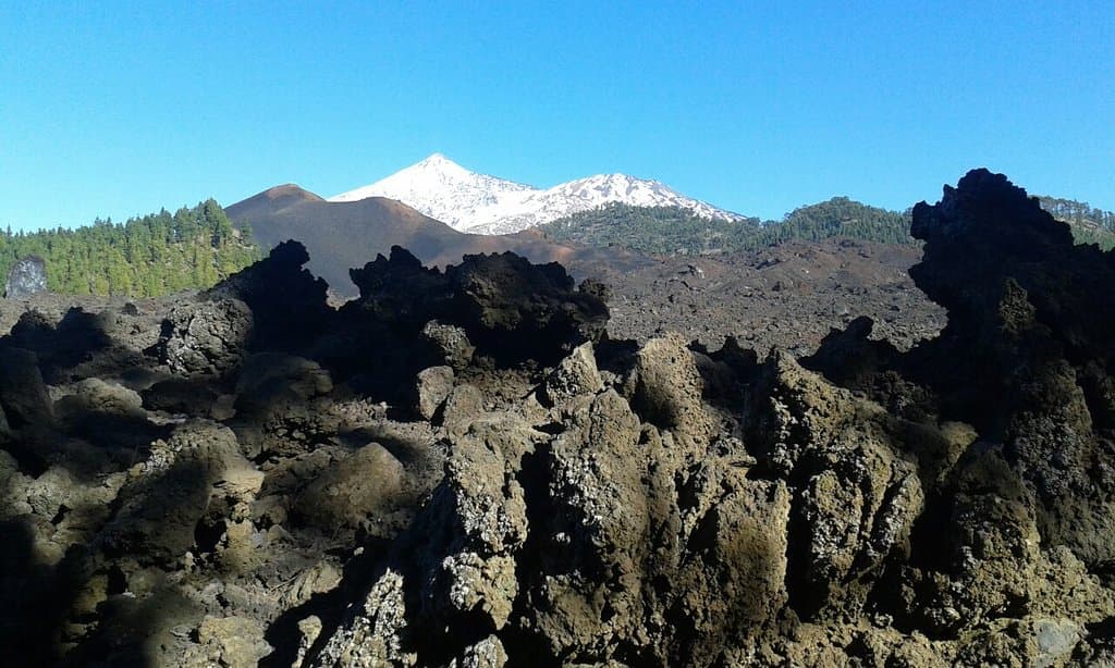
Chinyero Volcano
Summit of the trail
Witness the raw power of Tenerife's most recent eruption site from 1909. A truly unique volcanic landscape.
Lava Rock Fields
Southern section of the trail
Trek across stark, rugged lava fields, a dramatic contrast to the surrounding pine forests.

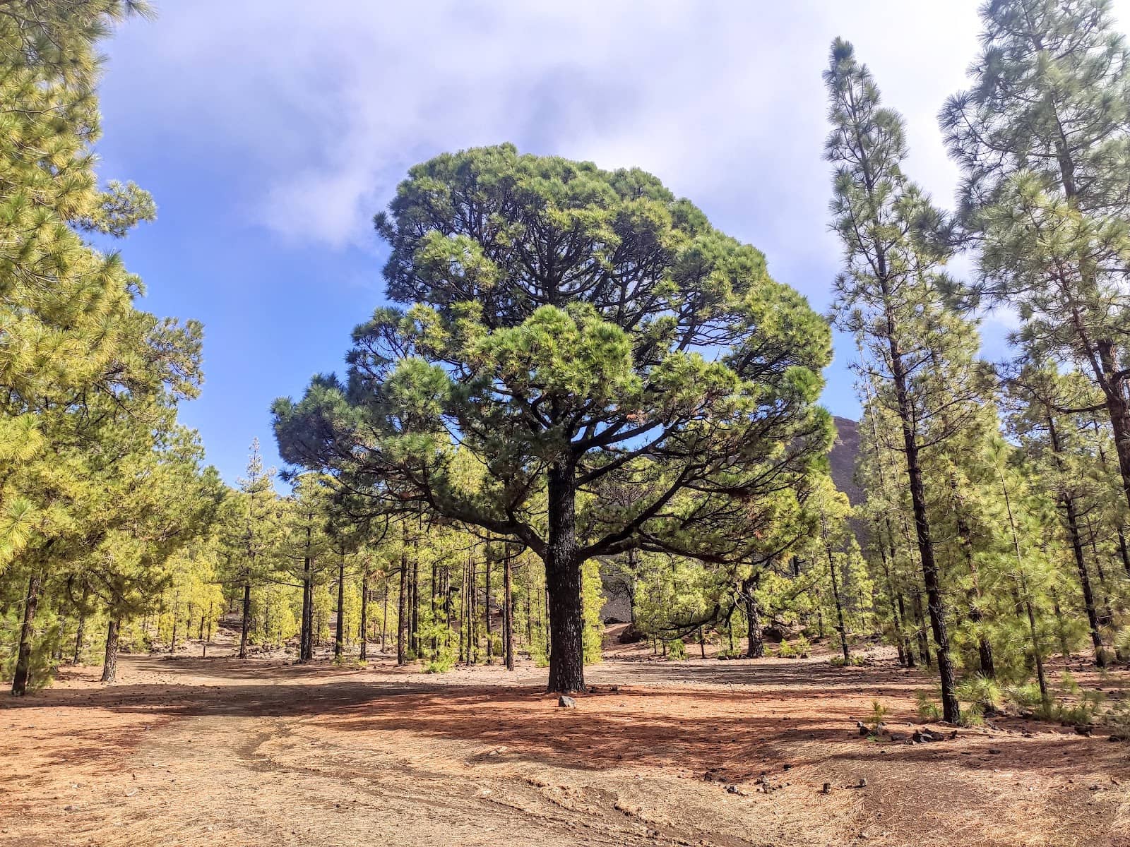
Pine Forests
Northern section of the trail
Enjoy the refreshing shade and fragrant air of the dense pine forests that dot the landscape.
Plans like a pro.
Thinks like you
Planning Your Visit
Footwear is Key
Trail Navigation Tips
Best Times
Insider Tips
from TikTok, Instagram & Reddit
🥾 Sturdy Hiking Boots Needed
Uneven terrain with lava rocks means proper footwear is a must.
🗺️ Map Your Route
The full circle's entry/exit can be confusing; mark your map beforehand.
💧 Bring Plenty of Water
Stay hydrated, especially when traversing the lava fields.
🧥 Dress in Layers
Winds can be cool and strong, even on sunny days.
Tips
from all over the internet
🥾 Sturdy Hiking Boots Needed
Uneven terrain with lava rocks means proper footwear is a must.
🗺️ Map Your Route
The full circle's entry/exit can be confusing; mark your map beforehand.
💧 Bring Plenty of Water
Stay hydrated, especially when traversing the lava fields.
🧥 Dress in Layers
Winds can be cool and strong, even on sunny days.
📸 Capture the Contrast
The trail offers dramatic shifts from lava fields to lush forests.
What Travellers Say
Reviews Summary
Visitors rave about the Chinyero Circular Trail's unique volcanic landscapes and the beautiful contrast with pine forests. Many highlight the moderate difficulty and peaceful atmosphere, making it a recommended hike for its natural beauty and geological significance. Some note that the full circular route's signage can be a bit confusing.
"It was my first hiking in the Tenerife. Amazing views. I recommend it for anyone! 😄"
Marcin Pawelec
"The Chinyero Volcano hiking trail is a fantastic experience on Tenerife! You can access the circular route from TF-38, which forms a figure-eight shape. Hikers can either complete the full loop (about 4 hours) or just the southern section (around 2 hours). Parking is limited, but there are a few more spaces in the curve a bit further down.
The official trailhead is a dirt road from La Montañeta to Arenas Negras—an off-road vehicle is recommended for this part. The shorter, 2-hour loop offers a diverse landscape, taking you through beautiful pine forests and across rugged lava rock fields. The terrain is uneven, with some ups and downs, so sure footing and sturdy hiking boots are a must—flip-flops are definitely not suitable! Also, be prepared for strong, cool winds at times, so bring appropriate clothing.
The trail is enjoyed by both young and old and is a great choice for anyone looking for a scenic and varied hike!"
Fabian Romen
"Lovely walk, through such a special landscape.
If you decide to do the 'circular' trail, it takes about 2h30 hours on a relaxed pace, a little bit of climbing here and there but nothing too serious. Plenty of shade and lovely smell of the pine forest. I do have to warn, careful when making a full circle, the 'entry/exit' is not well indicated, so before you know it you start up again the trail. I pinpointed the park entry on my maps before entering, as not to get lost :)"
Anca Gregorius
What People Like
What People Dislike
Frequently Asked Questions
🚇 🗺️ Getting There
The trail is accessible from the TF-38 road. Parking is available but limited, with some additional spaces further down the road. Some suggest an off-road vehicle for the initial dirt road section from La Montañeta to Arenas Negras, though many visitors manage with standard cars.
Yes, there is parking available at the trailhead, but it can be limited, especially during peak times. It's advisable to arrive early or be prepared for a short walk from a nearby spot.
Public transport options to the immediate trailhead are very limited. It's generally recommended to have a rental car or join a guided tour for convenient access.
The trail forms a figure-eight shape. You can start from the dirt road off the TF-38. Many hikers opt for the southern section for a shorter, 2-hour loop.
The main road (TF-38) is paved. However, the initial dirt road section to the trailhead might be better suited for vehicles with higher clearance, though many visitors report no issues with standard cars.
🎫 🎫 Tickets & Entry
No, the Chinyero Circular Trail is a public hiking route and does not require any tickets or admission fees. You can access it freely.
The trail is open year-round and accessible at any time. However, it's best to hike during daylight hours for safety and to fully appreciate the scenery.
There is no entrance fee to hike the Chinyero Circular Trail. It's a free natural attraction for visitors to enjoy.
Yes, many local tour operators offer guided hikes of the Chinyero Circular Trail, which can be beneficial for understanding the volcanic history and ensuring you don't get lost.
Generally, there are no specific restrictions, but always be mindful of the natural environment. Stick to marked paths and avoid disturbing the flora and fauna.
🎫 🥾 Onsite Experience
The full circular route typically takes about 4 to 5 hours at a relaxed pace. The southern section can be completed in around 2 hours.
The trail is considered moderate. It involves some ups and downs but is generally manageable for most fitness levels. Sturdy footwear is crucial due to the uneven terrain.
While you hike through the volcanic landscape, the trail itself doesn't always offer direct, panoramic views of the Chinyero volcano's peak. However, the surrounding volcanic scenery is spectacular.
The trail is generally well-marked, but the junctions for the full circular route can be confusing. It's recommended to have a map or GPS device.
Expect a diverse landscape including pine forests, rugged lava fields, and volcanic ash. It's a unique contrast that makes the hike memorable.
🍽️ 💧 Food & Drink
There are no facilities for food or drink directly on the trail. It's essential to bring all your own water and snacks.
Pack plenty of water, especially for the full loop. Energy bars, sandwiches, and fruit are good snack options to keep you fueled.
The trail is in a relatively remote area. You'll find restaurants and cafes in nearby towns like Santiago del Teide or Puerto de la Cruz, but not immediately adjacent to the trailhead.
Picnicking is possible, but please ensure you pack out all your trash to keep the natural environment clean.
It is not recommended to drink water from natural sources on the trail due to potential contamination. Always bring sufficient bottled water.
📸 📸 Photography
The dramatic contrast between the black lava fields and the green pine forests offers stunning photographic opportunities. The unique volcanic formations are also very photogenic.
Early morning or late afternoon light provides softer shadows and more dramatic colors, enhancing the volcanic landscape's textures.
A standard camera or smartphone is sufficient. However, a wide-angle lens can be useful for capturing the expansive volcanic landscapes.
Drone regulations can vary and are often restricted in natural parks. It's best to check local regulations before flying a drone.
While direct summit views are limited, you can capture the vastness of the volcanic field and the surrounding caldera.
For Different Travelers
Tailored advice for your travel style
👨👩👧 Families with Kids
Key tips for families: Bring plenty of snacks and water, as there are no facilities on the trail. Ensure children wear appropriate footwear – sturdy trainers or hiking shoes are a must. The uneven terrain can be challenging for very young children, so consider a carrier if needed. The contrast between the dark lava and the green trees is visually stimulating and can keep younger hikers interested.
🚶♀️ Solo Hikers
Solo hiker recommendations: Inform someone of your hiking plans, including your expected return time. Carry a fully charged phone. The varied scenery, from stark lava fields to fragrant pine forests, makes for an engaging and solitary experience. It's a perfect opportunity for quiet contemplation and enjoying nature at your own pace.
🏃♂️ Trail Runners
Trail running tips: The southern loop is a popular choice for shorter runs. For longer runs, be prepared for the technical sections of the full circuit. Ensure you have adequate hydration and nutrition, as water sources are non-existent. The cooler morning or late afternoon hours are ideal for running to avoid the heat.
Deep Dives
In-depth insights and expert knowledge
Understanding the Chinyero Eruption
Hiking through this area offers a tangible connection to the island's volcanic power. The landscape is a testament to nature's ability to reclaim and transform. You'll walk over pahoehoe lava (smooth, ropy lava) and aa lava (rough, blocky lava), providing a fascinating geological lesson underfoot. The starkness of the volcanic rock is beautifully contrasted by the resilient pine forests that have begun to colonize the edges of the lava flows.
This volcanic trail is not just about the scenery; it's an educational journey. It allows visitors to appreciate the dynamic geological processes that have shaped Tenerife and continue to influence its landscape. The Chinyero Circular Trail offers a unique opportunity to explore a relatively recent volcanic event up close.
Navigating the Chinyero Circular Trail
Key navigational advice includes downloading an offline map or using a GPS device. The trail surface varies significantly, from well-trodden paths to loose scree and uneven lava rock. This necessitates sturdy hiking boots for ankle support and grip. While the pine forest sections offer shade, the exposed lava fields can be very hot and bright, so sun protection is also important.
For those seeking a less strenuous experience, focusing on the southern loop is a great option. It still provides a fantastic taste of the volcanic terrain and the beautiful pine forests without the commitment of the full circuit. Regardless of the chosen route, taking your time to appreciate the unique environment is highly recommended.


Social
from TikTok, Instagram & Reddit