
Semáforo de Anaga Igueste
Historic maritime signaling station offering spectacular coastal views after a steep, rewarding hike.

Highlights
Must-see attractions

Social
From TikTok & Reddit
Best Time
Clearer skies, better light

Semáforo de Anaga Igueste
Best Time
Clearer skies, better light

Highlights
Must-see attractions
Historic maritime signaling station offering spectacular coastal views after a steep, rewarding hike.
"The views along the way are excellent, and at the traffic lights, they're breathtaking."
👟 Wear Sturdy Shoes
The path is steep and winding. Good grip is essential for a safe and enjoyable hike.
💧 Stay Hydrated
Bring plenty of water, especially on warmer days, as the climb can be strenuous.
Highlights
Discover the most iconic attractions and experiences

Panoramic Coastal Views
Summit of the trail
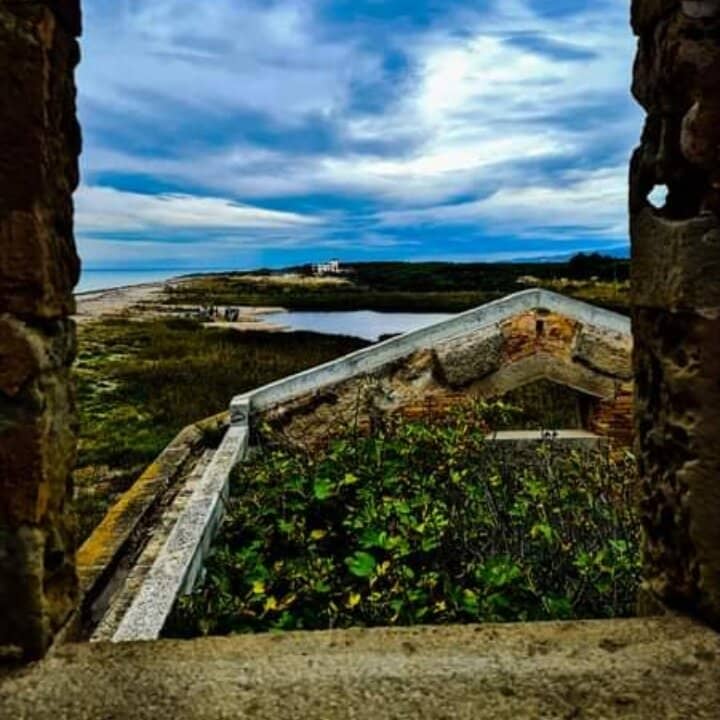
Breathtaking vistas of the rugged Anaga coastline and the Atlantic Ocean. A photographer's dream!

Historic Signaling Station
Semáforo de Anaga Igueste site
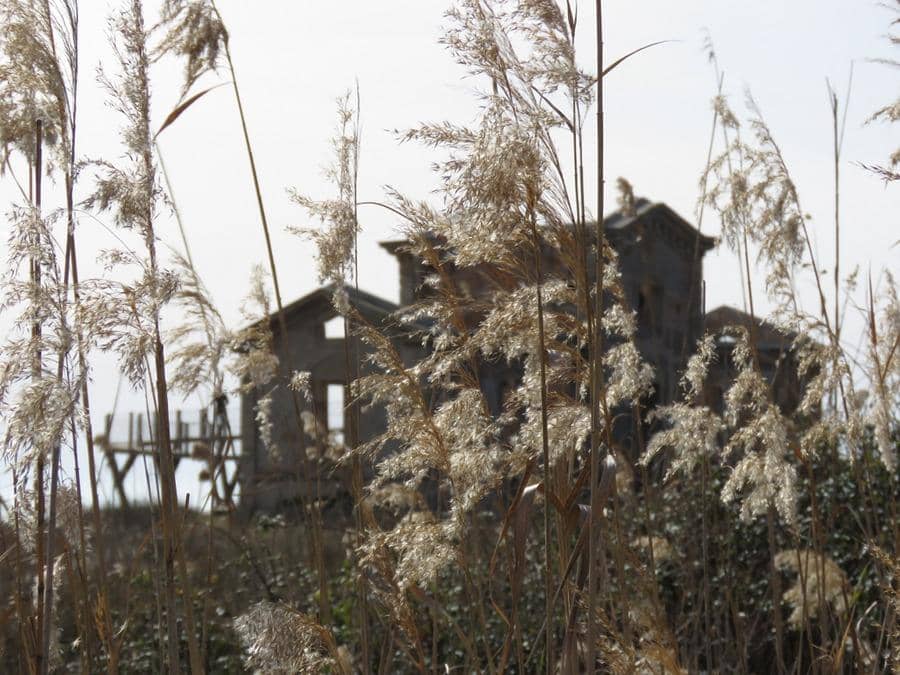
Explore the remnants of this late 19th-century maritime signaling station, operational until 1971.

Interpretive Center
Base of the site
Learn about the history and function of this iconic communication landmark.
Plans like a pro.
Thinks like you
Planning Your Visit
Timing Your Visit to Anaga's Semaphore
Navigating the Steep Ascent
Best Times
Insider Tips
from TikTok, Instagram & Reddit
👟 Wear Sturdy Shoes
The path is steep and winding. Good grip is essential for a safe and enjoyable hike.
💧 Stay Hydrated
Bring plenty of water, especially on warmer days, as the climb can be strenuous.
📸 Capture the Views
The scenery is spectacular! Don't forget your camera or phone for stunning photos.
⏳ Allow Ample Time
The 2km climb can take about an hour each way. Factor in time for enjoying the views.
Tips
from all over the internet
👟 Wear Sturdy Shoes
The path is steep and winding. Good grip is essential for a safe and enjoyable hike.
💧 Stay Hydrated
Bring plenty of water, especially on warmer days, as the climb can be strenuous.
📸 Capture the Views
The scenery is spectacular! Don't forget your camera or phone for stunning photos.
⏳ Allow Ample Time
The 2km climb can take about an hour each way. Factor in time for enjoying the views.
🚌 Check Bus Schedules
If using public transport, plan your trip around bus times to avoid long waits.
What Travellers Say
Reviews Summary
Visitors rave about the absolutely breathtaking panoramic views from the Semáforo de Anaga Igueste, calling them 'magnificent' and 'stunning.' The challenging, steep hike is considered well worth the effort for the scenery. Some note the semaphore ruins themselves are uninteresting, but the journey and vistas are the true highlights. The new Interpretive Center adds historical context.
"Departure from bus stop 945. White and yellow markings.
No particular difficulty except that the winding path is very steep. If you took the bus, making the round trip for this hike in 2 hours to catch the next bus gives you just enough time without hanging around too much. For those who are not in the necessary physical condition, you are not obliged to go all the way to the semaphore (a sort of uninteresting ruin) to enjoy a magnificent view. Just climb for about 30 minutes and you will be amazed."
christine oliveira
"A 2km steep climb. The views along the way are excellent, and at the traffic lights, they're breathtaking."
La Casita Azul De Puerto
"This trail is recommended to explore another natural area in a corner of Tenerife where you can breathe tranquility and enjoy the views."
Eneri Díaz
What People Like
What People Dislike
Frequently Asked Questions
🚇 🗺️ Getting There
The most common way to reach the Semáforo de Anaga Igueste is by public bus, typically line 945 from Santa Cruz de Tenerife. The bus will drop you off near the trailhead. From there, it's a steep, approximately 2km hike to the semaphore.
Parking options can be limited in the Anaga rural park. Relying on public transport is often recommended to avoid parking hassles.
While you can drive towards Igueste de San Andrés, the final ascent to the semaphore is a hiking trail and not accessible by car.
The trailhead is usually marked and accessible from the road leading to Igueste de San Andrés. Following signs for the Semáforo or hiking trails is advised.
While not always advertised, local tour operators in Tenerife may offer guided hikes in the Anaga region that include this site. It's worth checking with local tourism providers.
🎫 🎫 Tickets & Entry
The Semáforo de Anaga Igueste itself is an outdoor historical site and generally does not require an entrance fee. The Interpretive Center may have specific opening hours and potential entry policies.
The outdoor site is accessible at any time. However, the newly inaugurated Centro de Interpretación del Semáforo de Igueste de San Andrés has specific opening hours, which are best checked locally or on official tourism websites.
Information regarding admission fees for the Centro de Interpretación del Semáforo de Igueste de San Andrés is not widely available, but it's likely to be free or have a nominal charge, as it's a cultural heritage site.
Yes, the site is accessible year-round. However, weather conditions in Anaga can be unpredictable, so checking forecasts before your visit is recommended.
The hiking trail is generally open, but it's always wise to be aware of any temporary closures due to weather or maintenance, especially in a natural park setting.
📸 📸 Photography
The entire trail offers stunning photo opportunities. The summit provides breathtaking panoramic views of the coastline and the Atlantic. Don't miss capturing the ruins against the dramatic landscape.
Mornings often offer clearer skies and softer light, ideal for landscape photography. Late afternoons, during the golden hour, can provide dramatic lighting and long shadows.
A wide-angle lens is great for capturing the expansive views. A sturdy tripod can be useful for low-light conditions or capturing long exposures of the sea.
Drone usage in natural parks like Anaga is often restricted or requires special permits. It's best to check the regulations of the Parque Rural de Anaga before flying a drone.
The dramatic cliffs, the vast ocean, the historic semaphore ruins, and the winding trail itself are all iconic subjects.
🎫 🚶 Onsite Experience
The hike is about 2km each way and is quite steep. It typically takes around 1 hour to reach the semaphore, and another hour to descend, so budget at least 2 hours for the round trip, plus time for enjoying the views.
The trail is considered steep and challenging due to the elevation gain. It requires a moderate level of fitness.
The Semáforo itself is in ruins and lacks facilities. The Interpretive Center at the base may have restrooms and information.
You'll see the remnants of the old maritime signaling station and, most importantly, spectacular panoramic views of the Anaga coastline and the Atlantic Ocean.
The steepness of the trail might be challenging for very young children. Older children with good stamina can manage, but supervision is essential.
For Different Travelers
Tailored advice for your travel style
👨👩👧 Families with Kids
Key tips for families:
* Assess your children's fitness levels before embarking on the hike.
* Bring plenty of snacks and water to keep energy levels up.
* Consider turning back if the climb becomes too difficult for younger ones; the views lower down are still impressive.
* Focus on the journey and the views rather than solely on reaching the summit. The Interpretive Center at the base also offers educational insights.
🚶 Hikers and Nature Enthusiasts
This destination is ideal for those who appreciate historical remnants set against stunning natural backdrops. The ruins of the signaling station add a layer of intrigue to the hike. Remember to wear appropriate footwear and bring water, as the path can be demanding. The surrounding area is also known for its unique flora, making it a treat for botanically inclined visitors.
Deep Dives
In-depth insights and expert knowledge
The History of the Semáforo de Anaga
The recent inauguration of the Centro de Interpretación del Semáforo de Igueste de San Andrés aims to preserve and share this rich history. This interpretive center provides visitors with detailed insights into the station's operation, its historical significance, and its connection to the broader maritime heritage of Tenerife. It serves as an educational space, fostering a deeper understanding and appreciation for this unique landmark.
Located at approximately 220 meters above sea level on the cliff of La Atalaya, the site offers not only historical context but also stunning natural beauty. The strategic position allowed for excellent visibility, a feature that also benefits modern visitors seeking breathtaking views of the Anaga coastline and the vast Atlantic Ocean.
Hiking to the Semáforo: What to Expect
Practical advice from fellow travelers emphasizes the need for sturdy footwear due to the steep and sometimes uneven terrain. Bringing ample water is also crucial, especially during warmer months, as there are no facilities along the trail. The round trip, including time to soak in the scenery, can take approximately 2 hours, so it's important to plan your visit, particularly if you are relying on public transportation with limited schedules.
Beyond the physical exertion, the hike offers a chance to immerse yourself in the rugged natural beauty of the Anaga Rural Park. The dramatic cliffs, the scent of the coastal vegetation, and the sound of the waves below create a truly memorable experience. It's a perfect activity for those seeking both a physical challenge and spectacular natural landscapes.


Social
from TikTok, Instagram & Reddit