Caoling Historic Trail Taiwan
A historic Qing Dynasty trail offering breathtaking coastal vistas and shimmering silvergrass fields, connecting mountains to the sea.

Highlights
Must-see attractions

Social
From TikTok & Reddit
Best Time
Silvergrass blooms, cooler temps
Caoling Historic Trail Taiwan
Best Time
Silvergrass blooms, cooler temps
Highlights
Must-see attractions
A historic Qing Dynasty trail offering breathtaking coastal vistas and shimmering silvergrass fields, connecting mountains to the sea.
"Stunning views where mountains meet the sea, especially magical with autumn silvergrass!"

👟 Wear Sturdy Shoes
Paths can be slippery, especially after rain. Good grip is essential for navigating steps and winding roads.
🎒 Pack Snacks & Water
Food options are scarce and vending machines may be closed. Bring plenty of provisions!

Quick Facts
Hours
Rating
4.5 · 1,447 reviews
Type
Hiking Area
Highlights
Discover the most iconic attractions and experiences
Silvergrass Fields
Throughout the trail, especially in autumn
Vast expanses of silvergrass create a magical, flowing landscape against the sea and mountains.
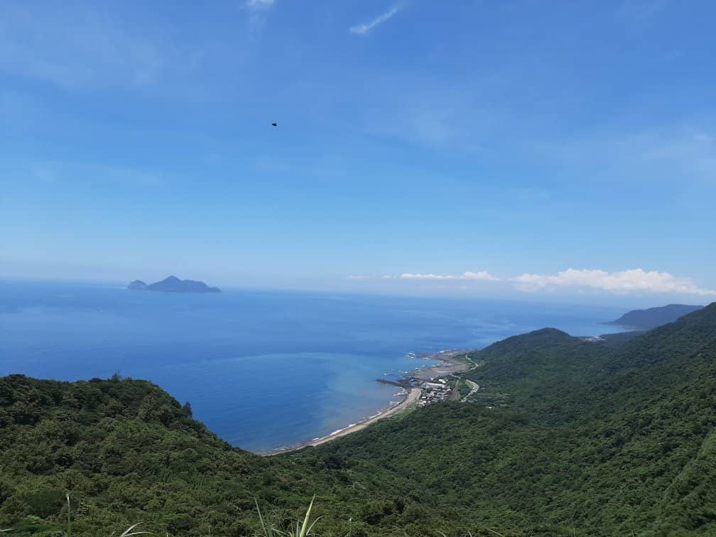
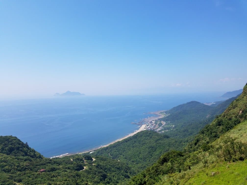
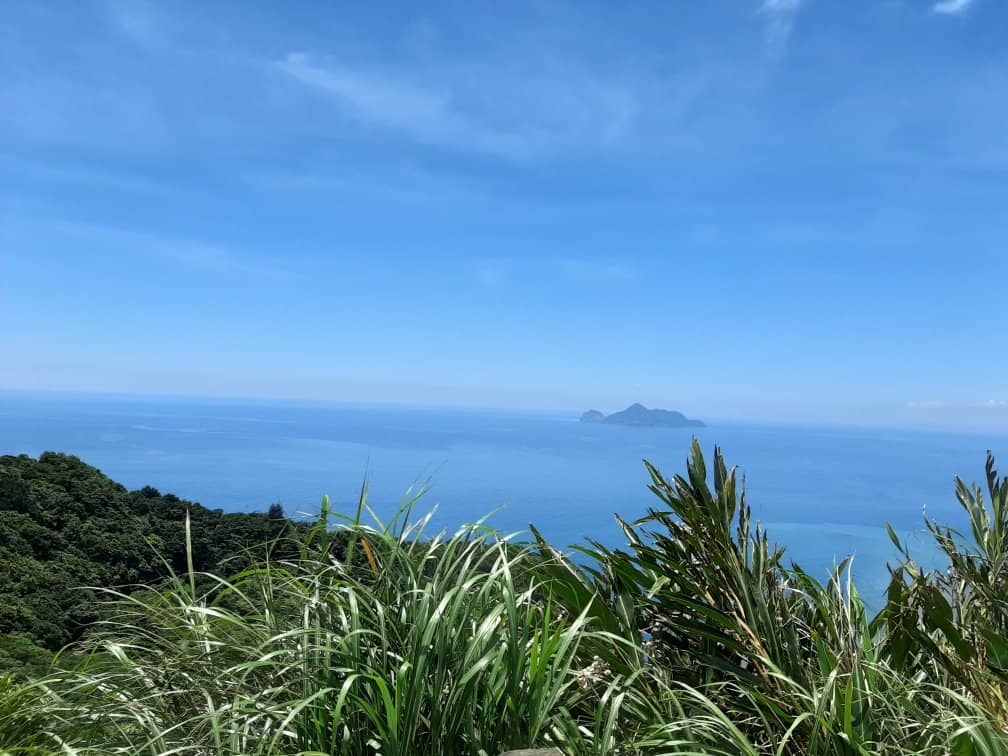
Coastal Vistas
Various viewpoints along the trail
Breathtaking panoramic views of the Pacific Ocean and Turtle Island, where mountains meet the sea.
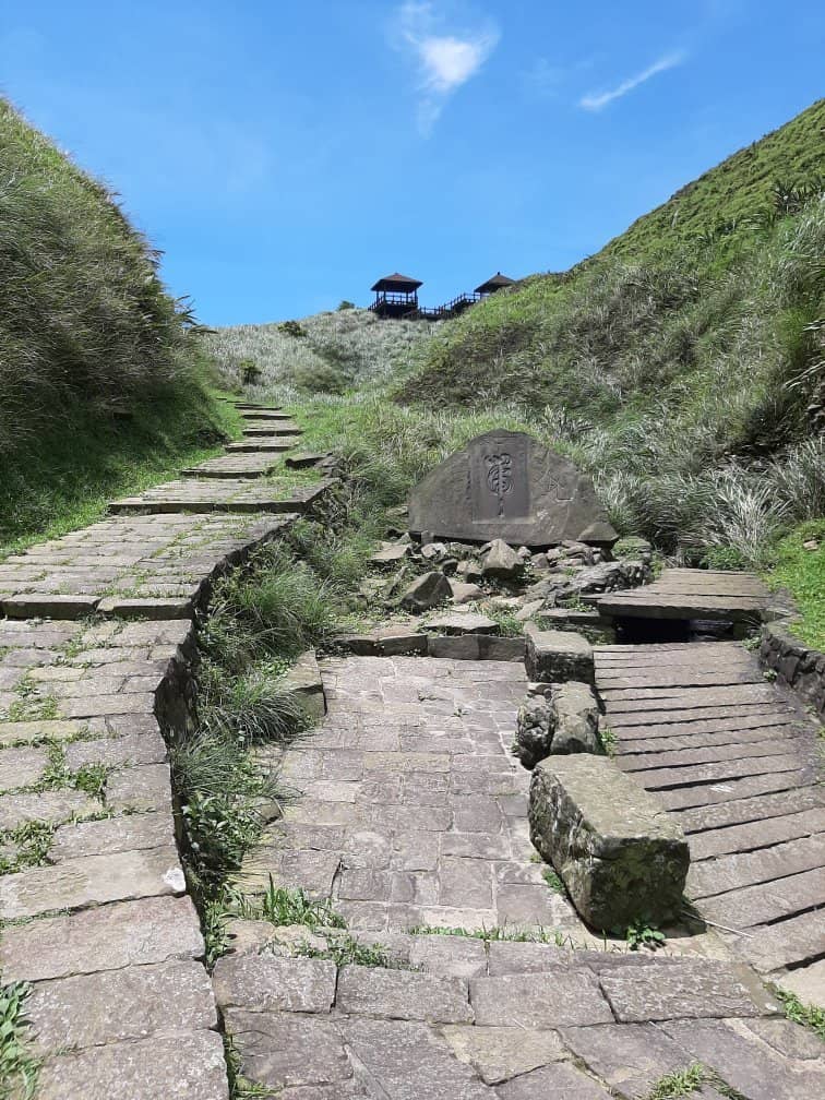
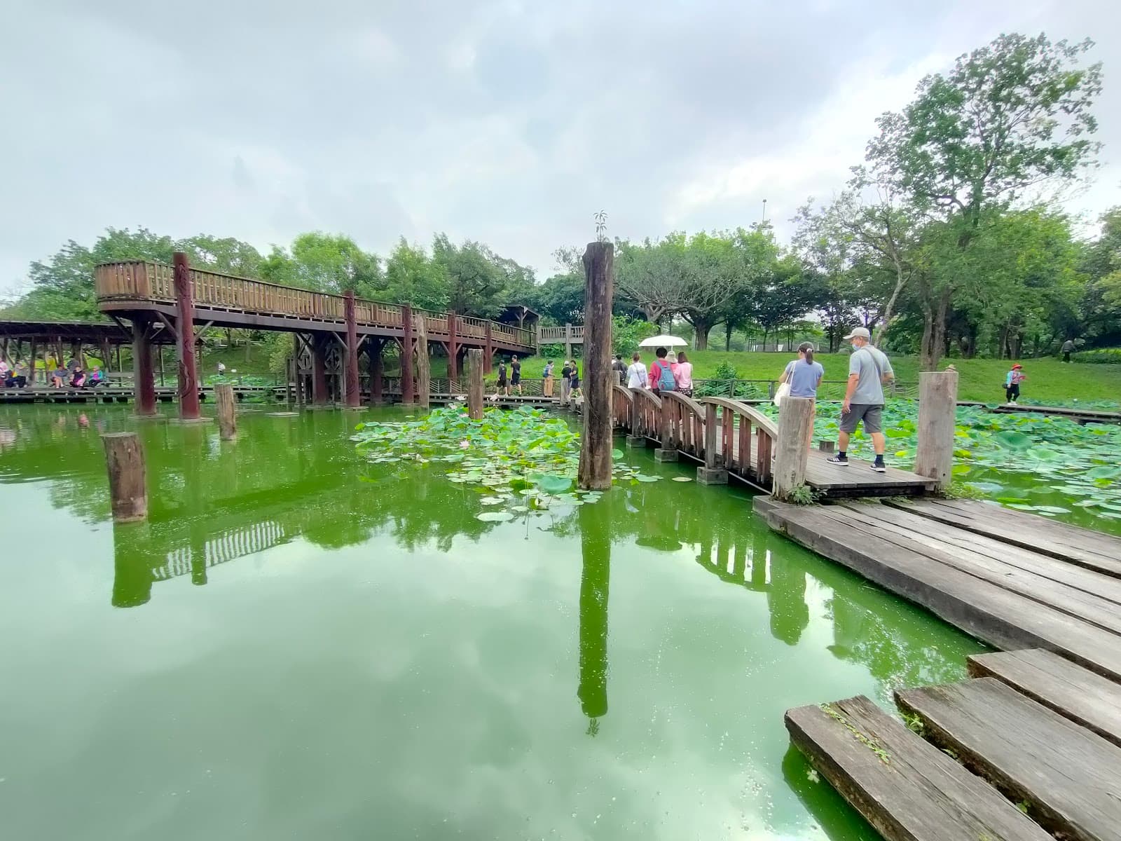
Historic Path
The entire trail
Trek along a preserved Qing Dynasty trail, offering a glimpse into Taiwan's historical connectivity.
Taoyuan Valley
Offshoot from the main trail
A serene valley rumored to have wild buffalo, offering a more secluded natural experience.
Plans like a pro.
Thinks like you
Planning Your Visit
Timing is Everything
Trail Logistics
Best Times
Insider Tips
from TikTok, Instagram & Reddit
👟 Wear Sturdy Shoes
Paths can be slippery, especially after rain. Good grip is essential for navigating steps and winding roads.
🎒 Pack Snacks & Water
Food options are scarce and vending machines may be closed. Bring plenty of provisions!
🗺️ Get a Trail Map
Visitor centers offer maps. Don't rely solely on GPS, especially if venturing off the main path.
⬆️ Choose the Steps!
Opt for the steps over winding roads for a faster and more direct route.
Tips
from all over the internet
👟 Wear Sturdy Shoes
Paths can be slippery, especially after rain. Good grip is essential for navigating steps and winding roads.
🎒 Pack Snacks & Water
Food options are scarce and vending machines may be closed. Bring plenty of provisions!
🗺️ Get a Trail Map
Visitor centers offer maps. Don't rely solely on GPS, especially if venturing off the main path.
⬆️ Choose the Steps!
Opt for the steps over winding roads for a faster and more direct route.
🌬️ Brace for Wind
Coastal winds can be strong, especially in the valley. Be prepared for gusts.
📸 Capture the Views
The scenery is stunning, especially where mountains meet the sea. Don't forget your camera!
🧥 Dress in Layers
Weather can change quickly. Bring layers for warmth, especially on cooler days.
What Travellers Say
Reviews Summary
Visitors praise the Caoling Historic Trail for its stunning coastal scenery and the unique beauty of its silvergrass fields, especially in autumn. The historical significance of the trail adds to its appeal. However, many note the importance of being well-prepared with food and water due to limited facilities, and caution that the hike can be more challenging than expected, particularly with unpredictable weather and strong winds.
"I did it during a Typhoon. The hike was incredible. I flew away from the wind but the views are stunning. The roads are very good maintained (if you could walk on them on a less windy day) - its going to be a little steep though. A full vlog about it is on my YouTube."
Tolga D.
"Nice trail. I would come back here again on a better weather day. When I went there, the trail was not very difficult, but it was long and windy. It's not very steep. So, if you go on a cool or cold day, don't forget to bring enough clothes.
You can see the view of the ocean contrasting with the green mountains. I love how majestic the mountains are!
We parked the car near the temple and climbed to the top of the mountain. It takes around 2 hours to go up, enjoy the view, and walk back."
Chen E.
"Suggest to:
1) Bring some food/ drinks as there are limited food options
2) Start from Dali and trek down to Fu Long. The hike took us 3 hours (excluding the trekking to Taoyuan Valley). We skipped that as we arrived only at 12+pm and the sun indeed got dark from 4+pm to 5pm onwards and wanted to ensure we can catch the train back to Taipei.
3) Before starting, do get a map from the visitor centre.
4) Along the way, there are winding roads or steps options. Take the steps! At first we didn’t know where the steps would lead us to due to the lack of signs, and took the winding roads. It was long and tiring and never ending! Until we finally bump into some hikers and asked for directions. It was more eye opening taking the steps (and faster too).
5) Overall an enjoyable hike despite slippery paths (due to the rain). When you hit the valley at the tiger tablet, mountain winds will definitely get pretty strong due to the landscape. Brace yourself haha.
6) if time allows, I suggest going earlier to checkout the Taoyuan valley as I heard there are buffalo’s and better view! Towards the end of the trail, you will be rewarded with some nice water streams and paddy fields
7) Do end off the trip with Fulong Rice takeaway 便當 - really yummy.
We had some light breakfast and were planning to have some lunch at Dali but the nearest restaurant was 20-30 mins away by foot. We bought some small mochi egg cake from the glasshouse at the start of the hike. Expecting that we can get some food from the management office along the way. Much to our dismay, it was close even though google says it’s opened!!!! We only managed to get some energy drink (30 TWD and only accept coins) from the vending machine there. Hence, the Fulong 便當 really tasted exceptionally good I guess.
Overall a good hike. But I personally don’t feel it’s as “easy” as what other fitter hikers say. Hence if you seldom work out, do prepare your legs for some muscle aches post hike."
Princess Lau
What People Like
What People Dislike
Frequently Asked Questions
🚇 🗺️ Getting There
The most common way is to take a train from Taipei to either Dali Station or Fulong Station. From Dali, you can start the hike towards Fulong. The journey takes about 1.5 hours. Some travelers also mention using services like Parkbus Taiwan for direct transport.
Yes, driving is an option, and some visitors park near temples. However, public transport via train is highly recommended and often more convenient for accessing the trailheads.
Most people recommend starting from Dali Station and hiking towards Fulong. This is because Fulong has a beach nearby, and you can enjoy a meal there after your hike.
Yes, you can catch a train from Fulong Station back to Taipei. It's advisable to check train schedules in advance, especially if you plan to finish your hike later in the day.
The train journey from Taipei to Dali or Fulong Station typically takes around 1.5 hours. Factor in time for getting to the station and walking to the trailhead.
🎫 🎫 Tickets & Entry
No, the Caoling Historic Trail is generally free to access. However, be aware that some facilities like vending machines might be closed or only accept coins.
The trail is open year-round, but it's best to check for any temporary closures due to weather conditions. It's advisable to start your hike with enough daylight.
No advance booking is required for the Caoling Historic Trail itself, as it's a public hiking path.
Yes, there are visitor centers or information points where you can obtain maps and information before starting your hike.
Information regarding pets on the trail is not widely available. It's best to check with local authorities or visitor centers for specific regulations. Generally, national parks and trails have restrictions on pets.
🎫 🚶 Onsite Experience
The main trail is approximately 10 km long, and it typically takes 3-4 hours to complete, depending on your pace and how much you stop for photos.
It's considered a moderate hike. While not extremely steep, it involves many steps and can be long and windy. Some find it more challenging than 'easy' descriptions suggest.
Wear comfortable hiking attire and sturdy shoes with good grip. Layers are recommended as the weather can change.
Restrooms are available, but some may be in poor condition or closed. It's best to use facilities at the start or end of your hike if possible.
Expect stunning coastal views, rolling hills covered in silvergrass (especially in autumn), and lush greenery. You might also encounter wild buffalo in Taoyuan Valley.
🍽️ 🍽️ Food & Dining
Food options are very limited along the trail itself. It's highly recommended to bring your own food and drinks.
Fulong offers more dining options, including the popular Fulong Rice takeaway. Dali has fewer options, with restaurants sometimes being a 20-30 minute walk away.
Vending machines are sometimes available, but they may be closed or only accept coins. It's best not to rely on them.
It's a local specialty in Fulong, often described as a delicious bento box. It's a great way to refuel after your hike.
While there aren't designated picnic areas, you can find spots to rest and enjoy your packed food, especially at rest pavilions.
📸 📸 Photography
Look for viewpoints overlooking the ocean and Turtle Island, the expansive silvergrass fields, and the historic stone paths.
Mornings and late afternoons offer beautiful light. Autumn is ideal for the silvergrass.
Drone usage may be restricted in national parks and protected areas. It's advisable to check local regulations before flying a drone.
A wide-angle lens is great for capturing the expansive landscapes. A telephoto lens can be useful for distant views of Turtle Island.
Keep an eye out for the contrast between the green mountains and blue sea, the textures of the silvergrass, and any wildlife like wild buffalo in Taoyuan Valley.


Social
from TikTok, Instagram & Reddit