Mountains-to-Sea Trail Folk Art Center to Craven Gap
A moderate 4-mile forest hike with stone steps, running alongside the Blue Ridge Parkway. Offers spring wildflowers and a peaceful escape.

Highlights
Must-see attractions

Social
From TikTok & Reddit
Best Time
Wildflowers bloom vibrantly
Mountains-to-Sea Trail Folk Art Center to Craven Gap
Best Time
Wildflowers bloom vibrantly
Highlights
Must-see attractions
A moderate 4-mile forest hike with stone steps, running alongside the Blue Ridge Parkway. Offers spring wildflowers and a peaceful escape.
"A pretty forest hike with lots of stone steps; ankle support is probably a good idea."

🗺️ Download Offline Maps
Trail can be unmarked at junctions. Use offline maps or GPS to avoid getting lost. :iphone:
👟 Ankle Support Recommended
Lots of stone steps on the trail. Consider shoes with good ankle support. :athletic_shoe:

Highlights
Discover the most iconic attractions and experiences
Forest Immersion
Mountains-to-Sea Trail
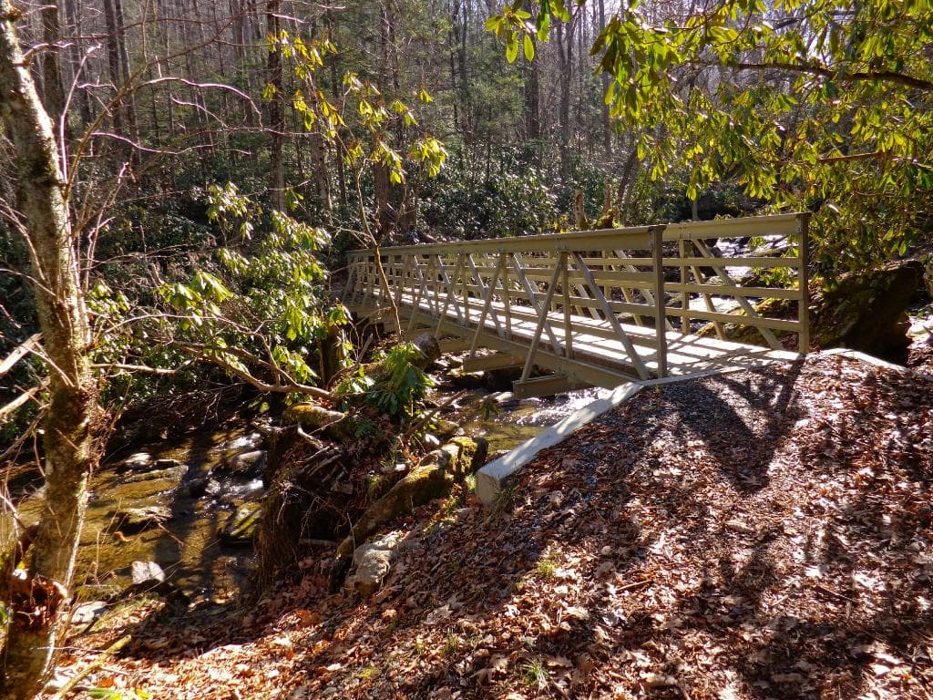
Experience a beautiful forest hike with lush greenery and a hard-packed trail, perfect for a moderate trek.

Blue Ridge Parkway Proximity
Near Blue Ridge Parkway
Hike alongside the scenic Blue Ridge Parkway, offering glimpses of distant mountains and valleys.

Spring Wildflowers
Mountains-to-Sea Trail
Discover a variety of wildflowers blooming along the trail during the spring season.
Plans like a pro.
Thinks like you
Planning Your Visit
Trail Navigation Challenges
Parking and Parkway Access
Best Times
Insider Tips
from TikTok, Instagram & Reddit
🗺️ Download Offline Maps
Trail can be unmarked at junctions. Use offline maps or GPS to avoid getting lost. :iphone:
👟 Ankle Support Recommended
Lots of stone steps on the trail. Consider shoes with good ankle support. :athletic_shoe:
🚗 Parking Location
Park on dirt road or grass off Town Mountain Rd before Blue Ridge Pkwy. :car:
💧 No Resting Spots
Be prepared for a continuous hike; there are no designated resting areas. :hiking_boot:
Tips
from all over the internet
🗺️ Download Offline Maps
Trail can be unmarked at junctions. Use offline maps or GPS to avoid getting lost. :iphone:
👟 Ankle Support Recommended
Lots of stone steps on the trail. Consider shoes with good ankle support. :athletic_shoe:
🚗 Parking Location
Park on dirt road or grass off Town Mountain Rd before Blue Ridge Pkwy. :car:
💧 No Resting Spots
Be prepared for a continuous hike; there are no designated resting areas. :hiking_boot:
🔊 Parkway Noise
Expect some traffic noise from the Blue Ridge Parkway. :speaker:
What Travellers Say
Reviews Summary
This section of the Mountains-to-Sea Trail offers a pleasant, moderate hike through a beautiful forest with the unique challenge of unmarked junctions. While it lacks sweeping vistas, it provides a peaceful escape with opportunities to enjoy spring wildflowers and proximity to the Blue Ridge Parkway. Be prepared for stone steps and potential navigation difficulties.
"While I love this area, it is NOT currently hikeable. Nor can it be reach from the Blue Ridge Parkway by car. However, they have clear enough parking spots for a half dozen vehicles, if you'd like to walk the Parkway."
PapaJoe Gaudet
"Very pretty forest hike—with lots of stone steps. Ankle support is probably a good idea. My watch clocked it at 4 miles exactly. 2 miles in you hit the Blue Ridge Parkway and I could have continued on, but turned back. My clock also said 705 elevation there and back. Unsure of accuracy, but it felt uphill both ways (I’m out of practice hiking, though). It did have one clearing that you could see some mountains, but it’s brief. Also note there are not any resting places."
Blair Collins
"Do you remember those choose your own adventure books from the '80s? this trail is like one of those. there's lots of crossroads where you have to make a decision, because the trail isn't marked.
I was trying to hike alongside the parkway to Haw Creek valley overlook. seems like it should have been pretty easy, right? But before I knew it I was spit out onto a residential road (independence boulevard) with nowhere to go but back where I came from.
I'm sure it's a great trail if you know where to turn, I'll come back and give it another try and choose a different adventure."
Marshall Jones
What People Like
What People Dislike
Frequently Asked Questions
🚇 🗺️ Getting There
The most common access point is via Town Mountain Road, where you can find parking on the dirt road or grass before reaching the Blue Ridge Parkway. Direct access from the Parkway itself can be tricky.
Yes, there is parking available off Town Mountain Road. It's recommended to park before you reach the Blue Ridge Parkway entrance.
While the trail runs alongside the Parkway, direct car access to specific trailheads can be limited. You can walk along the Parkway to access trail sections.
Hikers suggest using offline maps or a GPS device as the trail can be unmarked at various crossroads, leading to potential confusion.
Public transport options are generally limited for accessing trailheads in this mountainous region. Driving is the most common method.
🎫 🎫 Tickets & Entry
No, hiking the Mountains-to-Sea Trail is free and does not require any tickets or passes for entry.
There are no entrance fees for this specific section of the Mountains-to-Sea Trail.
The trail is open year-round from dawn to dusk. There are no set operating hours.
While official guided tours might be rare for this specific section, local hiking groups or guides may offer excursions. It's best to check local Asheville tourism resources.
It is generally advised to hike during daylight hours for safety and navigation purposes, though the trail itself is not officially closed at night.
🎫 🥾 Onsite Experience
This section is considered a moderate hike, featuring some elevation gain and numerous stone steps. It's about 4 miles round trip.
There are brief clearings with distant mountain views, but not sweeping vistas. The Haw Creek valley overlook offers some distant views.
Expect a hard-packed trail with many stone steps. Ankle support is recommended.
Dogs are generally allowed on the Mountains-to-Sea Trail, but they must be kept on a leash. Always check local regulations.
There are no restrooms or facilities directly on this section of the trail. Plan accordingly.
📸 📸 Photography
Look for clearings with mountain views and the vibrant wildflowers in spring. The forest itself offers beautiful, dappled light for photography.
Yes, this trail can offer beautiful fall colors, especially in the surrounding forests.
Early morning or late afternoon often provide the best light for landscape and forest photography, with softer shadows.
Drone usage may be restricted in national forests and near the Blue Ridge Parkway. Always check regulations before flying.
The stone steps and the way the trail winds through the forest can create interesting photographic compositions.
For Different Travelers
Tailored advice for your travel style
👨👩👧 Families with Kids
Due to the potential for unmarked junctions, it's crucial for families to stay together and have a reliable navigation method (like offline maps) to prevent anyone from getting separated or lost.
🚶♀️ Solo Hikers
While there are no designated resting spots, the trail's hard-packed surface is generally easy to walk on.
📸 Photography Enthusiasts
For the best light, consider visiting during the golden hours of early morning or late afternoon.
Deep Dives
In-depth insights and expert knowledge
Navigating the Unmarked Trail
Consider this section a 'choose your own adventure' experience, as one Reddit user described it.
Trail Conditions and Features
While the trail runs parallel to the Blue Ridge Parkway, direct, sweeping vistas are not abundant. You'll find brief clearings offering glimpses of distant mountains and valleys, with the Haw Creek valley overlook providing a more defined, albeit distant, view.
Seasonal Beauty and Wildlife
In the fall, the surrounding foliage can offer attractive colors, though it's not as renowned for dramatic fall foliage as some other areas.
Social
from TikTok, Instagram & Reddit