
Sky Country Trailhead
Explore scenic trails in Cougar Mountain Park, known for its gravel paths and natural beauty, perfect for hikes and dog walks.
Highlights
Must-see attractions

Social
From TikTok & Reddit
Best Time
Enjoy nature's tranquility
Sky Country Trailhead
Best Time
Enjoy nature's tranquility
Highlights
Must-see attractions
Explore scenic trails in Cougar Mountain Park, known for its gravel paths and natural beauty, perfect for hikes and dog walks.
"Beautiful trail, though could use better marking. Download offline maps!"

🗺️ Download Offline Maps
Cell service is unreliable. Get offline maps for navigation, especially if seeking specific landmarks.
💧 Bathroom Break Strategy
Restrooms are only at the main entrance. Plan your stops carefully to avoid long waits.

Highlights
Discover the most iconic attractions and experiences
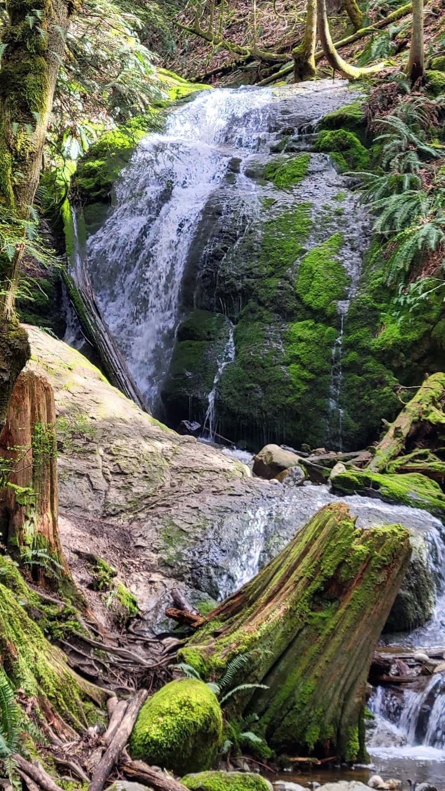
Coal Creek Falls
Cougar Mountain Regional Wildland Park
A beautiful, though sometimes elusive, waterfall. The hike can be longer than expected, so be prepared.
Sky Country Trail
Cougar Mountain Regional Wildland Park
A wide, gravel path perfect for a long, scenic walk through forests and open areas.

The Cute Little Dam
Near Coal Creek Falls trail
A charming, small dam that some visitors mistake for a waterfall. A nice surprise on the trail.
Plans like a pro.
Thinks like you
Planning Your Visit
Navigation is Key
Trail Conditions & Facilities
Best Times
Insider Tips
from TikTok, Instagram & Reddit
Taking a date to Cougar Mountain in Bellevue this week, and I can't find any maps of the trails! Does anyone know a simple route to the best scenic parts?
🗺️ Download Offline Maps
Cell service is unreliable. Get offline maps for navigation, especially if seeking specific landmarks.
💧 Bathroom Break Strategy
Restrooms are only at the main entrance. Plan your stops carefully to avoid long waits.
Best running trails around Bellevue?
Hiking Recommendations this Weekend within 2-3 hours of Seattle?
👟 Wear Comfortable Shoes
The Sky Country Trail is gravel, so sturdy footwear is recommended for a comfortable hike. [:athletic_shoe:]
🐶 Dog-Friendly Trails
Leashed dogs are welcome on the trails, making it a great spot for furry companions. [:dog:]
Tips
from all over the internet
🗺️ Download Offline Maps
Cell service is unreliable. Get offline maps for navigation, especially if seeking specific landmarks.
💧 Bathroom Break Strategy
Restrooms are only at the main entrance. Plan your stops carefully to avoid long waits.
👟 Wear Comfortable Shoes
The Sky Country Trail is gravel, so sturdy footwear is recommended for a comfortable hike. [:athletic_shoe:]
🐶 Dog-Friendly Trails
Leashed dogs are welcome on the trails, making it a great spot for furry companions. [:dog:]
📸 Capture the Scenery
Beautiful natural views abound. Bring your camera to capture the forested landscapes. [:camerawithflash:]
What Travellers Say
Reviews Summary
Visitors praise the beautiful natural scenery and well-maintained trails at Sky Country Trailhead, making it a lovely spot for hikes and dog walks. However, many note that trail navigation can be confusing, and cell reception is poor, necessitating offline maps. The limited restroom facilities are also a point of consideration for longer visits.
"I love how well-maintained these trails are however I am giving it a four instead of a five because you have to download Google off-line maps as there is little to no reception throughout the park. There are marker posts that let you know the trail name and the distance of the trail, but there is no map. There is only a bathroom at the main entrance, so be prepared to hold it if you take a wrong turn on accident still very beautiful and everybody seems to be respectful and friendly."
Nicole Adams
"Big part of the Cougar mountain reserve and park. The sky county trail is gravel and wide but goes for a long walk and can adjoin other trails. We took this looking for the Coal Creek Falls as many others also but found it was a long long hike to the falls and no one could navigate with their phone. So confused we walked a little then came back to car. Parking was ample but the park was blocked by gates etc so that’s as far as one can drive. We failed to find the falls but nice forested and dry grasses were the scenery."
Ann Mari Gantenbein
"Fun little trail, though confusing! We couldn't find the waterfall unless it was the very tiny one from the dam? Not sure... but we did a full loop from where we started in the parking lot, that looped us back, which was about 2.5 miles. Kid friendly and dog friendly. Lots to see. Beautiful views of nature. Big parking lot."
Danielle
What People Like
What People Dislike
Frequently Asked Questions
🚇 🗺️ Getting There
Sky Country Trailhead is part of the Cougar Mountain Regional Wildland Park. Access is typically via car, with ample parking available at the main entrance. Gates may block further driving access into certain areas.
Information on public transportation options is limited. It's best to check local transit schedules for routes serving the Cougar Mountain area, though driving is generally the most convenient method.
The park offers ample parking at the main entrance, which is convenient for accessing the trailhead and nearby facilities.
No, you cannot drive directly to Coal Creek Falls. It requires a hike from the trailhead, and the trail can be long and confusing to navigate without proper maps.
The Sky Country Trail is described as wide and gravel, suggesting it could be suitable for cycling. However, it's always best to check park regulations for specific trail access for bikes.
🎫 🎫 Tickets & Entry
There is typically no entrance fee for Cougar Mountain Regional Wildland Park, including the Sky Country Trailhead. It's a public park managed for recreational use.
As a regional park, Cougar Mountain is generally open from dawn to dusk. Specific hours can vary, so it's advisable to check the official park website for the most current information.
No advance booking or tickets are required for general access to Sky Country Trailhead or Cougar Mountain Regional Wildland Park. It's a public access area.
For general day hiking, no special permits are usually required. However, if you plan on organizing large group events or specific activities, it's wise to check with park management.
Generally, parks are closed after dark for safety reasons. It's recommended to complete your hike before dusk and be aware of park closing times.
🎫 🧭 Onsite Experience
While there are marker posts indicating trail names and distances, some visitors find the trail markings confusing and could use better signage, especially when trying to find specific destinations like Coal Creek Falls.
The Sky Country Trail itself is described as gravel and wide, making it suitable for long walks. Other adjoining trails may vary in terrain.
Yes, the trails are generally considered kid-friendly, with some loops being around 2.5 miles. The natural scenery offers plenty to see for younger visitors.
Restrooms are only available at the main entrance of the park. There are no facilities along the trails themselves, so be prepared.
Visitors can expect beautiful views of nature, including forested areas and dry grasses. It offers a peaceful escape into the natural landscape.
📸 📸 Photography
The forested areas and scenic natural landscapes offer great opportunities for photography. The 'cute little dam' also provides a unique photo subject.
Morning hikes are recommended for pleasant lighting. Partly cloudy days can also offer diffused light, but direct sun can be strong in open areas.
Drone usage regulations can vary by park. It's essential to check the official Cougar Mountain Regional Wildland Park guidelines regarding drone operation before flying.
While not guaranteed, the park's natural setting may offer opportunities to photograph local birds and small mammals. Always maintain a safe distance and respect wildlife.
Besides the general natural beauty, the Coal Creek Falls and the small dam are often mentioned as points of interest for photos.
For Different Travelers
Tailored advice for your travel style
👨👩👧 Families with Kids
Remember that restrooms are only at the main entrance, so plan bathroom breaks accordingly.
🚶♀️ Solo Hikers & Dog Walkers
As with all visitors, the key is preparation: download offline maps due to poor cell service and be aware of the limited restroom facilities.
Deep Dives
In-depth insights and expert knowledge
Navigating the Trails: Tips from the Community
Several hikers have shared experiences of being unable to navigate their phones to find the falls, highlighting the need for a physical map or a pre-downloaded digital one.
The Elusive Coal Creek Falls
Despite the navigational challenges, the journey to the falls is often described as beautiful, with scenic forested surroundings.


Social
from TikTok, Instagram & Reddit