
Castle Peak
A challenging 9,103 ft peak near Donner Summit offering breathtaking 360° Sierra Nevada views after a steep, rocky ascent.

Highlights
Must-see attractions

Social
From TikTok & Reddit
Best Time
Clear skies & cooler temps
Castle Peak
Best Time
Clear skies & cooler temps
Highlights
Must-see attractions
A challenging 9,103 ft peak near Donner Summit offering breathtaking 360° Sierra Nevada views after a steep, rocky ascent.
"The 360 degree views from the summit on a clear day are well worth the challenge and elevation gain."

👟 Sturdy Footwear is Key
The last mile is steep & rocky. Good grip is essential to avoid slips!
💧 Hydrate & Fuel Up
Bring plenty of water and snacks; the climb is demanding and there are no services on the trail.

Quick Facts
Rating
4.8 · 31 reviews
Type
Natural Feature
Address
Highlights
Discover the most iconic attractions and experiences
Summit Views
Castle Peak Summit
Breathtaking 360-degree panoramas of the Sierra Ridge, Tahoe Basin, and distant peaks like Shasta and Lassen.
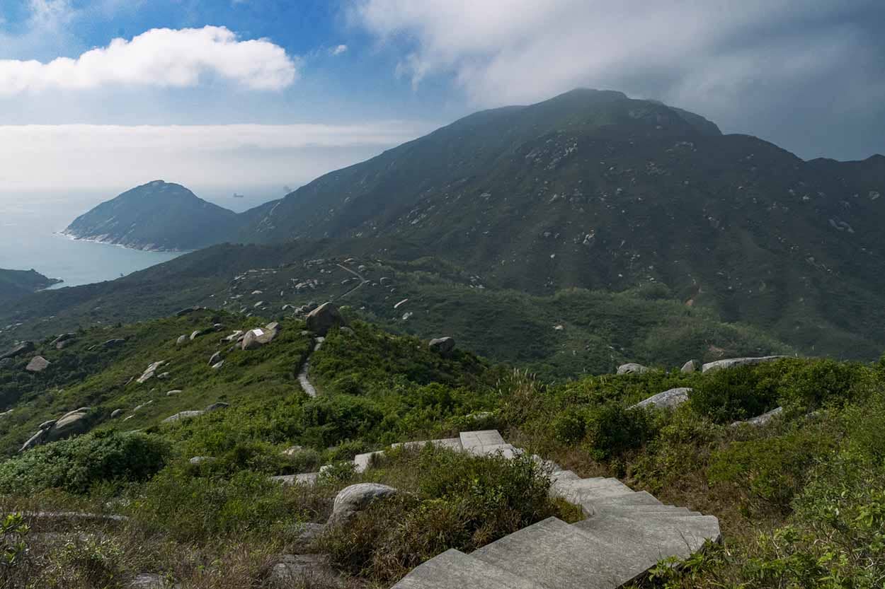
PCT Junction
Trail junction with Pacific Crest Trail
A scenic spot where the trail meets the iconic Pacific Crest Trail, offering a sense of accomplishment.

Rock Scrambling
Final approach to the summit
A thrilling, albeit tricky, section of rock scrambling that adds an adventurous element to the hike.
Plans like a pro.
Thinks like you
Planning Your Visit
Timing Your Ascent
Trail Conditions & Gear
Best Times
Insider Tips
from TikTok, Instagram & Reddit
👟 Sturdy Footwear is Key
The last mile is steep & rocky. Good grip is essential to avoid slips!
💧 Hydrate & Fuel Up
Bring plenty of water and snacks; the climb is demanding and there are no services on the trail.
🚗 Arrive Early for Parking
Parking fills up fast, especially on weekends. Aim for an early start to secure a spot.
🗺️ Trail Navigation
Follow the single track to the right after the fire road ends. Watch for the PCT junction.
Tips
from all over the internet
👟 Sturdy Footwear is Key
The last mile is steep & rocky. Good grip is essential to avoid slips!
💧 Hydrate & Fuel Up
Bring plenty of water and snacks; the climb is demanding and there are no services on the trail.
🚗 Arrive Early for Parking
Parking fills up fast, especially on weekends. Aim for an early start to secure a spot.
🗺️ Trail Navigation
Follow the single track to the right after the fire road ends. Watch for the PCT junction.
📸 Capture the Views
The summit offers incredible 360° vistas – don't forget your camera!
What Travellers Say
Reviews Summary
Castle Peak is lauded for its spectacular 360-degree summit views, making the challenging hike worthwhile. While the initial trail is moderate, the final mile is steep and involves rock scrambling, requiring good fitness. Parking can be an issue on busy days, and some find the trail navigation tricky.
"Got to the trailhead around 1pm on a Monday in August. Plenty of parking there, and easy to get to from the freeway. Tough hike. Ended with a tricky bit of rock scrambling. First 1.5 miles were soft trail wide enough to drive an SUV on, and then it changed completely - relentless uphill. Great 360 views from the summit. Definitely could see Shasta, Lassen, as well as the Tahoe ski slopes. Total round trip was around 6 miles with 1900 ft elevation gain, and took 2.5 hours."
Vipul Singh
"Castle Peak is a great mountain to hike up near Donner Pass. It is about a 2.5 mile hike up from the trailhead, 5+mile round trip. The first 1.5 miles is a slight incline on a dirt fire road, the last mile is steeper and more challenging with switchbacks and loose rock. The 360 degree views from the summit on a clear day are well worth the challenge and elevation gain."
Brendan Kiely
"Short, direct hike, straight up Castle Peak, giving great views of the Sierra Ridge and Tahoe Basin.
You can either drive to the end of the fire trail or park at the end of the sealed road on the opposite side of the freeway from Boreal. The hike on the fire trail is slightly rising up to the end where a single track trail breaks off to the right. Follow up hill until you get to the junction with the PCT then take the trail that heads straight up to the summit of Castle Peak. It is a steep trail in sections but not technical.
On a clear day you can see the snow capped Lassen Peak in the north."
Devin Ramdutt
What People Like
What People Dislike
Frequently Asked Questions
🚇 🗺️ Getting There
Castle Peak is accessible from I-80 near Donner Summit. You can park at the end of the sealed road on the opposite side of the freeway from Boreal, or drive to the end of the fire trail if conditions allow.
While the initial fire road is clear, finding the single-track trail to the summit can be tricky for some. Look for it branching off to the right after the first 1.5 miles.
No, Castle Peak is a hiking destination. While you can drive part of the way on a fire trail, the final ascent requires hiking and some scrambling.
Take I-80 West towards Donner Summit. Look for exits near Boreal Mountain Resort. The trailhead is typically accessed from a turnoff near the freeway.
Winter access can be challenging due to snow. Avalanche gear and expertise are recommended for winter ascents, and conditions can change rapidly.
🎫 🎫 Tickets & Entry
Generally, no permit is required for day hiking Castle Peak. However, always check with the Tahoe National Forest for any current regulations or special permits needed for overnight stays or specific activities.
Castle Peak is an outdoor natural area and is accessible year-round during daylight hours. There are no official operating hours, but access may be limited by snow in winter.
There is no entrance fee to hike Castle Peak itself. However, if you plan to use nearby facilities or parking areas that require a fee (like some ski resort lots), those may apply.
As there are no tickets required for hiking, you don't need to purchase anything in advance. Just plan your visit based on weather and crowd conditions.
Since there's no admission fee, there are no discounts available. The 'cost' is your effort and time to enjoy the hike and views.
🎫 ⛰️ Onsite Experience
The round trip hike is about 5-6 miles with 1900 ft of elevation gain. It typically takes 2.5 to 4 hours, depending on your pace and how long you spend at the summit.
The first 1.5 miles are a moderate incline on a fire road. The last mile is steeper and more challenging with switchbacks and loose rock, including some scrambling. It's considered moderate to strenuous.
Expect stunning 360-degree views of the Sierra Nevada range, including Lake Tahoe, Donner Pass, and on clear days, distant peaks like Mount Shasta and Lassen Peak.
While the initial part is manageable, the final mile is demanding. Beginners in good shape might enjoy it, but it's a challenging hike with significant elevation gain and scrambling.
Restroom facilities are typically limited at trailheads in this area. It's best to use facilities before you leave town or at a nearby rest stop.
📸 📸 Photography
Golden hour, shortly after sunrise or before sunset, offers the most dramatic lighting for landscape photography. Midday can be harsh but still provides excellent visibility for panoramic shots.
A wide-angle lens is great for capturing the expansive vistas. A telephoto lens can be useful for isolating distant peaks. Consider a tripod for stable shots, especially in lower light.
The summit itself offers the most iconic 360-degree views. The junction with the PCT also provides scenic opportunities. Look for interesting rock formations along the trail.
Drone usage is often restricted in national forests and wilderness areas. Always check current regulations with the Tahoe National Forest before flying a drone.
Beyond the summit, look for wildflowers in season, interesting rock formations, and the changing perspectives of the surrounding mountains as you ascend.


Social
from TikTok, Instagram & Reddit