
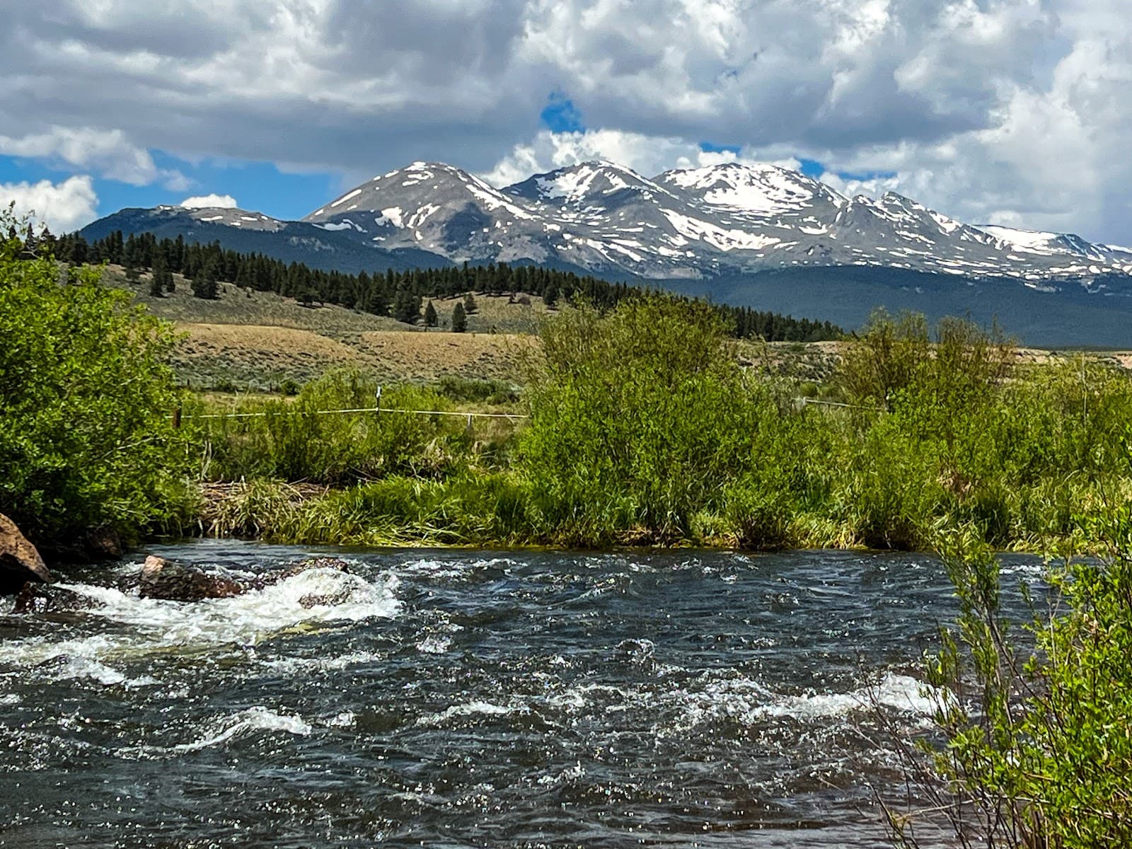
Top of the Rockies Scenic Byway
A breathtaking Colorado drive over 12,000 ft, featuring the Continental Divide and stunning alpine scenery. Seasonal access.

Highlights
Must-see attractions

Social
From TikTok & Reddit
Best Time
Roads open, best fall colors
Top of the Rockies Scenic Byway
Best Time
Roads open, best fall colors
Highlights
Must-see attractions
A breathtaking Colorado drive over 12,000 ft, featuring the Continental Divide and stunning alpine scenery. Seasonal access.
"Wow! Gorgeous scenery. You will need a jacket and hat at Independence Pass. "

🚗 Check Road Status First
Independence Pass is seasonal! Always verify road conditions before you go. ⚠️
🧥 Pack Layers for Altitude
It's cold at 12,000+ ft! Bring a jacket & hat, even in summer. ☁️

Quick Facts
Highlights
Discover the most iconic attractions and experiences
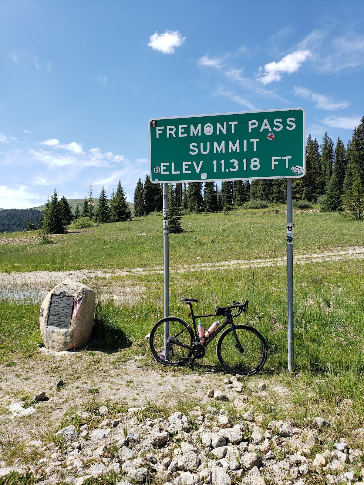
Independence Pass Summit
Near Aspen
The highest paved state highway in the USA, offering breathtaking panoramic views and a true 'top of the world' feeling.

Continental Divide Crossing
Independence Pass
Stand astride the North American Continental Divide, a significant geographical landmark with historical and natural importance.

Leadville Historic Town
Leadville
Explore a charming Wild West town with rich mining history, offering a unique cultural experience along the byway.

Fall Foliage Spectacle
Throughout the byway
Witness a stunning transformation as aspen groves turn golden, creating a magical, vibrant landscape in autumn.
Plans like a pro.
Thinks like you
Planning Your Visit
Seasonal Road Closures
Altitude and Weather
Best Times
Insider Tips
from TikTok, Instagram & Reddit
🚗 Check Road Status First
Independence Pass is seasonal! Always verify road conditions before you go. ⚠️
🧥 Pack Layers for Altitude
It's cold at 12,000+ ft! Bring a jacket & hat, even in summer. ☁️
⛽ Fuel Up Beforehand
Limited services. Gas stations and food options are scarce, especially in Aspen. :fuelpump:
📸 Pull Over Safely
Many scenic pull-offs. Use them for photos and to let faster traffic pass. 📷
Tips
from all over the internet
🚗 Check Road Status First
Independence Pass is seasonal! Always verify road conditions before you go. ⚠️
🧥 Pack Layers for Altitude
It's cold at 12,000+ ft! Bring a jacket & hat, even in summer. ☁️
⛽ Fuel Up Beforehand
Limited services. Gas stations and food options are scarce, especially in Aspen. :fuelpump:
📸 Pull Over Safely
Many scenic pull-offs. Use them for photos and to let faster traffic pass. 📷
💧 Stay Hydrated
Altitude can cause dehydration. Drink plenty of water throughout your drive. :droplet:
What Travellers Say
Reviews Summary
Visitors consistently praise the Top of the Rockies Scenic Byway for its absolutely breathtaking scenery and the exhilarating drive, especially over Independence Pass. Many highlight the stunning mountain vistas and the unique experience of crossing the Continental Divide. However, some note the seasonal road closures, the potential for cold weather even in summer, and the limited services and high prices in nearby Aspen.
"Wow! Gorgeous scenery. It is 1st week of July and it is cold and there is snow. You will need a jacket and hat at Independence Pass. I am not a fan of heights but going up the mountain was worse than going down. We encountered jaywalking sheep that posed for us. We went from Leadville to Aspen to get to Ashcroft ghost town then back. Gorgeous drive mountains had snow. There are pull offs for the creek and picnic areas. I would suggest to get your food prior to going. Aspen has zero fast food and the food prices are for the rich. We found Clark's supermarket that had a deli, hot food, and packaged sandwiches. Priced around $7-$10. Excellent place that was suggested by a local on where they shop. The mountain road is narrow with only one car at a time so be prepared to stop and wait with the signal."
Ud Luze
"Beautiful drive. Would be more spectacular on a clear day. We had smoke in the skies the day we went"
Vernon DeLung
"Must visit byway, once in a lifetime !!!"
Jithendra Krishnakumar
What People Like
What People Dislike
Frequently Asked Questions
🚇 🗺️ Getting There
The byway can be accessed from several points, including near Leadville, Twin Lakes, Aspen, Minturn, and Red Cliff. Independence Pass connects Aspen to Twin Lakes and is a major highlight. +1
It's not a single loop, but rather a network of roads. Independence Pass is a seasonal segment connecting Aspen and Twin Lakes, often driven as an out-and-back or part of a larger road trip.
Many travelers enjoy driving from Leadville south to Twin Lakes for stunning mountain views. Others love the Independence Pass section for its dramatic elevation changes and vistas. +1
No, the Independence Pass section is typically closed to all vehicle traffic from late October/early November through late May/early June due to heavy snow.
While AWD/4WD is recommended for mountain driving, especially in shoulder seasons, the paved sections are generally manageable with a standard vehicle when open and clear. However, always check conditions.
🎫 🎫 Tickets & Entry
No, the Top of the Rockies Scenic Byway is a public road and does not require tickets or an entrance fee.
The byway itself is free to drive. However, any activities like visiting national parks or specific attractions along the route may have their own fees.
The byway is generally accessible year-round, but the Independence Pass section is seasonally closed due to snow. Always check current road status.
Yes, there are numerous pull-offs and trailheads along the byway that allow for hiking and exploring the surrounding nature.
Independence Pass is part of the scenic byway and does not have a separate admission fee. It is free to drive when open.
🎫 🏞️ Onsite Experience
The summit of Independence Pass offers unparalleled 360-degree views. Other notable spots include pull-offs near Twin Lakes and overlooks showcasing snow-capped peaks.
Absolutely! Numerous trails range from short nature walks to more strenuous hikes, offering opportunities to immerse yourself in the Rocky Mountain landscape.
Keep an eye out for elk, deer, bighorn sheep, and various bird species. You might even encounter sheep crossing the road!
The main paved sections are generally suitable, but the Independence Pass segment is narrow and winding with hairpin turns, which can be challenging for very large RVs. Drive cautiously.
The highest point is Independence Pass, reaching an elevation of 12,095 feet (3,687 meters) above sea level.
🍽️ 🍽️ Food & Dining
Dining options are limited directly on the byway. Towns like Leadville offer more choices. Aspen has restaurants but they can be very expensive; consider grocery stores for picnic supplies.
Yes, there are designated picnic areas and scenic pull-offs where you can enjoy a meal with a view. Packing your own food is highly recommended.
Aspen is known for its high-end dining. Expect very expensive food prices. Grocery stores like Clark's Market offer more affordable deli options.
Fast food options are scarce. Leadville has some casual eateries, but Aspen has very few, if any, traditional fast-food chains.
It's best to pack a cooler with sandwiches, snacks, and drinks. This saves time and money, and allows you to enjoy meals at scenic spots.
📸 📸 Photography
The summit of Independence Pass, panoramic mountain vistas, fall foliage (if timed right), historic towns like Leadville, and the Continental Divide are prime photo spots. +1
Early morning or late afternoon often provide the best light for landscape photography, with softer shadows and warmer tones.
A standard camera or smartphone is sufficient. However, a wide-angle lens can be useful for capturing the expansive mountain scenery.
Generally, no. However, always be mindful of safety, stay on designated paths, and respect any private property or wildlife.
Fall offers vibrant colors, while summer provides lush green landscapes and clear blue skies. Winter offers dramatic snowscapes but limited access. +1


Social
from TikTok, Instagram & Reddit