
Mount Rose Highway Nevada
A breathtaking scenic byway connecting Reno to Lake Tahoe, offering stunning Sierra Nevada vistas and access to winter sports.
Highlights
Must-see attractions

Social
From TikTok & Reddit
Best Time
Clear skies, fewer crowds
Mount Rose Highway Nevada
Best Time
Clear skies, fewer crowds
Highlights
Must-see attractions
A breathtaking scenic byway connecting Reno to Lake Tahoe, offering stunning Sierra Nevada vistas and access to winter sports.

🚗 Check Road Conditions
Always check NV DOT for closures due to snow or fire before driving. ⚠️
🌄 Pull Over Safely
Use designated pull-offs for photos; avoid stopping on the main road. :camerawithflash:
Quick Facts
Address
Highlights
Discover the most iconic attractions and experiences
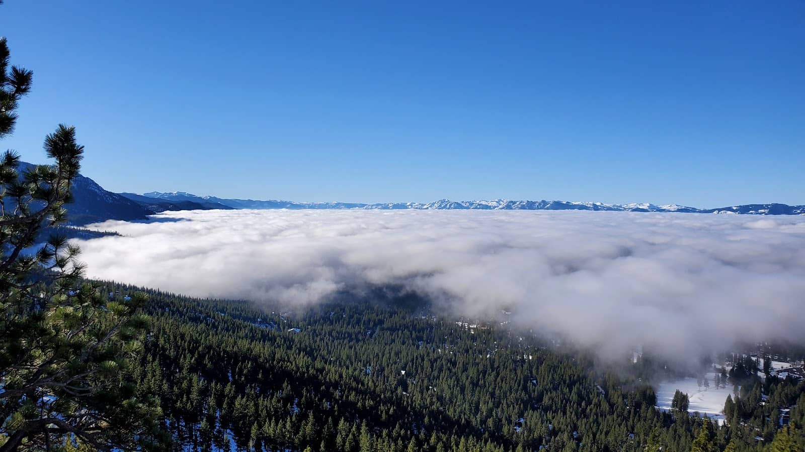
Panoramic Sierra Views
Various pull-offs along the highway
Breathtaking vistas of the Sierra Nevada mountains and Lake Tahoe basin. Perfect for a scenic drive and photo ops.
Gateway to Lake Tahoe
Connects Reno to Incline Village
The most direct route from Reno to the north shore of Lake Tahoe, offering access to skiing, hiking, and lakeside activities.

Backcountry Ski Access
Near Mount Rose Ski Tahoe
A popular corridor for accessing backcountry skiing and snowboarding in the winter months.
Sunset Spectacles
Wide pull-outs on the highway
Catch stunning sunset views from easily accessible roadside spots.
Plans like a pro.
Thinks like you
Planning Your Visit
Seasonal Road Conditions
Navigating Traffic & Safety
Best Times
Insider Tips
from TikTok, Instagram & Reddit
🚗 Check Road Conditions
Always check NV DOT for closures due to snow or fire before driving. +1 ⚠️
🌄 Pull Over Safely
Use designated pull-offs for photos; avoid stopping on the main road. :camerawithflash:
🚴 Share the Road Cautiously
Cyclists and drivers must be aware of each other; shoulders can be narrow. :athletic_shoe:
⚠️ Be Prepared for Weather
Conditions change rapidly. Carry layers, water, and emergency supplies. ☂️
Tips
from all over the internet
🚗 Check Road Conditions
Always check NV DOT for closures due to snow or fire before driving. +1 ⚠️
🌄 Pull Over Safely
Use designated pull-offs for photos; avoid stopping on the main road. :camerawithflash:
🚴 Share the Road Cautiously
Cyclists and drivers must be aware of each other; shoulders can be narrow. :athletic_shoe:
⚠️ Be Prepared for Weather
Conditions change rapidly. Carry layers, water, and emergency supplies. ☂️
🌲 Respect Nature
Stay on marked trails and pack out all trash to preserve the environment. :evergreen_tree:
What Travellers Say
Reviews Summary
Travelers praise Mount Rose Highway for its stunning scenic beauty and its role as a vital link between Reno and Lake Tahoe. The panoramic views from its numerous pull-offs are a major highlight, especially during sunrise and sunset. However, visitors should be prepared for challenging winter driving conditions and potential road closures due to snow or wildfires, as well as narrow road sections that require caution. +1
What People Like
What People Dislike
Frequently Asked Questions
🚇 🗺️ Getting There
Mount Rose Highway, also known as Nevada State Route 431 (NV-431), is easily accessible from Reno. Head west on I-80 Business and then take the exit for Mount Rose Highway. The drive offers stunning views as you ascend into the Sierra Nevada mountains.
Mount Rose Highway is generally open year-round, but it is frequently subject to temporary closures during winter due to heavy snowfall and potential avalanche risks. It can also be affected by wildfires in drier seasons. Always check the Nevada Department of Transportation (NDOT) website or local news for current road conditions before your trip. +1
The most common and scenic way to drive Mount Rose Highway is from Reno towards Lake Tahoe (Incline Village). This direction allows you to gradually ascend and enjoy the panoramic views unfolding before you. The drive takes approximately 30-45 minutes without stops.
Yes, there are numerous designated scenic pull-offs along Mount Rose Highway, especially as you gain elevation. These spots are perfect for stopping to admire the expansive views of Reno, the Carson Valley, and eventually Lake Tahoe.
Biking on Mount Rose Highway is possible but can be challenging and requires caution. Some sections have narrow shoulders, and you'll be sharing the road with vehicles. It's best suited for experienced cyclists who are comfortable with traffic.
🎫 🎫 Tickets & Entry
No, there are no tickets or fees required to drive on Mount Rose Highway itself. It is a public state highway. However, if you plan to visit Mount Rose Ski Tahoe, separate lift tickets or passes will be required for skiing and snowboarding.
Mount Rose Highway is a public road and is generally open 24/7, weather permitting. However, it can be closed temporarily by the Nevada Department of Transportation (NDOT) during severe weather events like snowstorms or due to wildfire activity.
There are no entrance fees for the scenic viewpoints along Mount Rose Highway. These are public pull-offs along the roadside. Enjoy the views freely, but remember to practice Leave No Trace principles.
To avoid the largest crowds, aim for weekday mornings during the summer or fall. Weekends, especially during ski season or peak fall colors, can be very busy. Early mornings or late afternoons on weekdays are generally less crowded.
Yes, there are numerous designated parking areas and pull-offs along Mount Rose Highway. These are primarily for scenic viewing and quick stops. For longer stays or access to specific trailheads, ensure you are in a designated parking zone.
🎫 🏞️ Onsite Experience
The primary activity is enjoying the scenic drive and its breathtaking viewpoints. In winter, it's a gateway to Mount Rose Ski Tahoe and backcountry skiing. In warmer months, it offers access to hiking trails and is a beautiful route to Lake Tahoe. +1
Yes, several hiking trails are accessible from Mount Rose Highway. The 'Old Mount Rose Highway' offers trails like the Flume Trail loop, popular for hiking and biking. Always check trail conditions and be prepared for varying terrain and weather.
You might spot various wildlife in the surrounding Sierra Nevada forests, including deer, squirrels, and various bird species. During winter, keep an eye out for larger mammals like bears, though sightings are less common.
Cycling on Mount Rose Highway is an option for experienced riders, but safety is a concern due to narrow shoulders and vehicle traffic. Cyclists should be highly visible and aware of their surroundings.
Mount Rose Highway reaches an elevation of 8,911 feet (2,716 meters) at its summit, making it one of the highest paved roads in the Sierra Nevada. This elevation contributes to its stunning views and significant snowfall in winter.
📸 📸 Photography
The numerous scenic pull-offs offer fantastic opportunities for landscape photography, capturing the vastness of the Sierra Nevada and the distant views of Lake Tahoe. The summit area provides panoramic vistas. Sunsets from these pull-offs are particularly spectacular.
Golden hour, both sunrise and sunset, offers the most dramatic lighting for photography. Midday can be harsh, but the expansive views are still impressive. Winter offers unique opportunities for snow-covered landscapes. +1
Absolutely! Winter transforms Mount Rose Highway into a snowy wonderland. Capture snow-laden trees, dramatic mountain vistas, and the unique challenge of driving through a winter storm. Just ensure you are safely pulled over and prepared for cold conditions. +2
While the entire drive is scenic, the summit area provides the most expansive panoramic views. The approach to Lake Tahoe offers iconic glimpses of the lake itself. Keep an eye out for unique rock formations and dramatic tree lines. +1
A wide-angle lens is excellent for capturing the sweeping landscapes. A telephoto lens can be useful for isolating mountain peaks or distant lake views. For winter photography, ensure your gear is protected from the cold and moisture.
Social
from TikTok, Instagram & Reddit