
Steamboat Trace Trail Nebraska City Trailhead
A scenic trail offering river views and shaded paths, with potential for wildlife sightings, though maintenance varies.
Highlights
Must-see attractions

Social
From TikTok & Reddit
Best Time
Pleasant temperatures, fewer bugs
Steamboat Trace Trail Nebraska City Trailhead
Best Time
Pleasant temperatures, fewer bugs
Highlights
Must-see attractions
A scenic trail offering river views and shaded paths, with potential for wildlife sightings, though maintenance varies.
"The trail has potential, but lack of maintenance and management makes it hard to recommend."

🎯 Navigate to Trailhead
Don't trust GPS! Drive over RR tracks, turn right at next intersection into gravel lot, walk 0.6 miles.
👟 Watch for Obstacles
Be aware of fallen trees, loose limestone chat, and encroaching weeds, especially for biking.

Quick Facts
Rating
4 · 7 reviews
Type
Park
Highlights
Discover the most iconic attractions and experiences
Missouri River Views
Southern sections
Enjoy scenic glimpses of the Missouri River as the trail winds alongside it.
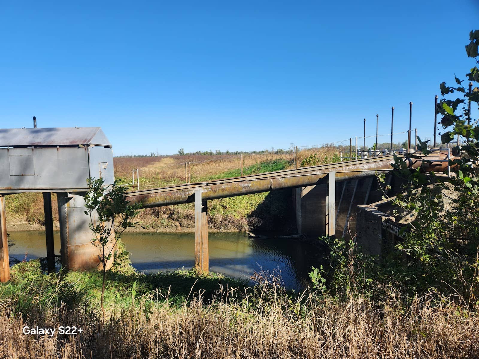
Historic Grain Shut
Near Brownsville
Discover a cool, old grain shut structure where barges used to be loaded.
Shaded Forested Paths
Northern sections
Hike or bike through shaded areas with mature trees, offering a cool escape on warm days.
Plans like a pro.
Thinks like you
Planning Your Visit
Trailhead Location & Access
Trail Conditions & Maintenance
Best Times
Insider Tips
from TikTok, Instagram & Reddit
Hiking with your Dog
I like to camp and go on 1 or 2 backpacking trips each year. Over the past 5-6 months I've been working with my 1 year old pup to walk off-leash. I was hoping to try him out in a backpacking scenario near home before taking him on a larger trip. Anyone know of anything within an…
🎯 Navigate to Trailhead
Don't trust GPS! Drive over RR tracks, turn right at next intersection into gravel lot, walk 0.6 miles.
👟 Watch for Obstacles
Be aware of fallen trees, loose limestone chat, and encroaching weeds, especially for biking.
🐕 Dog-Friendly Exploration
Dogs are welcome, but check leash laws as some areas may not require them.
⚠️ Poison Ivy Alert
Keep an eye out for poison ivy, which can grow near picnic areas and along the trail.
Tips
from all over the internet
🎯 Navigate to Trailhead
Don't trust GPS! Drive over RR tracks, turn right at next intersection into gravel lot, walk 0.6 miles.
👟 Watch for Obstacles
Be aware of fallen trees, loose limestone chat, and encroaching weeds, especially for biking.
🐕 Dog-Friendly Exploration
Dogs are welcome, but check leash laws as some areas may not require them.
⚠️ Poison Ivy Alert
Keep an eye out for poison ivy, which can grow near picnic areas and along the trail.
What Travellers Say
Reviews Summary
Visitors appreciate the natural beauty and potential of the Steamboat Trace Trail, particularly its shaded sections and glimpses of the Missouri River. However, many point out significant issues with trail maintenance, inconsistent upkeep, and confusing trailhead access, which can detract from the overall experience.
"I finished the south of the trail. I did 10.9 mi 2h 58m. Where I parked, the walking bridge was closed off. The trail could use some up keep in a couple of spots. It follows the Missouri River in spots. There is a pretty cool grain shut that comes down where they used to load barges. Lots of wildlife around. Underneath the trail, it has Nebraska City. I was in Brownsville. I'm not sure what I did wrong."
Jerry Dunlap
"As other reviewers noted, the trailhead is not accurately located on Google Maps. Trail conditions between The Auburn Trailhead and Peru were better than I expected. Still lots of black walnuts, fissures and holes so bikers watch out."
Shawn Cavanaugh
"Trailhead parking lot not correctly located on Google Maps. Drive over the railroad tracks to the next road intersection and turn right into the gravel parking lot. Walk the 0.6 miles down the gravel road, cross the abandoned railroad tracks and the trail entrance is on the right. Not well signed at all...we found it recently maintained and a great fast hike mostly in the shade on a warm Nebraska day."
Steve Gunden
What People Like
What People Dislike
Frequently Asked Questions
🚇 🗺️ Getting There
The trailhead parking is not accurately located on Google Maps. Drive over the railroad tracks, turn right at the next road intersection into a gravel parking lot, and walk about 0.6 miles down the gravel road. The trail entrance will be on your right. Look for signs indicating the turn.
Yes, there is a gravel parking lot available. It's located about 0.5 miles further along the gravel road closer to the actual trail start.
Yes, there are multiple access points, including trailheads in Auburn and Peru. However, trail conditions can vary significantly between these points.
Unfortunately, the trail is not always well-signed, especially at the access points. It's recommended to have a map or be prepared to look for subtle cues.
From the parking area, head south on the gravel road. Keep your eyes peeled for a right turn to start the trail, as it's not clearly marked.
🎫 🎫 Tickets & Entry
There is no mention of an entrance fee for the Steamboat Trace Trail, suggesting it is free to access.
The trail is generally open for public access. However, some facilities like restrooms may be locked.
No, tickets are not required for this trail. It's an open public access area for hiking and biking.
Yes, trail closures can occur. One reviewer noted the trail was closed two miles beyond Peru. It's advisable to check for any recent updates if possible.
Since the trail is free and parking is generally available without a fee, no payment is typically required.
🎫 🧭 Onsite Experience
The trail surface varies. Some parts are shaded and well-maintained, while others have loose limestone chat that can be difficult for biking, feeling like 'wet cement' in spots.
Yes, the trail is suitable for hiking. Many sections offer shade and interesting views. However, be prepared for some uneven terrain and potential obstacles.
Reviewers have noted seeing 'lots of wildlife around,' suggesting it's a good spot for nature observation.
Restrooms are available at some trailheads, but they may be locked and appear abandoned. It's best to come prepared.
While dogs are welcome, leash laws can vary. One user inquired about off-leash hiking, suggesting it might be possible in certain sections or areas. It's always best to check local regulations.
📸 📸 Photography
Look for scenic views along the Missouri River, the historic grain shut, and the shaded forest sections. The contrast between open fields and wooded areas can also be photogenic.
The shaded sections offer diffused light, ideal for avoiding harsh shadows. Open areas will have direct sunlight, so early morning or late afternoon light might be best.
Keep an eye out for various local wildlife. The trail's proximity to the river and varied habitats increases the chances of spotting birds and other animals.
The old grain shut near Brownsville is a distinctive feature that makes for interesting photographic subjects.
Early mornings and late afternoons offer softer light and potentially fewer visitors, enhancing the photographic experience.


Social
from TikTok, Instagram & Reddit