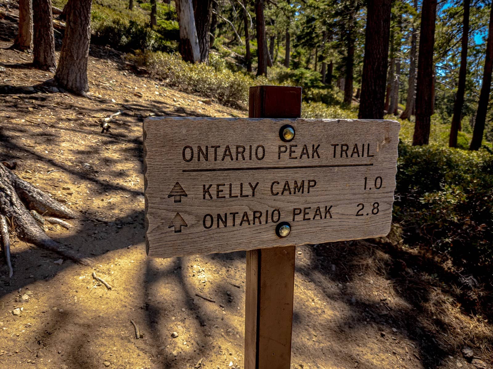
Ontario Peak Trail
Conquer Ontario Peak for breathtaking panoramic views and a challenging, rewarding hike through the San Gabriel Mountains.
Highlights
Must-see attractions

Social
From TikTok & Reddit
Best Time
Beat the crowds and heat
Ontario Peak Trail
Best Time
Beat the crowds and heat
Highlights
Must-see attractions
Conquer Ontario Peak for breathtaking panoramic views and a challenging, rewarding hike through the San Gabriel Mountains.
"The views are quite amazing from the peak."
🚗 Arrive Early for Parking
Parking fills up fast! Aim to arrive before 8 AM, especially on weekends.
📱 Download Offline Maps
Cell service is spotty. Use apps like AllTrails for navigation.
Highlights
Discover the most iconic attractions and experiences
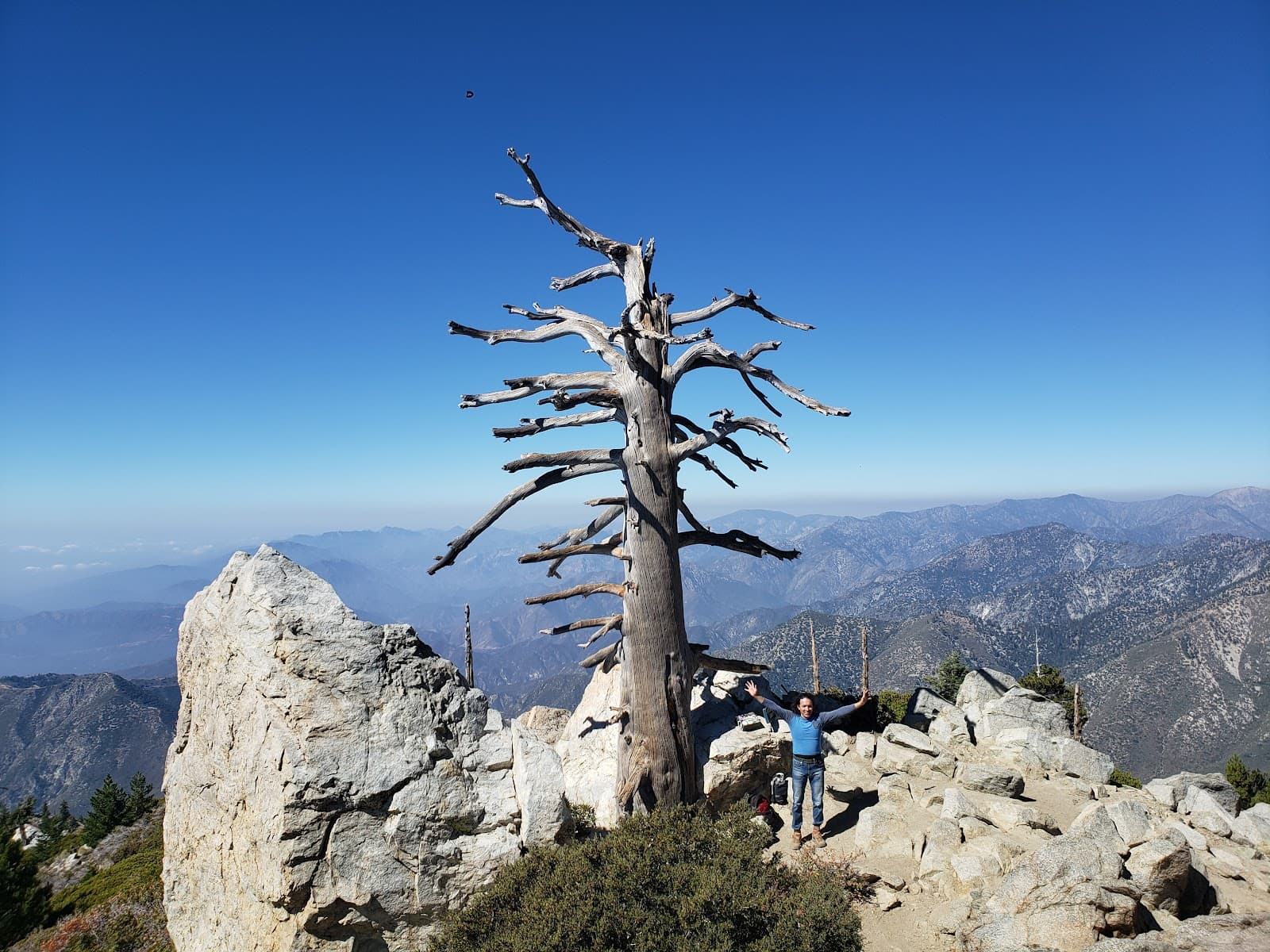
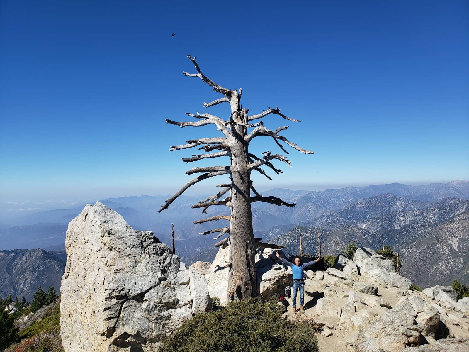
Summit Views
Ontario Peak Summit
Panoramic vistas of surrounding mountains and valleys, often with a 'cloud carpet' effect.
Icehouse Saddle
Junction point on the trail
A scenic resting spot with well-maintained trails leading to multiple peaks.
Winter Wonderland
Various points on the trail
Crisp snow underfoot and stunning winter landscapes, offering a unique hiking experience.
Plans like a pro.
Thinks like you
Planning Your Visit
Timing is Everything
Trail Preparedness
Best Times
Insider Tips
from TikTok, Instagram & Reddit
🚗 Arrive Early for Parking
Parking fills up fast! Aim to arrive before 8 AM, especially on weekends.
📱 Download Offline Maps
Cell service is spotty. Use apps like AllTrails for navigation.
💧 Hydration is Key
Carry plenty of water, as this is a long and strenuous hike.
👟 Sturdy Hiking Boots
Essential for the varied terrain and potential snow/ice.
Tips
from all over the internet
🚗 Arrive Early for Parking
Parking fills up fast! Aim to arrive before 8 AM, especially on weekends.
📱 Download Offline Maps
Cell service is spotty. Use apps like AllTrails for navigation.
💧 Hydration is Key
Carry plenty of water, as this is a long and strenuous hike.
👟 Sturdy Hiking Boots
Essential for the varied terrain and potential snow/ice.
☀️ Sun Protection
The trail is very exposed after 10 AM. Wear sunscreen and a hat.
What Travellers Say
Reviews Summary
Hikers praise the stunning summit views and well-maintained trails, especially from Icehouse Saddle. The challenging yet rewarding nature of the hike is a common theme. Some find the trail less difficult than other local peaks, while others note the significant elevation gain and sun exposure. Occasional mentions of rare atmospheric phenomena like sun halos add to the magic.
"Hiked Cucamonga, Bighorn, and Ontario Peaks from Icehouse Canyon trailhead on a Friday morning in October. Total came to 16.5 miles with 6000 feet elevation gain. If you're coming from Icehouse Canyon trailhead to Icehouse saddle to Ontario peak, expect a 6.5 miles hike with around 3700 feet elevation gain. The trail to Ontario is nice and well-maintained. Had no trouble following it either on my way up from Bighorn or on my way down from Ontario to the trailhead. At the summit, you have a dead tree between a rock pile which also has the boards with the peak's name and elevation on them. To the left of all this is a group of rocks that juts out a bit, and they're worth climbing on - might seem dangerous but nothing tricky - there's enough nice footholds in them."
Vipul Singh
"This peak is one of the nicer peaks in the area and can be accesed by the popular Ontario Peak Trail, which has nice views and has most of the trees blocking it recently cleared, or a scramble up the ridge from Falling Rock Canyon. The views are quite amazing from the peak."
Lily Morgan
"Great View, very well maintained trail from icehouse saddle , easy to follow and only steep in shorter sections.
Very exposed to the sun after 10am but has some shady areas here and there."
Ted Kaufmann
What People Like
What People Dislike
Frequently Asked Questions
🚇 🗺️ Getting There
The most common trailhead is Icehouse Canyon. It's accessible by car, but parking can be extremely limited, especially on weekends. Many hikers recommend arriving very early to secure a spot.
Yes, there is a parking lot at the Icehouse Canyon Trailhead. However, it fills up quickly. Some sources suggest a permit might be needed for parking, so it's wise to check local regulations before you go.
Given the length and potential for trail confusion, using a navigation app like AllTrails is highly recommended. Downloading offline maps is crucial as cell service is unreliable in the area.
Yes, solo hiking is possible and some hikers have reported positive experiences meeting others on the trail. However, always prioritize safety and let someone know your hiking plans.
Information on dedicated shuttle services is limited. Due to parking challenges, carpooling or arriving extremely early are the most common strategies.
🎫 🎫 Tickets & Entry
While specific permits for the trail itself aren't always mentioned, parking at trailheads like Icehouse Canyon may require a permit or Adventure Pass. It's best to verify current requirements with the U.S. Forest Service.
The trail is generally accessible year-round during daylight hours. However, winter conditions can make access difficult or dangerous. Always check current conditions before heading out.
The hike itself is free. However, you may need to purchase an Adventure Pass for parking, which typically costs around $5 per day or $30 annually.
Dogs are generally allowed on the trail but must be kept on a leash at all times. Be mindful of other hikers and the environment.
The Ontario Peak Trail is considered strenuous due to its length and elevation gain. While not as difficult as some other peaks in the area, it's best suited for hikers with some experience.
🎫 🥾 Onsite Experience
The Ontario Peak Trail is typically around 11 to 12 miles roundtrip, depending on the exact route taken from the Icehouse Canyon trailhead.
Expect significant elevation gain, often around 3,700 feet from Icehouse Saddle to Ontario Peak, and potentially up to 6,000 feet if combining with other peaks.
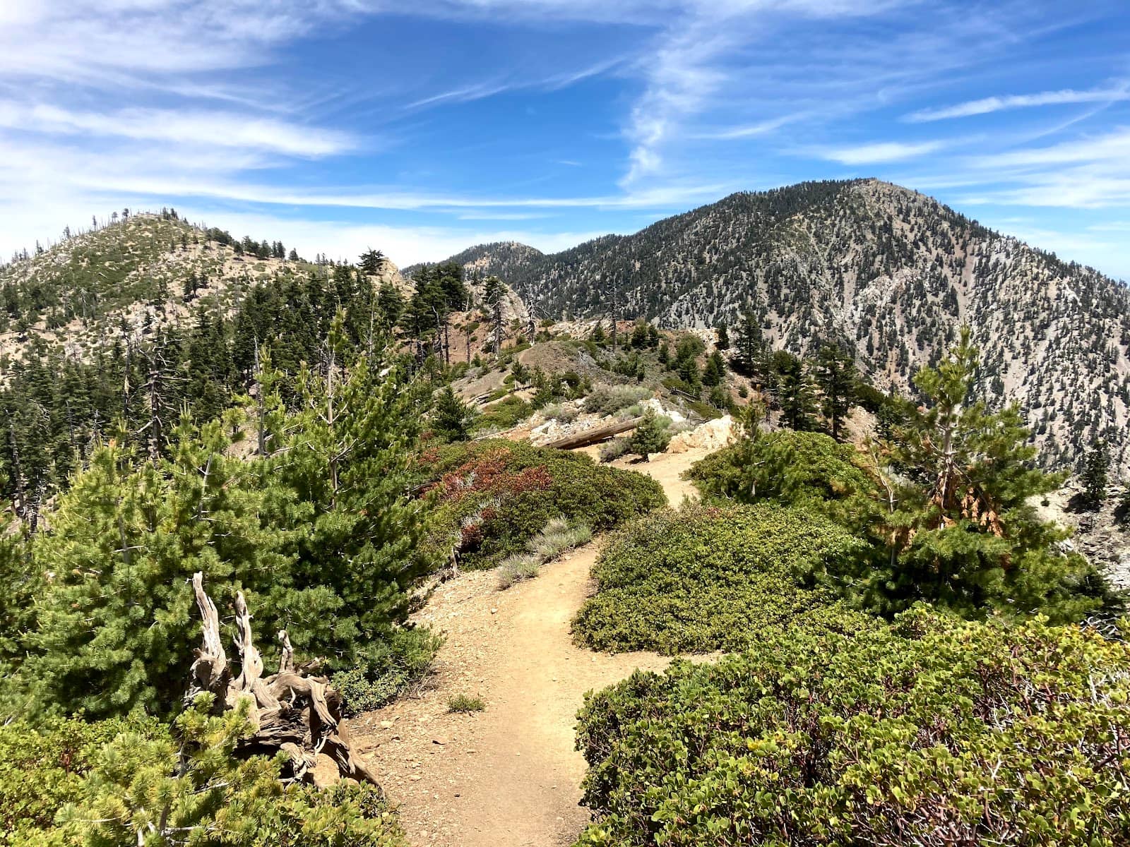
The trail is generally well-maintained, with some steep sections. You'll encounter varied terrain, including dirt paths, rocky areas, and potentially snow and ice in colder months.
The summit typically features a rock pile with peak name markers. There are no facilities like restrooms or water sources at the summit itself.
The views from Ontario Peak are spectacular, offering panoramic vistas of the surrounding San Gabriel Mountains, and on clear days, you can see as far as San Diego.
🍽️ 🍎 Food & Dining
There are no food services directly at the Icehouse Canyon Trailhead. It's essential to pack all your own food and snacks for the hike.
Pack high-energy snacks like trail mix, energy bars, and fruit. For longer hikes, consider sandwiches or other substantial meals. Remember to pack out all trash.
After your hike, you'll need to drive to nearby towns like Claremont or Rancho Cucamonga for a variety of dining options, from casual cafes to sit-down restaurants.
Absolutely. Given the 11-12 mile length of the hike, a packed lunch is highly recommended to keep your energy levels up.
Reliable water sources are scarce on the Ontario Peak Trail. It's crucial to carry all the water you'll need for the entire hike.
📸 📸 Photography
The summit offers breathtaking panoramic views. Other great spots include Icehouse Saddle and any scenic overlooks along the trail, especially during sunrise or sunset. +1
Early morning offers soft light and fewer crowds, while late afternoon can provide beautiful golden hour light. Be aware of sun exposure on the trail.
Drone usage is often restricted in national forests and wilderness areas. Check with the U.S. Forest Service for specific regulations regarding drone operation in this area.
A wide-angle lens is great for capturing the expansive views. A sturdy tripod can be useful for low-light conditions or long exposures. Don't forget extra batteries!
Look out for interesting rock formations, unique trees, and the 'cloud carpet' phenomenon. In winter, snow-covered landscapes and icicles can be stunning.
For Different Travelers
Tailored advice for your travel style
👨👩👧 Families with Kids
If your family is set on tackling a peak, research trails with more manageable distances and elevation profiles. Always prioritize safety and ensure everyone in the group is comfortable with the demands of the hike. The AllTrails app can be a great resource for finding family-friendly alternatives with detailed trail information.
💰 Budget Travelers
To save money, focus on packing your own food and water. Avoid purchasing expensive pre-packaged hiking meals and instead opt for homemade snacks and sandwiches. Carpooling with friends is also a great way to split any potential parking costs and make the journey more economical.
🚶 Solo Adventurers
Utilizing navigation apps like AllTrails is crucial, as cell service can be unreliable. Being prepared with sufficient water, food, and appropriate gear for changing weather conditions will ensure a safer and more enjoyable solo experience.
Deep Dives
In-depth insights and expert knowledge
Navigating the Ontario Peak Trail
Hikers often describe the trail as having gradual elevation gain for much of the ascent, with steeper sections interspersed. The path winds through forests and open slopes, offering changing scenery. Be prepared for exposure to the sun after mid-morning, especially during warmer months. While the trail is generally clear, checking recent trail reports for conditions like snow, ice, or downed trees is always a good practice before your hike.
Solo hikers have reported positive experiences, sometimes meeting fellow adventurers along the way, but it's always wise to inform someone of your plans and carry essential safety gear. The trail can be particularly beautiful in winter, with snow-covered landscapes creating a magical atmosphere, but this also requires appropriate gear and experience.
Summit Views and Photography
For the best photographic opportunities, consider hiking during the golden hours – early morning or late afternoon. The soft light can enhance the dramatic scenery. The 'cloud carpet' effect, where clouds fill the valleys below, is a particularly sought-after sight and can create stunning visual compositions.
When planning your photography, remember that the trail is quite exposed to the sun, especially after 10 AM. This means you'll need to be mindful of harsh lighting conditions if you're hiking mid-day. Bringing a wide-angle lens is ideal for capturing the vastness of the views, and a sturdy tripod can be beneficial for capturing the best shots, especially in varying light.
Winter Hiking on Ontario Peak
However, winter conditions also bring increased challenges. Snow and ice can make the trail slippery and more difficult to navigate, requiring appropriate gear such as microspikes or crampons, and trekking poles. Checking weather forecasts and trail conditions is absolutely critical before embarking on a winter hike. The U.S. Forest Service can provide up-to-date information on avalanche risks and trail accessibility.
Despite the challenges, many hikers find the winter beauty of Ontario Peak incredibly rewarding. The solitude and the pristine snowscapes offer a unique sense of accomplishment and connection with nature. It's an experience that requires careful preparation but can be unforgettable.
Social
from TikTok, Instagram & Reddit