
Brad Freeman Trail
A 41-mile scenic trail along the Feather River, perfect for hiking and cycling, featuring a historic train tunnel.
Highlights
Must-see attractions

Social
From TikTok & Reddit
Best Time
Pleasant temperatures for hiking
Brad Freeman Trail
Best Time
Pleasant temperatures for hiking
Highlights
Must-see attractions
A 41-mile scenic trail along the Feather River, perfect for hiking and cycling, featuring a historic train tunnel.

🗺️ Download Trail Map
Carry a detailed brad freeman trail map, as cell service can be spotty.
💧 Hydration is Key
Bring ample water, especially for longer hikes; there are limited refill stations.

Quick Facts
Highlights
Discover the most iconic attractions and experiences
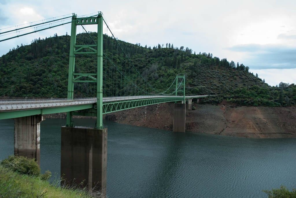
Feather River Views
Along the entire trail
Experience breathtaking vistas of the Feather River, a constant companion on this scenic route.
Historic Train Tunnel
Specific section of the trail
Discover a unique, historic train tunnel, adding an element of intrigue to your journey.
Plans like a pro.
Thinks like you
Planning Your Visit
Trail Length & Preparation
Best Access Points
Best Times
Insider Tips
from TikTok, Instagram & Reddit
🗺️ Download Trail Map
Carry a detailed brad freeman trail map, as cell service can be spotty.
💧 Hydration is Key
Bring ample water, especially for longer hikes; there are limited refill stations.
👟 Wear Comfortable Shoes
Sturdy hiking boots or athletic shoes are recommended for the varied terrain.
☀️ Sun Protection
Use sunscreen, hats, and sunglasses; much of the trail is exposed.
Tips
from all over the internet
🗺️ Download Trail Map
Carry a detailed brad freeman trail map, as cell service can be spotty.
💧 Hydration is Key
Bring ample water, especially for longer hikes; there are limited refill stations.
👟 Wear Comfortable Shoes
Sturdy hiking boots or athletic shoes are recommended for the varied terrain.
☀️ Sun Protection
Use sunscreen, hats, and sunglasses; much of the trail is exposed.
What Travellers Say
Reviews Summary
The Brad Freeman Trail is praised for its extensive length and beautiful Feather River scenery, offering great opportunities for hiking and cycling. While generally well-maintained, visitors note the importance of planning for water and navigation due to the trail's 41-mile span and limited services.
What People Like
What People Dislike
Frequently Asked Questions
🚇 🗺️ Getting There
The Brad Freeman Trail is located in Oroville, California. Several access points exist along its 41-mile length. Popular starting points include areas near the Feather River and various parks. It's recommended to consult a brad freeman trail map for specific entry locations and parking information.
Yes, parking is available at various access points along the trail. However, availability can vary, especially on weekends or during peak seasons. Arriving early is advisable.
Public transportation options to the immediate trailheads are limited. It's generally recommended to drive to one of the designated access points.
Using a detailed brad freeman trail map is essential. While some sections are well-marked, the trail's length means having a map, whether digital or physical, is crucial for navigation and planning your route.
For beginners, it's best to choose shorter, more accessible sections of the trail. Researching specific access points on a brad freeman trail map will help you find suitable starting points with easier terrain.
🎫 🎫 Tickets & Entry
No, the Brad Freeman Trail is generally open to the public and does not require an admission ticket for access. Enjoying the scenic beauty is free!
The trail is typically open from dawn to dusk. However, specific access points or adjacent park areas might have their own operating hours, so it's wise to check local park information.
Access to the Brad Freeman Trail itself is free. Parking at some trailheads might be subject to local park fees, so it's good to be prepared for that possibility.
Reservations are not required for the Brad Freeman Trail as it's an open public trail. You can visit anytime during its operating hours.
Generally, no special permits are required for day use of the Brad Freeman Trail. However, if you plan on any organized group events or specific activities, it's best to check with local authorities.
🎫 🏞️ Onsite Experience
The Brad Freeman Trail is perfect for hiking, jogging, and cycling. Its length and varied terrain offer opportunities for both leisurely strolls and more challenging endurance activities.
While parts of the trail are suitable, its 41-mile length means families should plan for shorter, manageable sections. Consider the terrain and ensure children are supervised.
Restroom availability can be limited and is usually concentrated near major access points or parks. It's advisable to use facilities before starting your hike.
The terrain varies, featuring paved sections, gravel paths, and some natural surfaces. It's generally well-maintained but can include some inclines and declines.
Dogs are generally allowed on the Brad Freeman Trail, but they must be kept on a leash at all times. Always check local park regulations for any specific restrictions.
📸 📸 Photography
The trail offers stunning views of the Feather River, scenic bridges, and the unique historic train tunnel. Capture the natural beauty and any interesting man-made structures.
Early morning or late afternoon, during the 'golden hours,' provides the best natural light for photography, minimizing harsh shadows and enhancing the landscape's colors.
Drone usage is often restricted in parks and natural areas. It's crucial to check with local authorities or park management regarding drone regulations before flying.
A versatile camera with a good zoom lens is ideal for capturing both wide landscapes and details. A wide-angle lens is great for the expansive river views.
Look for elevated spots along the trail that offer panoramic views of the Feather River. The area around the train tunnel also presents unique photographic possibilities.

Social
from TikTok, Instagram & Reddit