St. Francis Dam Disaster Site and Monument
Commemorates the devastating 1928 St. Francis Dam collapse, a major civil engineering failure and tragedy in California history.
Highlights
Must-see attractions

Social
From TikTok & Reddit
Best Time
Fewer crowds, more peaceful reflection
St. Francis Dam Disaster Site and Monument
Best Time
Fewer crowds, more peaceful reflection
Highlights
Must-see attractions
Commemorates the devastating 1928 St. Francis Dam collapse, a major civil engineering failure and tragedy in California history.
"A somber yet essential visit to understand a critical moment in California's water history and engineering."

🚗 Drive Safely
The site is remote. Ensure your vehicle is in good condition and you have enough fuel.
🚶♀️ Wear Sturdy Shoes
You'll be walking on uneven terrain among the ruins. Comfortable, closed-toe shoes are a must.
Quick Facts
Rating
4.6 · 73 reviews
Type
Historical Place
Highlights
Discover the most iconic attractions and experiences
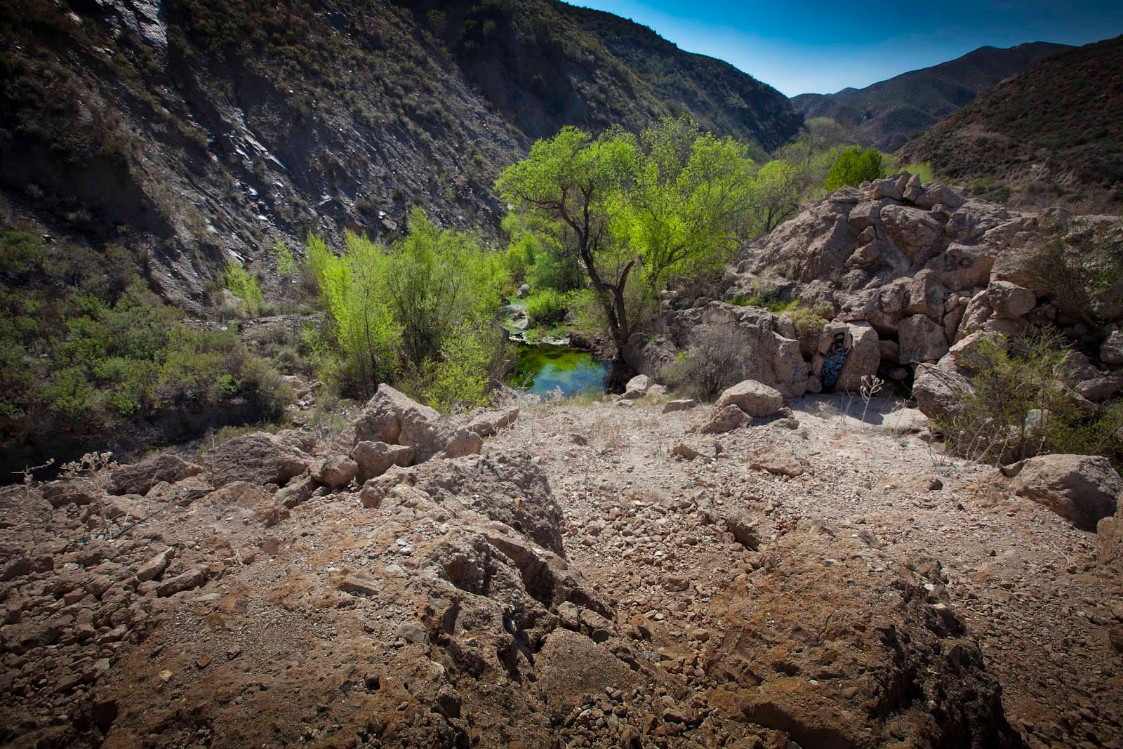
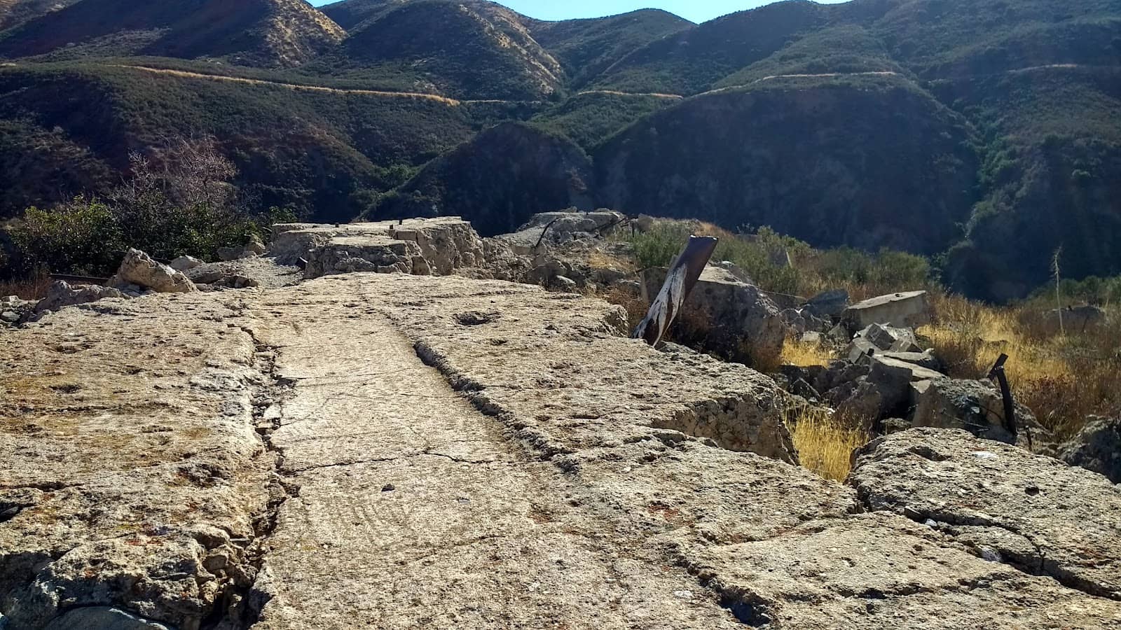
Dam Ruins
Near Castaic Creek
Walk among the massive, scattered concrete blocks that were once the St. Francis Dam. A stark reminder of the disaster.
Interpretive Plaque
Near Pump Station 2
Detailed historical account of the dam's construction, failure, and the catastrophic flood that followed.

Monument and Memorial
Near the dam site
A place for quiet reflection and to pay respects to the over 450 souls lost in the 1928 flood.
Plans like a pro.
Thinks like you
Planning Your Visit
Understand the Tragedy
Prepare for a Remote Visit
Best Times
Insider Tips
from TikTok, Instagram & Reddit
🚗 Drive Safely
The site is remote. Ensure your vehicle is in good condition and you have enough fuel.
🚶♀️ Wear Sturdy Shoes
You'll be walking on uneven terrain among the ruins. Comfortable, closed-toe shoes are a must.
The St. Francis Dam, created by the Los Angeles County Water and Power company as part of the California aqueduct system, collapsed at 11:58 pm on March 12, 1928, making it the was the worst manmade disaster in California history
Ask a Mortician on YouTube did a pretty great video on the disaster. Great watch if you've got the time
📚 Research Before You Go
Understanding the history enhances the visit. Watch documentaries or read up on the disaster.
💧 Bring Water
There are no facilities on-site, so pack plenty of water, especially on warmer days.
Tips
from all over the internet
🚗 Drive Safely
The site is remote. Ensure your vehicle is in good condition and you have enough fuel.
🚶♀️ Wear Sturdy Shoes
You'll be walking on uneven terrain among the ruins. Comfortable, closed-toe shoes are a must.
📚 Research Before You Go
Understanding the history enhances the visit. Watch documentaries or read up on the disaster.
💧 Bring Water
There are no facilities on-site, so pack plenty of water, especially on warmer days.
📸 Capture the Scale
The sheer size of the concrete debris is astonishing. Try to capture the scale in your photos.
What Travellers Say
Reviews Summary
Visitors find the St. Francis Dam site a profoundly moving and historically significant location, offering a tangible connection to a major California disaster. The scattered ruins and interpretive signs provide a stark reminder of engineering failures and the lives lost. While the remote setting and lack of extensive facilities are noted, the educational value and somber atmosphere are highly appreciated.
"Interpretive sign text:
Construction of the Dam.
Problems With Design.
Too Tall.
Final design was 20 ft higher than the original plan, without increasing the base width to support the additional height.
Hydraulic Uplift.
The design did not include enough design features to account for uplifting pressure beneath the structure due to buoyancy.
No Contraction Joints.
Contraction joints are grooves in concrete structures purposefully created during construction to control the location of cracks as the concrete dries.
Processes Not In Place at the Time.
No External Review.
Mulholland had his own staff perform all the engineering calculations without external review.
Concrete Missteps.
The aggregate for the concrete was neither washed nor sorted to remove unwanted substances like silt or clay, which reduce the quality.
Poor Site Location.
The dam was partially built on an ancient landslide, which shifted under the massive weight of the dam."
Craig Baker
"It's important we visit these sites of historical reference, no matter the tragedy. The souls lost that night in March 1928 are quiet. I feel they have peace as more people come to pay respects."
Cheryl Tate
"I've been here many times but this is the first time I had a guided tour from a recognized expert. This is a very important historical point of interest and is now a National Historic Monument Someday there will be a visitor center and it will be much more crowded. So that you understand our history."
Patrick Comey
What People Like
What People Dislike
Frequently Asked Questions
🚇 🗺️ Getting There
The site is located north of Santa Clarita, California. It's a drive off I-5. Visitors often mention it's a bit of a drive but accessible.
Public transportation options are very limited due to the remote location. Driving is the most practical way to reach the site.
From Los Angeles, take I-5 North and exit towards Castaic. Follow local roads towards the dam site. It's recommended to use GPS.
Limited parking is available near the interpretive signs and the main monument area. Be prepared for potentially rougher ground.
The site is approximately 15-20 miles north of Santa Clarita, depending on the exact route taken.
🎫 🎫 Tickets & Entry
No, entry to the St. Francis Dam Disaster Site and its monument is free. It's an open historical site.
As an outdoor historical site, there are no official operating hours. Visitors can typically access it during daylight hours.
There is no entrance fee. The site is maintained as a historical landmark for public access and remembrance.
While accessible, it's best to visit during daylight hours for safety and to better view the ruins and interpretive signs.
While there are no explicit restrictions mentioned, visitors are advised to be respectful of the historical nature of the site and exercise caution when exploring the ruins.
🎫 🧭 Onsite Experience
You can see the remnants of the dam, including large concrete blocks scattered downstream, interpretive signs detailing the disaster, and a monument.
Most visitors spend 1-2 hours exploring the site, reading the signs, and walking among the ruins.
Occasionally, guided tours are offered by historical experts. It's advisable to check local historical society listings for availability.
The site is educational but somber. Parents should supervise children closely due to uneven terrain and the tragic history.
Expect uneven ground, loose rocks, and potentially sandy or dusty areas. Sturdy footwear is essential.
📸 📸 Photography
The scattered concrete blocks offer dramatic photo opportunities. The interpretive signs and monument also provide context.
Yes, photography is allowed. It's a historical site, and capturing its essence is encouraged.
A wide-angle lens can help capture the scale of the ruins. A standard zoom is also versatile. Consider a tripod for low-light conditions.
Regulations regarding drone usage can vary. It's best to check current FAA and local park rules before flying a drone.
Golden hour (early morning or late afternoon) can provide dramatic lighting for the ruins and landscape.


Social
from TikTok, Instagram & Reddit