
Mount Eagle Trail
Hike to breathtaking panoramic views of Puerto Rico and the Virgin Islands, navigating a challenging road and lush trails.
Highlights
Must-see attractions

Social
From TikTok & Reddit
Best Time
Best chance for island views
Mount Eagle Trail
Best Time
Best chance for island views
Highlights
Must-see attractions
Hike to breathtaking panoramic views of Puerto Rico and the Virgin Islands, navigating a challenging road and lush trails.
"The views from the top make the rough road and spider webs totally worth it!"
🚗 Park Smartly
Park near the last house on Scenic Road to avoid the roughest road sections. Adds about a mile to your hike.
🕷️ Web Watch!
Be mindful of large spider webs across the path. Use a twig to gently clear them.
Quick Facts
Rating
4.7 · 3 reviews
Type
Hiking Area
Highlights
Discover the most iconic attractions and experiences
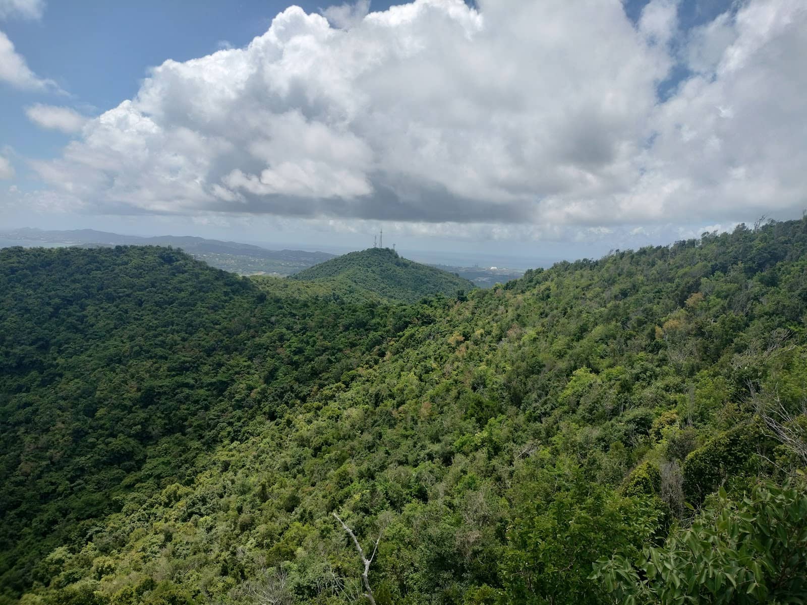
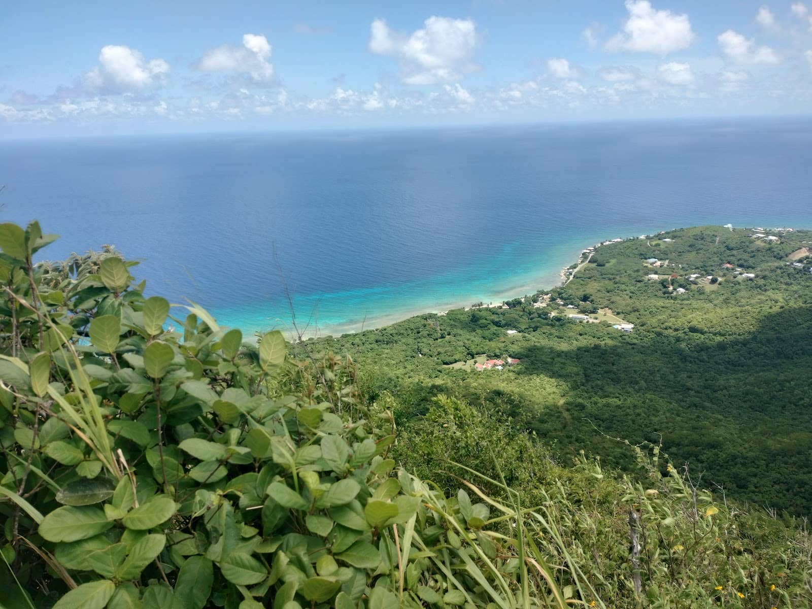
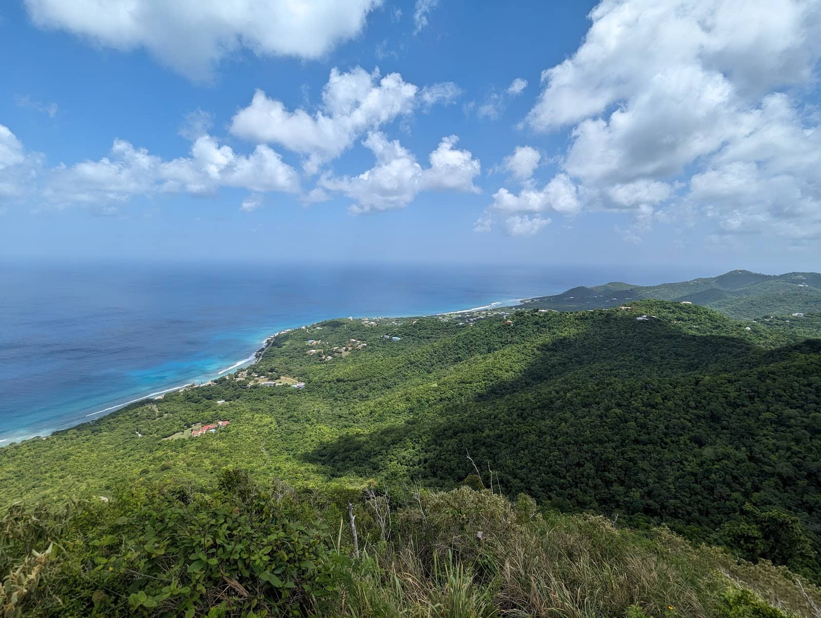
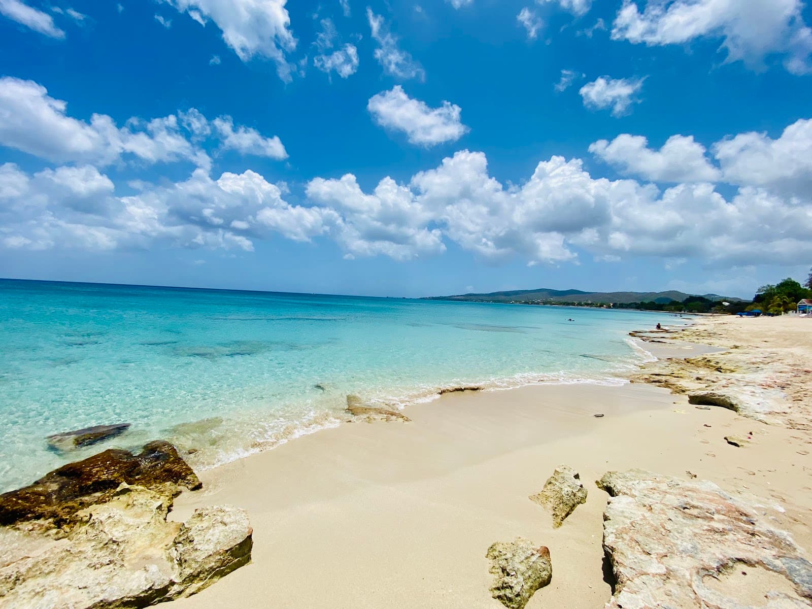
Panoramic Summit Views
Summit
Breathtaking 360-degree views of Puerto Rico and surrounding Virgin Islands on clear days. Truly the island's best vista.
Abundant Butterfly Sightings
Forested areas
The lush, forested sections are alive with beautiful butterflies, adding a vibrant touch to your hike.
Orb-weaver Spider Webs
Forested sections
Encounter impressive, large orb-weaver spider webs that are a fascinating part of the trail's ecosystem.
Plans like a pro.
Thinks like you
Planning Your Visit
Road to the Trailhead
Trail Conditions & Wildlife
Best Times
Insider Tips
from TikTok, Instagram & Reddit
🚗 Park Smartly
Park near the last house on Scenic Road to avoid the roughest road sections. Adds about a mile to your hike.
🕷️ Web Watch!
Be mindful of large spider webs across the path. Use a twig to gently clear them.
💧 Bring Plenty of Water
Stay hydrated, especially on warmer days. A snack for the summit is a great idea!
⚠️ Wasp Nest Awareness
Watch out for wasp nests at face height in forested areas to avoid stings.
Tips
from all over the internet
🚗 Park Smartly
Park near the last house on Scenic Road to avoid the roughest road sections. Adds about a mile to your hike.
🕷️ Web Watch!
Be mindful of large spider webs across the path. Use a twig to gently clear them.
💧 Bring Plenty of Water
Stay hydrated, especially on warmer days. A snack for the summit is a great idea!
⚠️ Wasp Nest Awareness
Watch out for wasp nests at face height in forested areas to avoid stings.
👟 Sturdy Footwear Recommended
While not strenuous, the trail can be overgrown. Good shoes offer comfort and stability.
What Travellers Say
Reviews Summary
Mount Eagle Trail offers incredible summit views that make the journey worthwhile, despite challenging road access and overgrown paths. Visitors appreciate the panoramic vistas of Puerto Rico and surrounding islands, as well as the natural beauty of butterflies and unique spider webs. However, the rough road to the trailhead and the presence of insects like spiders and wasps require preparedness and caution.
"I drove from the Cane Bay area and parked about a mile East of the trailhead along the side of the road. The West Scenic Road is rough with many washouts, there is no chance of driving up to the trailhead without an off-road Jeep. This added a mile to my hike. The trail itself is not strenuous, but was quite overgrown in spots, and is mostly forested. There are large orb weave spiders (harmless) in the forested areas, along with plenty of beautiful butterflies. The views from the top make it worth the effort! Great views of Puerto Rico and the other Virgin Islands if you venture up on a clear day like I did."
Andrew Strand
"The trail itself is one of the easier St Croix hikes. No switch backs or steep paths...Be aware there can be quite a few spiders and wasps nests at face height. The spiders aren't harmful, but build large webs across the path, it's easy to move them with a twig. The jack spaniel wasps can sting and cause some pain and discomfort for days so be aware and avoid them.
The road to the trail head/parking area is terrible, so I wouldn't even go further than the last house on Scenic road when approaching from the east. If you approach from the west, the walk on scenic is pretty far and you'll have to park at the top of the beast.
Bring water, and perhaps a sandwich to eat at the best view on island!"
Julia Edwards
"Rating this as a hard trail simply because of the drive and the baseball sized spiders. It's still a fun hike and the view at the end is wonderful"
Kevin Swoboda
What People Like
What People Dislike
Frequently Asked Questions
🚇 🗺️ Getting There
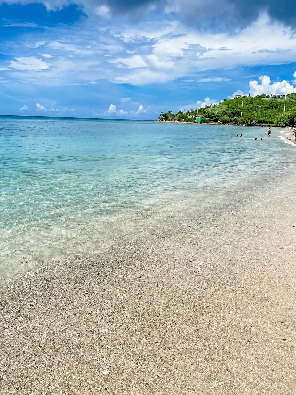
Accessing the trailhead can be challenging. The West Scenic Road is often rough with washouts, making it difficult for standard vehicles. Many visitors park about a mile east of the trailhead along the road and walk the rest of the way. If approaching from the west, the walk on Scenic Road can be quite long, and you might need to park at the top of the 'beast' (likely referring to a steep section).
It's generally not recommended to drive all the way to the trailhead with a standard vehicle due to rough road conditions and washouts. Parking further down the road is a common strategy.
An off-road capable vehicle like a Jeep might be able to navigate the rougher sections of the West Scenic Road. However, for most visitors, parking a mile or so away is the most practical solution.
While there might be limited parking closer to the trailhead, it's often inaccessible. Many hikers opt to park along the side of the road about a mile before the trailhead.
If you park about a mile east of the trailhead, you'll add approximately one mile to your hike each way.
🎫 🎫 Tickets & Entry
There is no mention of an entrance fee for Mount Eagle Trail, suggesting it is a free public access area. +1
As an outdoor trail, Mount Eagle Trail is generally accessible during daylight hours. It's advisable to plan your hike to allow ample time before sunset.
No advance booking or tickets are required for Mount Eagle Trail, as it is an open-access hiking area. +1
The trail itself is described as not strenuous with no steep paths, making it relatively easy. However, the overgrown sections, spiders, and potential wasp nests might require caution for very young children or those with phobias.
For the best views of Puerto Rico and the surrounding islands, aim for a clear morning. Late afternoon can offer beautiful golden hour light on the landscape.
🎫 🥾 Onsite Experience
The trail itself is considered easy to moderate, with no steep switchbacks. However, the overgrown sections and the added distance from parking can increase the overall effort. +1
You'll likely encounter large orb-weaver spiders and their webs in the forested areas. Plenty of beautiful butterflies are also common sightings. Be aware of potential wasp nests. +1
There are no specific facilities mentioned for Mount Eagle Trail, so come prepared with your own water and snacks.
Wear comfortable, sturdy hiking shoes or boots. Lightweight, breathable clothing is recommended, and consider long sleeves or pants to protect against overgrowth and insects.
The hike itself is not strenuous, but the time can vary depending on how far you have to park and how much time you spend enjoying the summit views. Allow at least 2-3 hours for the round trip, including the walk from the car.
📸 📸 Photography
The summit offers unparalleled panoramic views of Puerto Rico and the Virgin Islands, making it the prime spot for photography, especially on a clear day. The lush, forested sections with butterflies and spider webs also provide unique photographic subjects.
Sunrise and sunset can offer beautiful lighting for photos, particularly at the summit. However, ensure you are aware of the trail conditions and have adequate lighting if hiking during these times.
A wide-angle lens is ideal for capturing the expansive summit views. A macro lens can be useful for photographing the butterflies and spider webs. Don't forget a sturdy tripod if you plan on shooting during low light conditions.
No specific photography restrictions are mentioned for Mount Eagle Trail. However, always be respectful of the natural environment and any other visitors.
The best time for photography is during clear weather, which can occur year-round. However, the dry season might offer more consistent clear skies for optimal views.


Social
from TikTok, Instagram & Reddit