Pinhatt Mountain
A wild, rewarding hike near Da Lat with stunning summit views and a unique maple forest, perfect for nature lovers seeking an off-the-beaten-path adve...
Highlights
Must-see attractions

Social
From TikTok & Reddit
Best Time
Best before afternoon rain
Pinhatt Mountain
Best Time
Best before afternoon rain
Highlights
Must-see attractions
A wild, rewarding hike near Da Lat with stunning summit views and a unique maple forest, perfect for nature lovers seeking an off-the-beaten-path adventure.
"The view from the mountain is really beautiful, forest around is very interesting and has mapple trees. "
🗺️ Use Offline Maps
Google Maps doesn't show the trail. Use Strava, AllTrails, or Maps.me for accurate navigation. :iphone:
🦟 Bug Spray is Essential
Lots of flies and bugs, so bring repellent. Long clothing is also recommended. :smilingfacewith_tearss:
Quick Facts
Highlights
Discover the most iconic attractions and experiences
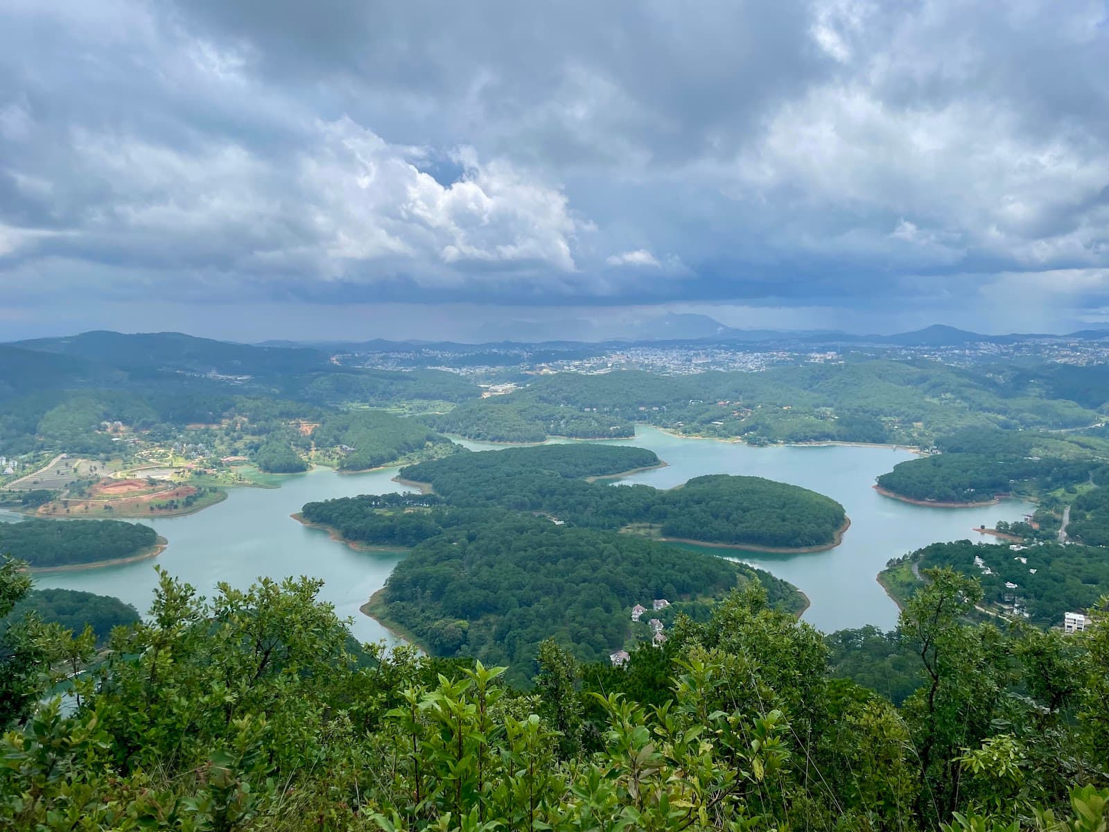
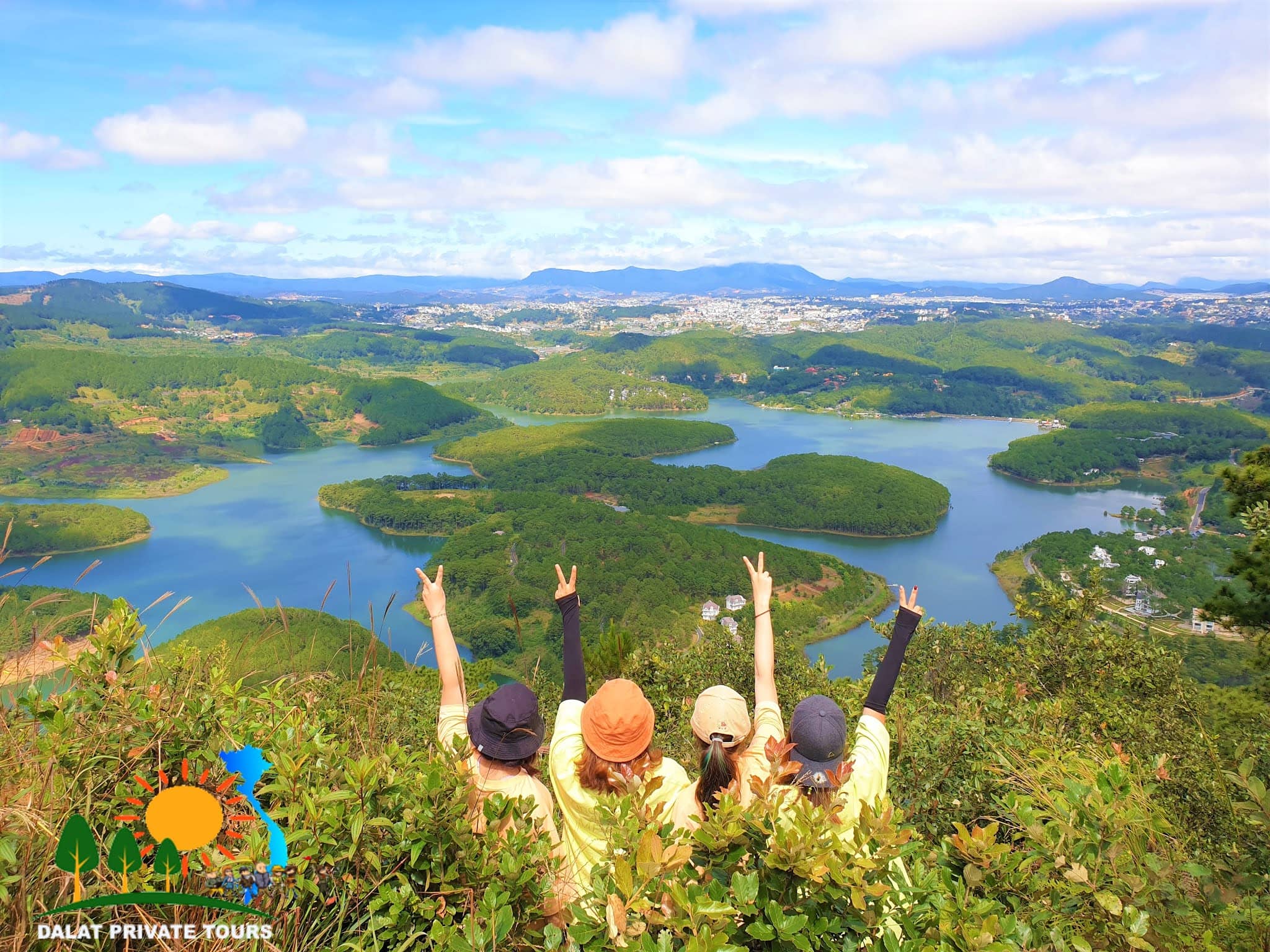
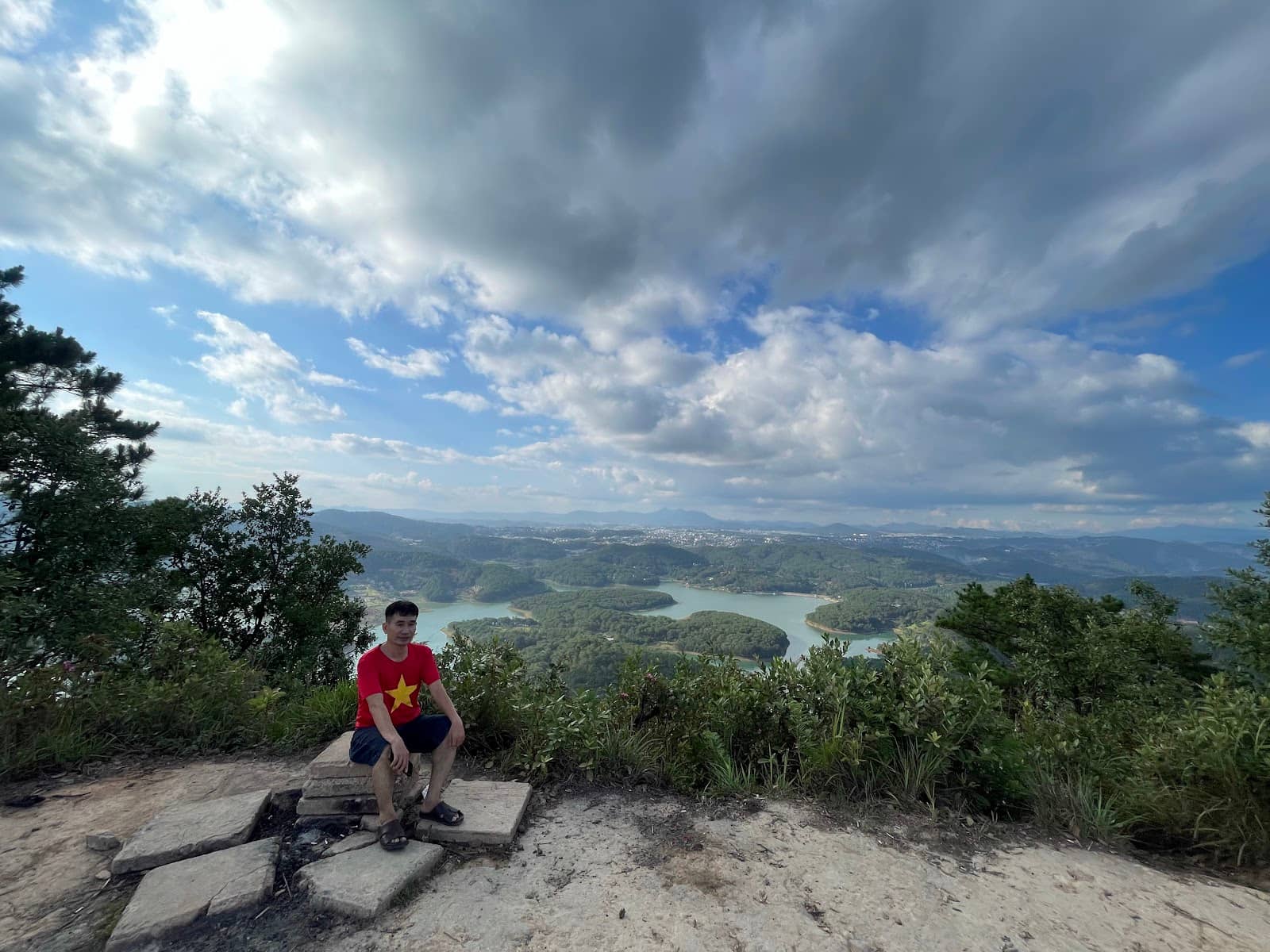
Panoramic Summit Views
Summit
Breathtaking vistas of the surrounding forests and Da Lat landscape await at the peak.
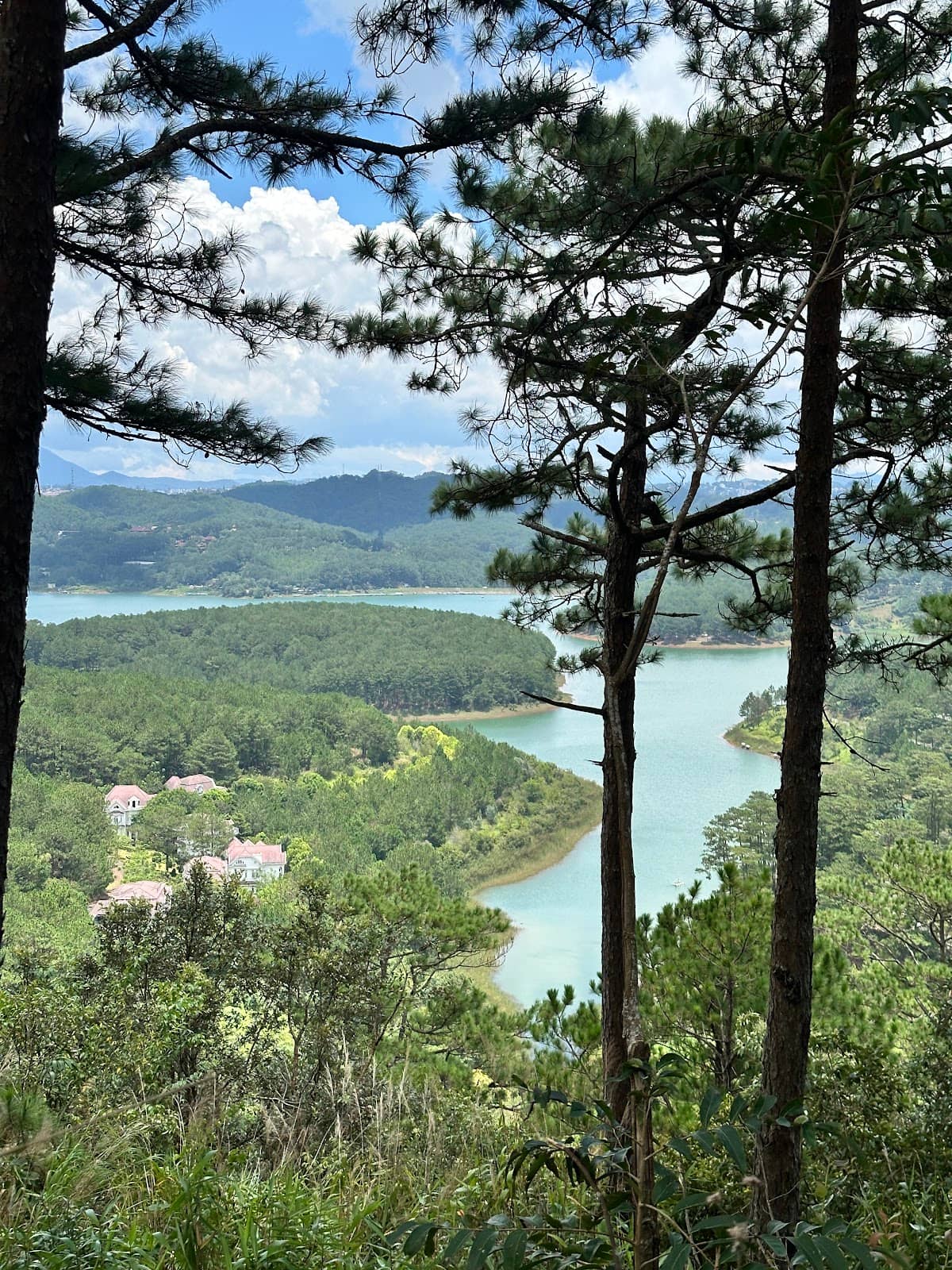
Maple Tree Forest
Trail
Wander through an interesting forest with beautiful maple trees, offering a unique sensory experience.

Nature Immersion
Trail
Experience forest bathing with bird songs and a mix of tropical and pine scents.
Plans like a pro.
Thinks like you
Planning Your Visit
Navigating the Trail
Gear Up for Nature
Best Times
Insider Tips
from TikTok, Instagram & Reddit
🗺️ Use Offline Maps
Google Maps doesn't show the trail. Use Strava, AllTrails, or Maps.me for accurate navigation. :iphone:
🦟 Bug Spray is Essential
Lots of flies and bugs, so bring repellent. Long clothing is also recommended. :smilingfacewith_tearss:
🥾 Sturdy Footwear Needed
Hiking shoes are best for steep and potentially slippery parts, especially after rain. :athletic_shoe:
⬆️ First Right Turn
About 200m in, take a hard right. This is the start of the main trail. :arrowheadingup:
Tips
from all over the internet
🗺️ Use Offline Maps
Google Maps doesn't show the trail. Use Strava, AllTrails, or Maps.me for accurate navigation. :iphone:
🦟 Bug Spray is Essential
Lots of flies and bugs, so bring repellent. Long clothing is also recommended. :smilingfacewith_tearss:
🥾 Sturdy Footwear Needed
Hiking shoes are best for steep and potentially slippery parts, especially after rain. :athletic_shoe:
⬆️ First Right Turn
About 200m in, take a hard right. This is the start of the main trail. :arrowheadingup:
⚠️ Private Land Caution
The trail may cross private land. Be aware of potential access issues or warnings. ⚠️
What Travellers Say
Reviews Summary
Pinhatt Mountain offers a rewarding hike with spectacular summit views and a unique forest experience, though it requires preparation for overgrown trails and abundant insects. Some visitors note potential access issues on private land and the lack of official mapping.
"TL;DR: A pretty desolate trail that’s weedy and buggy, but relatively easy.
Summit altitude: ~1,750m
Elevation gain: 268m
Distance to summit: 1.65km
Time to summit: 30-40 mins
I did this on a Saturday afternoon. Took a Grab to Sacom Resort - the entrance is a barbed wire fence next to a signboard, across the resort entrance guardhouse. Pic 1 is the start of the trail. It’s weedy, and it gets weedier 🙃 this trail isn’t on google maps - Strava / AllTrails show it.
➡️ Take a hard right 200m in.
A thick fog started descending the moment I entered (I think I’m cursed*), and all I got to show for the climb was Pic 2, taken 10 mins in.
Trail path was clearly marked, so no concerns getting lost. I’d recommend hiking shoes because there are fairly steep portions, and wearing longs entirely (maybe even a hood) because bugs.
I’m not big on out and back trails so I didn’t feel like doing the descent… also because I was afraid of snakes going up lol (fear was unfounded thankfully). And the fog I attracted* was becoming a drizzle so I decided to check out the road path instead.
🛣️ Road to Happy Hill was a 45 min leisurely walk downhill, and it was just as desolate as the forest was, except the only danger was stepping on buffalo poo 💩. No animals sighted.
Upon arriving I was greeted with locked gates and barbed wire. Fortunately there was a slope on the side (my right) and I used a rotten stick to aid my descent. Was seen and scolded in Vietnamese by a man I’m assuming is the guard. Well it was either a reprimand or haughty admiration — maybe I’ll assume it’s the latter 😁
Walked the road loop and arrived back at Sacom Resort for a 7km loop.
*Predictably… the skies cleared considerably upon exit. ⛅️
Maybe I’ll try again…"
Grace Lim
"Amazing hike, highly recommend. Park at the bottom by Sacom Resort- looks a bit derelict but my scooter was fine. Start walking up and turn at the first right you come to- about 200m in. The view is incredible, the walk isn’t too bad just steep on the steep parts. Overall it was exactly 3.5km taking 35 minutes to get up and 25 minutes to get down as it can be quite slippery after rainfall.
I found if you track it on Strava it shows the actual path so you cannot go wrong at the first turning point. Google maps doesn’t show the trail.
Lots of flies and bugs so recommend bringing bug spray. Also the plants overhanging the path can be quite sharp as I got scratched a couple of times."
Emily Fletcher
"We hiked this on 11th August 2025. Weather was fine in the morning which is the best time before the rain. Saw no one except another western couple. We started from Sacom resort entrance and parked our scooter under some shade. Good trail, easy to follow and only a little bit overgrown. Not muddy, not too many mosquitoes and we saw no leeches. Trail is well marked on maps.me app so highly recommend using that as it’s not shown on google maps. Great view from the top and well worth the effort. Took us 1hr plus 15min break at the top, so not a long walk (We’re in our mid-30s with decent fitness). Not too steep so ok in the knees. Well shaded along the trail except at the top. Trekking sandals worked fine for us in the dry."
Tom & Cloé Arnold
What People Like
What People Dislike
Frequently Asked Questions
🚇 🗺️ Getting There
Take a Grab to Sacom Resort. The trail entrance is a barbed wire fence next to a signboard, across the resort entrance guardhouse.
No, Pinhatt Mountain trail is not shown on Google Maps. You'll need to use other navigation apps like Strava, AllTrails, or Maps.me.
You can park your scooter at the bottom by Sacom Resort. The resort itself might look a bit derelict, but scooters are generally safe.
Using an app like Maps.me is highly recommended as it shows the actual path, preventing you from getting lost.
Some reviews mention taking a shortcut through the jungle if the main road is blocked, but this is not recommended without a guide.
🎫 🎫 Tickets & Entry
There's no mention of tickets or entry fees. However, some parts might be considered private land, so be mindful of any local guidance.
There are no official opening hours. It's best to visit during daylight hours, ideally in the morning before potential afternoon rain.
Some reviews indicate the trail might be technically closed or on private land, requiring you to climb over barbed wire. Be prepared for this possibility.
It's not recommended to hike at night due to the lack of clear markings on Google Maps and potential safety concerns. Stick to daylight hours.
While not explicitly stated, be respectful of the environment and any private land boundaries. Avoid littering and stay on marked paths where possible.
🎫 🥾 Onsite Experience
The hike to the summit typically takes 30-40 minutes, with the descent being slightly quicker (around 25 minutes) if conditions are dry.
The hike is considered relatively easy to moderate, with some steep portions. It's about 1.65km to the summit with 268m elevation gain.
Wear long clothing to protect against bugs and sharp plants. Hiking shoes are recommended for grip on steep sections.
Yes, expect plenty of flies and bugs. Bringing insect repellent is highly advised.
The trail can be weedy and a bit overgrown, but it's generally clearly marked. Some parts might be sharp due to overhanging plants.
📸 📸 Photography
The summit offers spectacular panoramic views. The maple tree forest also provides beautiful photographic opportunities.
Mornings offer clearer skies before potential afternoon rain. Golden hour light could also be beautiful, but check weather conditions.
There are no specific regulations mentioned, but be mindful of private land and any local restrictions. Always fly responsibly.
Expect lush forests with a mix of tropical and pine trees, including maple trees, and expansive views from the summit.
The blend of forest types and the potentially misty atmosphere can create unique and atmospheric shots.


Social
from TikTok, Instagram & Reddit