
Galloping Goose Trail
A 55km multi-use trail offering scenic woodland and coastal views, perfect for biking, walking, and running.

Highlights
Must-see attractions

Social
From TikTok & Reddit
Best Time
Mild weather, fewer crowds
Galloping Goose Trail
Best Time
Mild weather, fewer crowds
Highlights
Must-see attractions
A 55km multi-use trail offering scenic woodland and coastal views, perfect for biking, walking, and running.
"Amazingly well-maintained and well-serviced route from Victoria to the beautiful Sooke Potholes park."

🗺️ Download Trail Maps
Carry a Galloping Goose Trail map, especially for longer rides. PDF versions are handy!
🚴♀️ Bike-Friendly Path
Ideal for cycling, but also great for walking and running. Wide and clearly marked.
Highlights
Discover the most iconic attractions and experiences
Sooke Potholes Provincial Park
Western Terminus
Crystal-clear pools and natural water slides, perfect for a refreshing dip on a warm day.
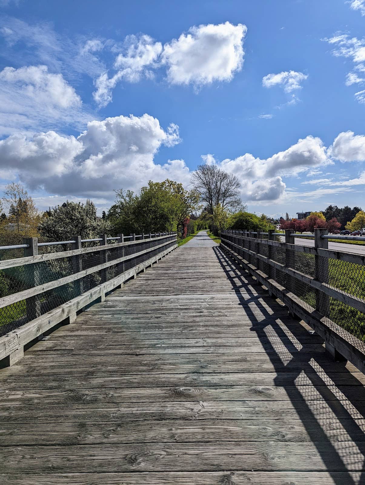
Portage Inlet Overlook
Near Victoria
Scenic viewpoints offering stunning vistas of Portage Inlet, ideal for a quick photo stop.

Victoria to Gorge Waterway
Eastern Section
A pleasant 25km round trip from downtown Victoria, showcasing urban and natural beauty.
Plans like a pro.
Thinks like you
Planning Your Visit
Trail Length & Planning
Best Use & Surface
Best Times
Insider Tips
from TikTok, Instagram & Reddit
Galloping Goose Trail Tourist Advice
🗺️ Download Trail Maps
Carry a Galloping Goose Trail map, especially for longer rides. PDF versions are handy!
🚴♀️ Bike-Friendly Path
Ideal for cycling, but also great for walking and running. Wide and clearly marked.
Galloping Goose Trail (Victoria to Sooke)
Galloping Goose Etiquette
💧 Pack Water & Snacks
Services can be sparse on longer stretches. Stay hydrated and fueled for your adventure.
🥾 Wear Comfortable Shoes
Whether walking or biking, good footwear is essential for enjoying the 55 km trail.
Galloping Goose itinerary
Tips
from all over the internet
🗺️ Download Trail Maps
Carry a Galloping Goose Trail map, especially for longer rides. PDF versions are handy!
🚴♀️ Bike-Friendly Path
Ideal for cycling, but also great for walking and running. Wide and clearly marked.
💧 Pack Water & Snacks
Services can be sparse on longer stretches. Stay hydrated and fueled for your adventure.
🥾 Wear Comfortable Shoes
Whether walking or biking, good footwear is essential for enjoying the 55 km trail.
What Travellers Say
Reviews Summary
Visitors rave about the Galloping Goose Trail's excellent maintenance and scenic beauty, stretching from Victoria to Sooke. It's praised as a top-tier cycling infrastructure, superior to many urban trails. While generally well-loved, some note that services can be sparse on longer stretches, and it's primarily geared towards cyclists.
"Amazingly well-maintained and well-serviced route from the centre of Victoria to the beautiful Sooke potholes park."
Sierra
"These pictures come from the area of the goose where it overlooks portage inlet. Its a nice, mi level ride from the downtown area to the start of the gorge (the trail marker), about 25K both ways. There are many opportunities to take a quick stop and look out over the scenery. More of a bike trail than anything so not really intended for walkers."
Graham Tranter
"Vancouver needs a Galloping Goose, and no, the Arbutus Greenway, good as it is, is not it!
Victoria's bicycle infrastructure puts Metro to shame!
Ken Sim, if you are reading this, do something, or if you are like Doug Ford, feel shame and cyclist wrath."
Peter Spencer
What People Like
What People Dislike
Frequently Asked Questions
🚇 🗺️ Getting There
You can access the Galloping Goose Trail from multiple points in Victoria. Many start near the downtown core, with easy access points along the Gorge Waterway. Parking is available at various lots along the trail, making it convenient to hop on for a portion of the route.
Yes, there are numerous parking lots specifically designated for the Galloping Goose Trail. These are strategically located along its 55 km length, offering convenient access for visitors. Check a Galloping Goose Trail map for specific parking lot locations.
While direct bus routes to every trailhead might be limited, BC Transit buses serve areas near the Galloping Goose Trail in Victoria. You can often bike or walk to an access point from a bus stop. Research specific routes based on your starting point.
The Sooke Potholes are at the western end of the Galloping Goose Trail. Many cyclists plan a trip from Victoria to Sooke Potholes, which is approximately 45 km and takes around 2.5 hours by bike.
Trail closures can occur due to maintenance or weather. It's always a good idea to check local advisories or park websites before your visit to ensure there are no unexpected closures on the Galloping Goose Trail.
🎫 🎫 Tickets & Entry
No, the Galloping Goose Trail is a public, multi-use pathway and there is no entrance fee. You can enjoy the entire 55 km length for free.
The Galloping Goose Trail is open 24 hours a day, year-round. However, it's best to use it during daylight hours for safety and to fully enjoy the scenery.
No advance booking is required to use the Galloping Goose Trail. It's a public access route, so you can simply show up and start your adventure.
If you plan to camp, such as at Sooke Potholes Campground, you will need to make reservations and pay camping fees. The trail itself does not require permits for access.
Much of the Galloping Goose Trail is paved and relatively flat, making it accessible for wheelchairs and strollers, especially the sections closer to Victoria. However, some unpaved sections might be more challenging.
🎫 🧭 Onsite Experience
The 'best part' is subjective and depends on your interests! Many love the Sooke Potholes for swimming, while others enjoy the scenic overlooks of Portage Inlet near Victoria. The entire 55 km offers diverse landscapes.
The Galloping Goose Trail is approximately 55 kilometers (about 34 miles) long, stretching from Victoria to Sooke.
Absolutely! While it's a popular bike trail, walking and running are also common activities. The wide, well-maintained path is suitable for all users.
Restroom facilities are available at various points along the trail, particularly at popular access areas and trailheads. It's wise to check a Galloping Goose Trail map for their locations.
You'll experience a variety of scenery, including woodland surrounds, coastal inlets, rivers, and open fields. The trail follows a former railway line, offering diverse views.
🍽️ 🍴 Food & Dining
Dining options are more prevalent near the Victoria end of the trail. As you venture further towards Sooke, services become less frequent. It's advisable to pack your own food and drinks for longer excursions.
Yes, particularly in Victoria and some smaller communities along the route. Areas like downtown Victoria offer numerous cafes and restaurants close to trail access points.
Sooke itself has dining options, but directly at Sooke Potholes Provincial Park, facilities are limited. It's best to plan for a picnic or eat in Sooke town before or after your visit.
Highly recommended! Packing a picnic is a great way to enjoy the scenic spots along the 55 km trail without relying on limited services.
Water fountains are available at some key access points and parks along the trail, but not consistently. Carrying your own water supply is always a safe bet.
📸 📸 Photography
Look for overlooks of Portage Inlet, the lush woodland sections, and the picturesque Sooke Potholes. The diverse scenery offers many opportunities for stunning photos.
Yes, the trail offers a variety of scenic views, from coastal inlets to dense forests, making it a great location for photography. The Sooke Potholes are particularly photogenic.
Early morning and late afternoon offer the best light for photography, with softer shadows and warmer tones. The golden hour can be magical along the inlets.
You might spot various birds and small mammals along the trail. Always maintain a safe distance and avoid disturbing wildlife for ethical photography.
The Sooke Potholes, bridges over waterways, and the trail markers themselves can make for interesting photographic subjects. The views over Portage Inlet are also popular.
For Different Travelers
Tailored advice for your travel style
👨👩👧 Families with Kids
🚴 Budget Travelers
🚶♀️ Walkers & Runners
Deep Dives
In-depth insights and expert knowledge
Exploring the Galloping Goose Trail by Bike
When cycling, consider the surface. While parts are paved, some sections are crushed gravel, so a hybrid or mountain bike is often recommended over a road bike. The Galloping Goose trail length of 55 km means you can experience diverse landscapes, from urban fringes to serene forests. Popular sections include the ride alongside Portage Inlet, offering beautiful water views, and the final approach to the natural swimming pools of Sooke Potholes.
Walking and Running the Goose
For runners, the Galloping Goose trail distances can be a great way to train. You can easily track your progress using the kilometer markers. The trail's relatively flat profile is forgiving, but be mindful of other users, especially during peak times. If you're planning a longer run, carrying water and snacks is crucial, as amenities are spread out. A Galloping Goose trail map is essential for understanding the full scope and planning your route, whether you're aiming for a short jog or a marathon-distance effort.
Navigating the Galloping Goose Trail
When considering the best part of the Galloping Goose Trail, many point to the natural beauty of the Sooke Potholes, a popular destination at the trail's western end.


Social
from TikTok, Instagram & Reddit