Mount Nakadake Kuju
Kyushu's highest peak, offering stunning volcanic landscapes, vibrant autumn colors, and a unique frozen crater lake.
Highlights
Must-see attractions

Social
From TikTok & Reddit
Best Time
Ideal hiking conditions
Mount Nakadake Kuju
Best Time
Ideal hiking conditions
Highlights
Must-see attractions
Kyushu's highest peak, offering stunning volcanic landscapes, vibrant autumn colors, and a unique frozen crater lake.
"The views from the summit are truly breathtaking, a must-see for any Kyushu adventurer!"
Check Eruption Levels
Always verify current eruption status before your hike. Access may be restricted based on volcanic activity . ⚠️
Sturdy Hiking Boots Needed
The terrain is rocky. Good grip and ankle support are essential for a safe and comfortable climb. :athletic_shoe:
Quick Facts
Rating
4.7 · 43 reviews
Type
Hiking Area
Highlights
Discover the most iconic attractions and experiences
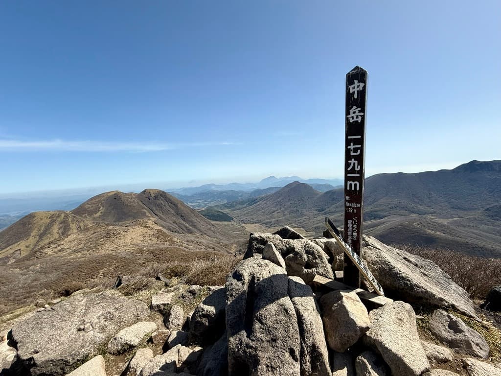
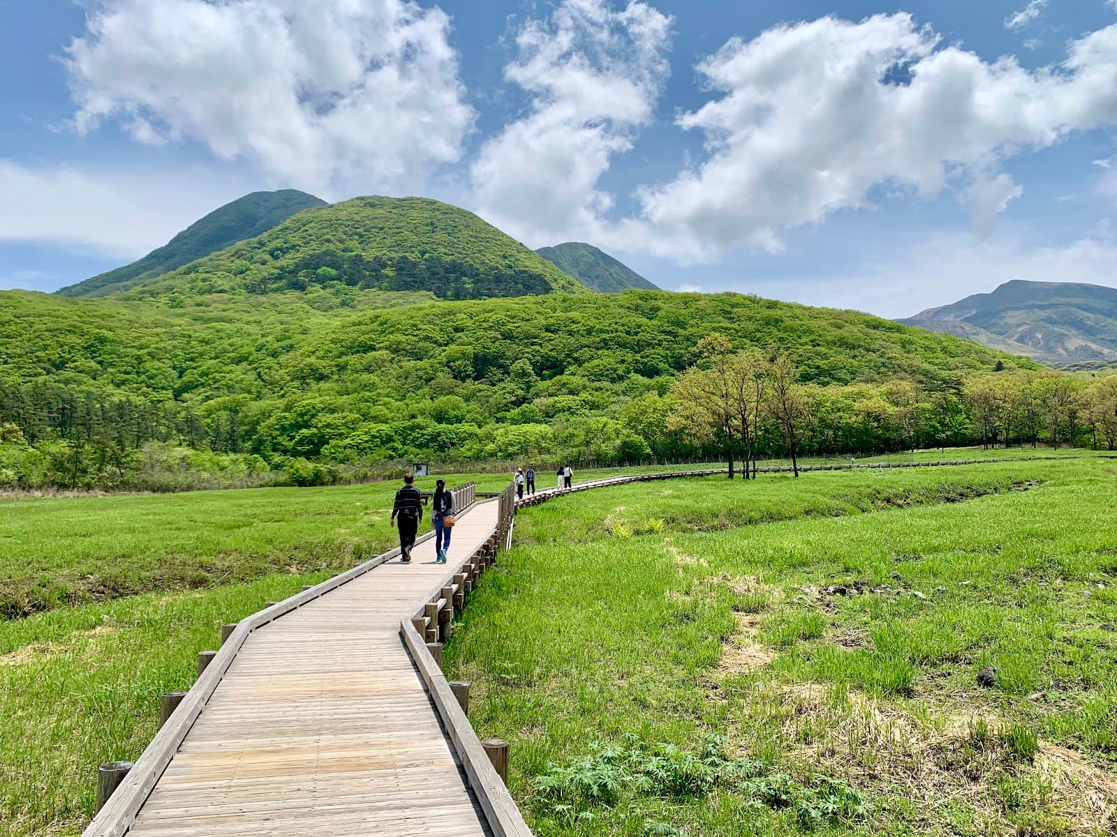
Nakadake Summit Views
Summit of Mount Nakadake
Experience breathtaking 360-degree panoramas of surrounding peaks and distant mountain ranges. A true Kyushu highlight!
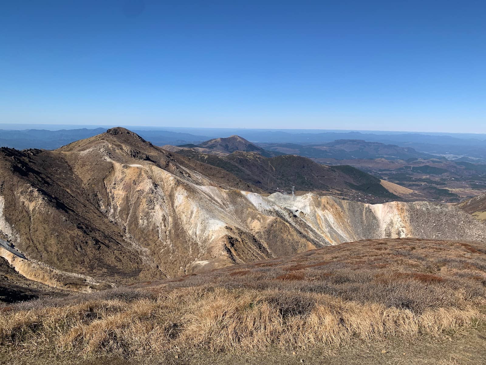
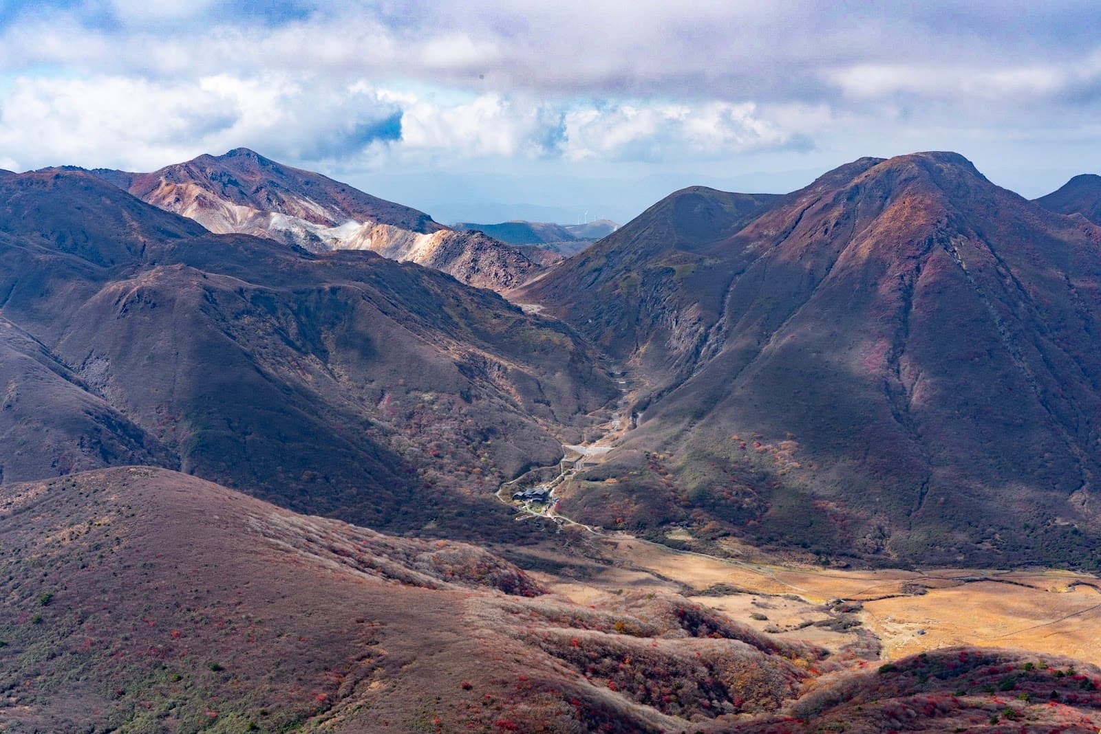
Autumn Foliage Spectacle
Kuju Mountain Range
Witness vibrant red and orange hues painting the mountainsides during the fall. A truly stunning display of nature's artistry .

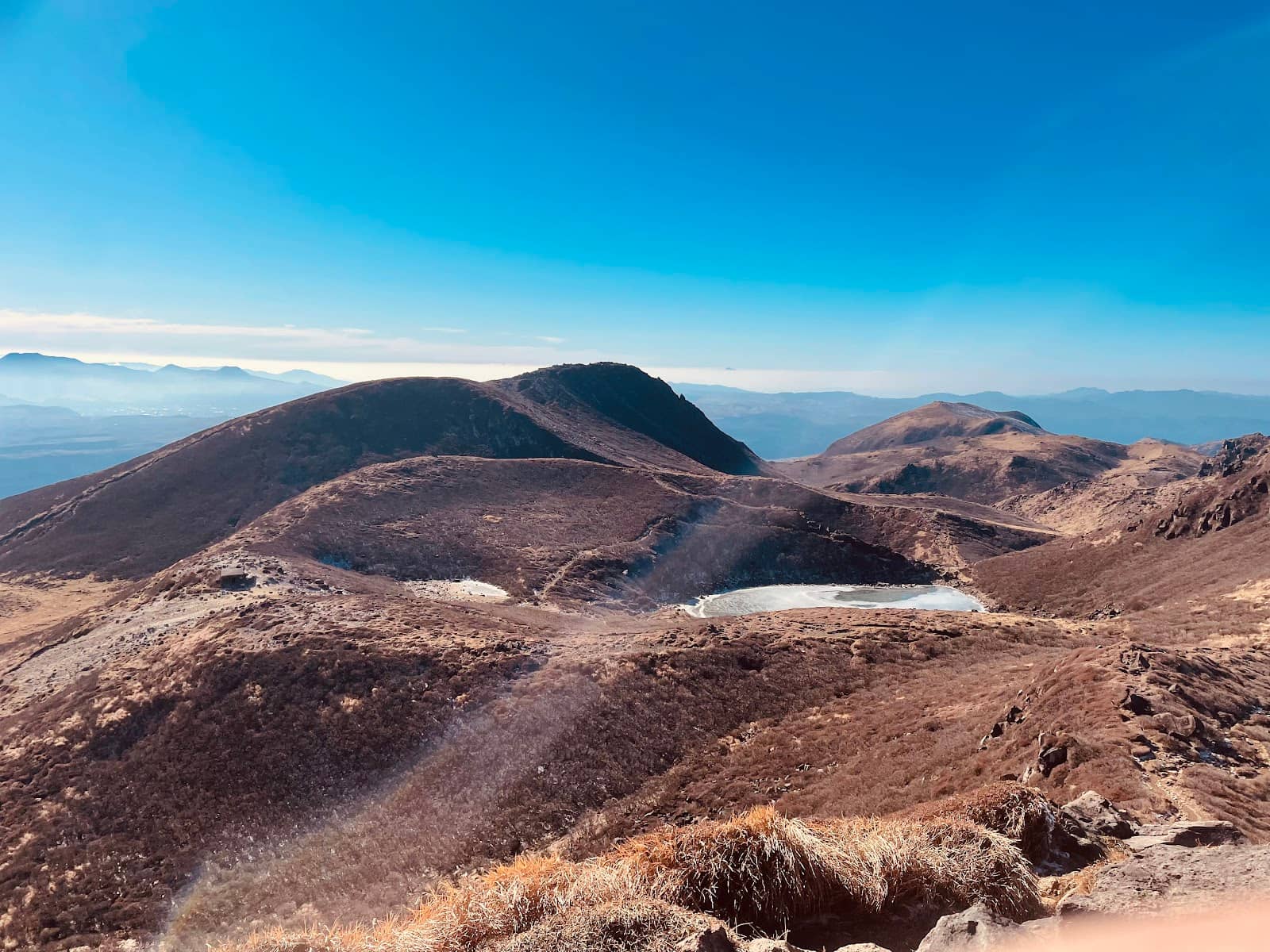
Miike Crater Lake
Below Nakadake crater
In winter, this crater lake freezes over, offering a unique opportunity to walk on ice. A rare and memorable experience .
Plans like a pro.
Thinks like you
Planning Your Visit
Timing Your Ascent
Gear Up for the Summit
Best Times
Insider Tips
from TikTok, Instagram & Reddit
Check Eruption Levels
Always verify current eruption status before your hike. Access may be restricted based on volcanic activity. ⚠️
Sturdy Hiking Boots Needed
The terrain is rocky. Good grip and ankle support are essential for a safe and comfortable climb. :athletic_shoe:
Layer Up Your Clothing
Mountain weather changes quickly. Bring layers to adjust to temperature shifts and stay comfortable. ☁️
Hydration is Key
Carry plenty of water, especially for longer hikes. Staying hydrated is crucial for endurance. :droplet:
Tips
from all over the internet
Check Eruption Levels
Always verify current eruption status before your hike. Access may be restricted based on volcanic activity. ⚠️
Sturdy Hiking Boots Needed
The terrain is rocky. Good grip and ankle support are essential for a safe and comfortable climb. :athletic_shoe:
Layer Up Your Clothing
Mountain weather changes quickly. Bring layers to adjust to temperature shifts and stay comfortable. ☁️
Hydration is Key
Carry plenty of water, especially for longer hikes. Staying hydrated is crucial for endurance. :droplet:
Consider Trail Difficulty
Routes vary. The Higashi-Senrigahama junction route has a steep rock face, while Oike is generally easier. :mountain_cableway:
What Travellers Say
Reviews Summary
Visitors consistently praise Mount Nakadake Kuju for its breathtaking panoramic views and stunning autumn foliage, calling it a highlight of Kyushu. The challenging yet rewarding hikes and the unique winter experience of the frozen crater lake are frequently mentioned positives. However, some find the mountain less characterful compared to others and note that volcanic activity can sometimes restrict access.
"The sign got all frozen, so literally I can see nothing haha, but the view is so breathtaking (25th Dec)"
Nguyễn Văn Việt
"Nakadake in the Jurenzan Mountain Range is the highest peak on Kyushu mainland and a very attractive mountain for climbers. - Elevation: 1,791m (highest peak on Kyushu mainland). Directly below is the crater lake "Miike", which freezes over in winter and allows you to walk on the ice.
I started the climb from the Akagawa trailhead."
KatoShiki
"To be honest, compared to Mt. Kuju, Mt. Ofuna and Mt. Mimata, it doesn't have much character, or anything like that.
Although it is the highest point on the Kyushu mainland."
55 51
What People Like
What People Dislike
Frequently Asked Questions
🚇 🗺️ Getting There
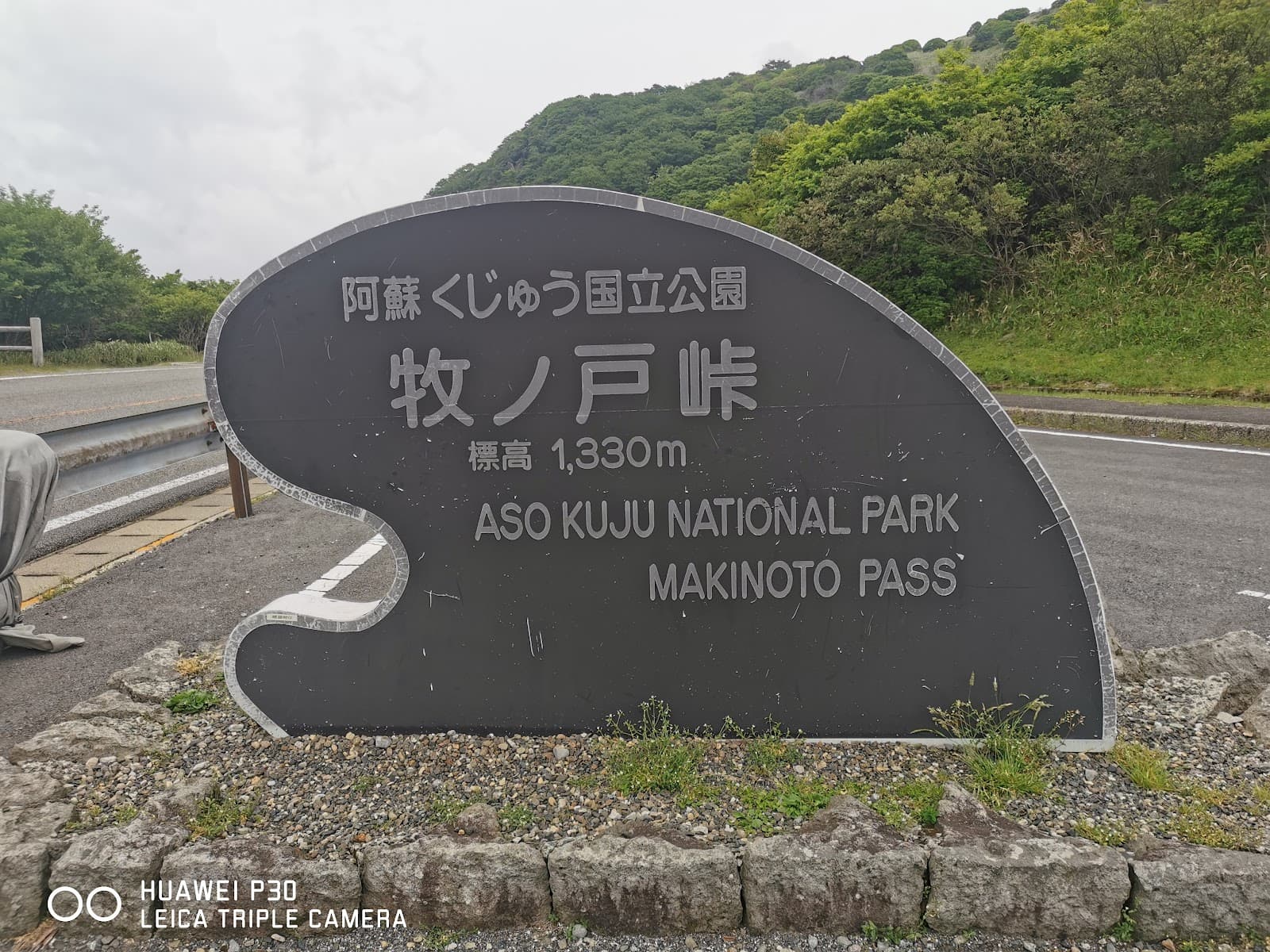
From Fukuoka, you can take a train to Oita Prefecture. Many visitors drive, with Makinoto Pass being a common starting point for hikes. Consider renting a car for flexibility. The journey can take several hours, so plan accordingly.
The Kuju Mountain Range, including Mount Nakadake, is accessible via various trailheads. Makinoto Pass is a popular access point, offering routes to Nakadake and other peaks. Research specific trailheads based on your desired hike.
While direct public transport to the summit is limited, you can reach nearby towns by train or bus from major cities like Fukuoka. From there, local buses or taxis might be available to trailheads, though options can be infrequent.
Yes, Mount Nakadake can be tackled as a day trip, especially if you're aiming for the summit and returning. However, longer traverses like the Nine Peaks Traverse are more suited for multi-day trips.
Driving is a popular option, with roads generally well-maintained. However, be prepared for winding mountain roads. Parking is available at various trailheads, but can fill up during peak seasons.
🎫 🎫 Tickets & Entry
There is no general entrance fee for Mount Nakadake Kuju National Park itself. However, some specific facilities or parking areas might have associated charges. Always check for any local fees before your visit.
Mount Nakadake is an outdoor natural attraction and is generally accessible year-round, 24 hours a day. However, hiking trails may have seasonal closures or restrictions due to weather or volcanic activity.
No, advance booking is not required for Mount Nakadake as it's a natural park. However, if you plan to stay at nearby accommodations or use specific guided tours, booking those in advance is recommended.
Yes, volcanic activity can lead to restrictions. Always check the current alert level for Mount Aso-Kuju National Park. High alert levels may close access to the summit and crater areas.
The best way to check for trail closures or access restrictions is to consult the official website for Aso-Kuju National Park or local tourism information centers. Local signage at trailheads will also indicate any current issues.
🎫 🥾 Onsite Experience
The difficulty varies greatly depending on the chosen route. The summit trail from Makinoto Pass is moderately challenging, while traverses like the Nine Peaks can be strenuous. Some sections can be steep and rocky.
Wear sturdy hiking boots with good grip. Dress in layers, as mountain weather can be unpredictable. Bring rain gear, a hat, and gloves, especially outside of summer. :athletic_shoe: ☁️
Basic facilities like restrooms are usually available at major trailheads like Makinoto Pass. However, once you're on the trails, facilities are scarce. It's best to be self-sufficient with water and snacks.
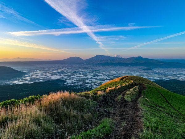
The peak autumn foliage season is typically in late October to early November. The vibrant colors transform the landscape, making it a popular time for hikers.+1
Winter hiking is possible but requires caution due to snow and ice. Trails can be slippery, and some routes may be inaccessible. The frozen Miike crater lake is a unique winter attraction.
🍽️ 🍽️ Food & Dining
Yes, there are restaurants and cafes in the surrounding Kuju and Aso areas, offering local specialties. It's advisable to pack your own food and drinks for the hike itself, as options on the mountain are very limited.
You can expect regional Japanese cuisine, often featuring fresh local ingredients. Look for dishes like ramen, udon, and local mountain vegetables. Some places might offer unique Oita specialties.
At major trailheads like Makinoto Pass, you might find small shops or vending machines selling drinks and snacks. However, it's not guaranteed, so bringing your own supplies is always the safest bet.
Yes, there are many scenic spots along the trails where you can enjoy a picnic. Find a comfortable rock or clearing with a view to refuel and take in the surroundings.
While specific recommendations vary, look for dishes that highlight local produce. In Oita, try Toriten (tempura chicken) or Bungo beef if available. Enjoying a meal with a view after a hike is highly recommended.
📸 📸 Photography
The summit offers incredible panoramic views. The autumn foliage creates stunning scenes.
Don't miss the unique frozen crater lake in winter.
Look for dramatic rock formations and sweeping vistas.
Early morning or late afternoon light provides the most dramatic and flattering light for landscape photography. Golden hour can create beautiful colors on the mountains.
A good quality smartphone camera can capture great shots. However, for landscape enthusiasts, a DSLR or mirrorless camera with a wide-angle lens will offer more versatility for capturing the expansive views.
Weather can be a challenge, with fog or rain obscuring views. The rocky terrain requires careful footing when setting up shots. Be mindful of other hikers and avoid blocking trails.
While dedicated photography tours might be rare, hiring a local guide could offer insights into the best spots and times for photography. Many visitors capture stunning images independently.


Social
from TikTok, Instagram & Reddit