Maunga Hikurangi
Sacred Ngati Porou mountain, first place on Earth to see the sunrise. A challenging hike with spiritual significance.
Highlights
Must-see attractions

Social
From TikTok & Reddit
Best Time
Best chance for sunrise views
Maunga Hikurangi
Best Time
Best chance for sunrise views
Highlights
Must-see attractions
Sacred Ngati Porou mountain, first place on Earth to see the sunrise. A challenging hike with spiritual significance.
"Best hike of my life, terrifying at times but absolutely worth the sunrise!"

🎯 Seek Iwi Permission First
Always ask permission from Ngati Porou iwi before hiking. Respect their sacred land.
👟 Sturdy Hiking Boots Essential
Trekking poles and good grip are vital, especially for the scree slope. Wear pants for bush navigation.

Quick Facts
Rating
4.8 · 22 reviews
Type
Natural Feature
Highlights
Discover the most iconic attractions and experiences
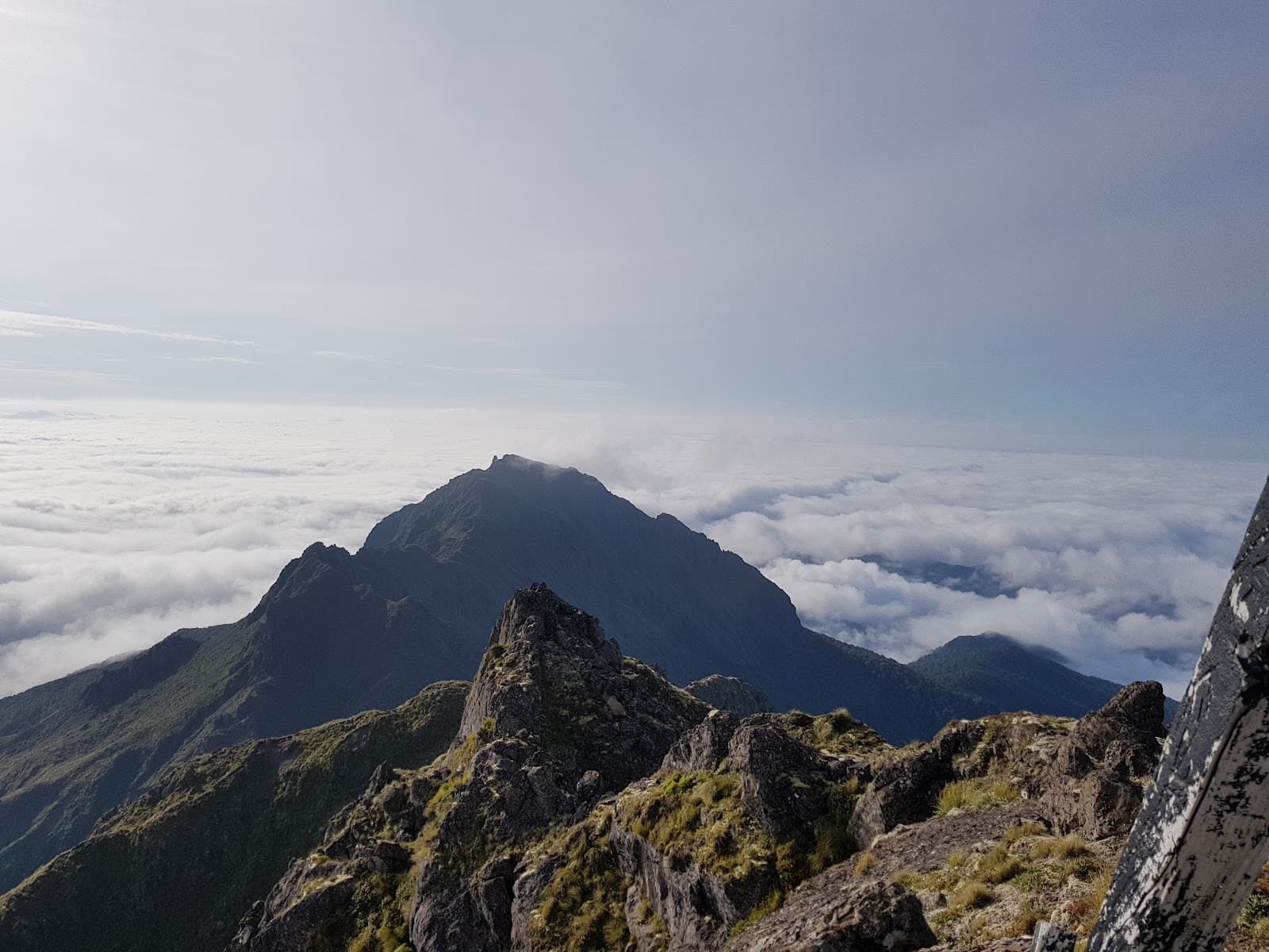
First Sunrise on Earth
Summit
Witness the world's first sunrise from this sacred peak. A truly spiritual and breathtaking experience on a clear morning.
The 'Chute' Ascent
Upper slopes
The challenging, steep scree slope near the summit. A thrilling test of endurance for experienced hikers.

Ngati Porou Cultural Significance
Throughout the mountain
Experience the deep spiritual connection of the Ngati Porou people to this sacred mountain, the tallest non-volcanic peak in NZ.
Plans like a pro.
Thinks like you
Planning Your Visit
Sunrise Summit & Sacred Ground
Weather & Trail Conditions
Best Times
Insider Tips
from TikTok, Instagram & Reddit
🎯 Seek Iwi Permission First
Always ask permission from Ngati Porou iwi before hiking. Respect their sacred land.
👟 Sturdy Hiking Boots Essential
Trekking poles and good grip are vital, especially for the scree slope. Wear pants for bush navigation.
🔦 Headlamp for Pre-Dawn Start
Essential for navigating the trail in the dark to catch the sunrise. Reflective markers are key.
💧 Be Prepared for Wet Conditions
Expect to get wet, especially if it has rained. Streams and washes can be challenging.
Tips
from all over the internet
🎯 Seek Iwi Permission First
Always ask permission from Ngati Porou iwi before hiking. Respect their sacred land.
👟 Sturdy Hiking Boots Essential
Trekking poles and good grip are vital, especially for the scree slope. Wear pants for bush navigation.
🔦 Headlamp for Pre-Dawn Start
Essential for navigating the trail in the dark to catch the sunrise. Reflective markers are key.
💧 Be Prepared for Wet Conditions
Expect to get wet, especially if it has rained. Streams and washes can be challenging.
🎒 Pack Light but Smart
Carry essentials, but heavy packs make the final ascent harder. Hut has basic amenities.
What Travellers Say
Reviews Summary
Maunga Hikurangi is lauded for its breathtaking sunrise views and profound cultural significance, offering a challenging yet incredibly rewarding hike. While the final 'chute' ascent is steep and demanding, the spiritual experience and panoramic vistas make it a bucket-list destination for many. Some visitors find the trail conditions difficult, especially in wet weather, and emphasize the importance of respecting local iwi protocols.
"We were so lucky to get so much snow! It was 10°C in Taupo so weren't sure if there would be snow on the mountain, but it food not disappoint! 0°C on the mountain and plenty of snow!"
Kimbo 82
"Mate and I spent half the night at the hut before pushing the summit at 2:30am to catch the sunrise. Safe to say it was the best hike of my life. Last unmarked scree slope was honestly terrifying at times."
Marco Tresić-Pavičić
"Incredible incredible hike - known for being one of the first places in the world to see the sunrise, it’s sacred to the Ngati Porou people, and the tallest non-volcanic summit in Aotearoa NZ.
This hike is awesome but also much more difficult than we expected. The first 90% is an easy uphill walk through farmland - say hi to sheep, cows, and pretty landscapes. Right before the hut there is a short bit gets a bit steep and hard to navigate, going by the Maui statues is easier. However this is a good test to see if you can make it to summit. This section was only difficult for us with heavy packs and rain.
The hut is a quaint small hut with some basic amenities like a drop toilet and running rainwater, some mattresses, tables, and a place to make a small fire. It usually has some extras from other backpackers so you might get lucky with some food or fuel in a pinch but don’t plan for it! Put food in the shelves overnight to keep rats out.
The climb to the summit was tough, especially in the dark. The first section is steep uphill and grassy, easy slips. Make sure to see the reflective markers before moving from the previous ones as you may lose sight of the trail in the dark. Wear pants as there is plenty of bush to push through. The next section is a short walk to a forest bit until you get up to a flatter section where you walk a long ways through streams/washes. If it is raining or has rained expect to get soaked as we did.
The last section you come up the side of the mountain, what they call the “chute”. It’s a difficult, dangerous, slippery, steep skree section with lots of loose large rocks. Whoever goes first be careful as I loosed a boulder that went straight towards my partner. Luckily she evaded. This section isn’t marked, so stay to the left as it’s much easier to get up. When you come to a fork we went left (at the almost top) but right seemed to be a much easier climb when we saw it in the light.
There are two summits, the one on the left (female) is much easier to get to as the other took some rock scrambling. Both the same height.
We did not see sunrise really, terrible conditions between heavy rains, wind, and cloud cover. Would really recommend doing this in a dry period as the trek was much more difficult in those conditions as one would expect. Alpine weather changes on a dime. Also make sure to ask permission of the farm/tribe (iwi) before heading out. We might try again in a few years on a better day :)
Kia Ora Hikurangi
I"
Mel & Erik - YouTube
What People Like
What People Dislike
Frequently Asked Questions
🚇 🗺️ Getting There
Maunga Hikurangi is located on the East Coast of the North Island of New Zealand. Access is typically via private land, so it's crucial to arrange permission and potentially a guided tour with local Ngati Porou iwi or authorized operators. The nearest major towns are Ruatoria and Hicks Bay.
Public transport directly to the trailhead is very limited. Most visitors arrange private transport or join guided tours that include transportation from nearby towns like Gisborne or Ruatoria.
The drive from Gisborne to the base of Maunga Hikurangi can take around 2-3 hours, depending on road conditions and your exact starting point. Roads can be winding and unsealed in parts.
No, the summit is only accessible by foot. The lower slopes are accessible by vehicle to a certain point, but the final ascent requires hiking.
Yes, guided tours are highly recommended, especially if you are unfamiliar with the area or the cultural protocols. They often include transport, local knowledge, and ensure you have the necessary permissions.
🎫 🎫 Tickets & Entry
There isn't a traditional ticket system. However, you absolutely must obtain permission from the local Ngati Porou iwi before visiting. Unauthorized access is disrespectful and prohibited.
Contact the Ngati Porou iwi administration or local tourism operators who work with them. They will guide you through the process and inform you of any fees or requirements.
As it's a sacred site, there are no set 'opening hours' in the traditional sense. Access is granted based on permission and respecting the land. Hiking for sunrise is common, but always confirm with iwi.
Yes, there are often access fees or guided tour costs associated with visiting Maunga Hikurangi, which contribute to the upkeep of the land and support the local community.
While technically possible with explicit permission, it is strongly advised to go with a guide who understands the cultural significance, trail conditions, and safety protocols.
🎫 🧭 Onsite Experience
The hike is considered challenging. The first 90% is a steady uphill walk, but the final 500m, known as the 'chute,' is a steep, slippery scree slope that requires careful navigation and good fitness.
A round trip can take anywhere from 6 to 10 hours, depending on your pace, fitness, and how long you spend at the summit. Many start in the early morning for sunrise.
The hut is basic, offering a drop toilet, running rainwater, mattresses, tables, and a fireplace. It's a shelter, not a luxury lodge. Pack all your food and be prepared for minimal amenities.
Wear sturdy hiking boots with good grip, waterproof and windproof outer layers, and long pants to protect against bush. Layers are essential due to changing alpine conditions.
The lower sections are generally clear, but the final ascent ('chute') is unmarked and can be difficult to navigate, especially in the dark or poor weather. Pay close attention to reflective markers.
📸 📸 Photography
Sunrise is the most iconic time, offering dramatic light. Golden hour before sunset can also be beautiful, and the expansive views are great for landscape photography throughout the day.
A wide-angle lens is great for capturing the vast landscapes and sunrise. A sturdy tripod is useful for low-light conditions. Consider a polarizing filter to enhance skies and reduce glare.
The summit itself offers panoramic views. The Maui statues along the trail provide unique cultural photo opportunities. The changing terrain offers diverse photographic subjects.
Weather is the biggest challenge – fog, rain, and wind can obscure views and make shooting difficult. The unmarked final ascent also requires focus on safety over photography.
Drone usage may be restricted due to the sacred nature of the mountain and potential iwi regulations. Always check with Ngati Porou iwi for any drone policies before flying.


Social
from TikTok, Instagram & Reddit