Halsema Highway Highest Point Atok Benguet
Experience the Philippines' highest highway point at 7,400 ft, offering breathtaking mountain vistas and a refreshing, cool climate.
Highlights
Must-see attractions

Social
From TikTok & Reddit
Best Time
Secure parking & enjoy views
Halsema Highway Highest Point Atok Benguet
Best Time
Secure parking & enjoy views
Highlights
Must-see attractions
Experience the Philippines' highest highway point at 7,400 ft, offering breathtaking mountain vistas and a refreshing, cool climate.
"Super cool experience visiting the highest point of the Philippine highway system! The view is absolutely stunning."

🧥 Pack for the Cold
It's chilly at 7,400 ft! Bring layers, a jacket, and maybe even gloves. ☁️
👟 Wear Comfy Shoes
You'll want comfortable footwear for exploring the viewpoints and shops. :athletic_shoe:

Quick Facts
Rating
4.6 · 1,151 reviews
Type
Tourist Attraction
Highlights
Discover the most iconic attractions and experiences
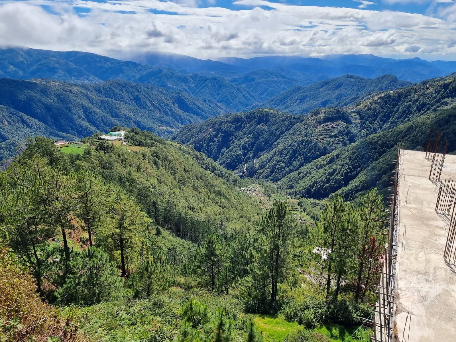
The Summit View
Highest Point
Experience breathtaking panoramic views of the Cordillera mountains and a refreshing, cool breeze.
Historic Half Tunnel
Halsema Highway
Marvel at the engineering feat of the historical half tunnel carved into the mountainside.

Charming Sari-Sari Store
Near Highest Point
Stop by a picturesque sari-sari store for a warm drink and local snacks amidst stunning scenery.
Plans like a pro.
Thinks like you
Planning Your Visit
Embrace the Altitude
Timing Your Scenic Stop
Best Times
Insider Tips
from TikTok, Instagram & Reddit
🧥 Pack for the Cold
It's chilly at 7,400 ft! Bring layers, a jacket, and maybe even gloves. ☁️
👟 Wear Comfy Shoes
You'll want comfortable footwear for exploring the viewpoints and shops. :athletic_shoe:
📸 Photo Ops Galore
The views are incredible! Don't forget your camera or phone for stunning mountain shots. :camerawithflash:
🛍️ Souvenir Shopping
Browse local crafts and souvenirs available at stalls near the highest point. 🎁
Tips
from all over the internet
🧥 Pack for the Cold
It's chilly at 7,400 ft! Bring layers, a jacket, and maybe even gloves. ☁️
👟 Wear Comfy Shoes
You'll want comfortable footwear for exploring the viewpoints and shops. :athletic_shoe:
📸 Photo Ops Galore
The views are incredible! Don't forget your camera or phone for stunning mountain shots. :camerawithflash:
🛍️ Souvenir Shopping
Browse local crafts and souvenirs available at stalls near the highest point. 🎁
☕ Grab a Warm Drink
Enjoy a hot cup of coffee or taho from local vendors to warm up. ☕
What Travellers Say
Reviews Summary
Visitors rave about the breathtaking mountain views and the invigoratingly cool climate at the Highest Point of Halsema Highway. It's a highly recommended scenic stop for road trips, offering a refreshing break with opportunities to buy local souvenirs and enjoy warm treats. While generally accessible, some note potential fees and the need for caution on the winding highway.
"🌲 Highest Point in Atok, Benguet — standing tall at 7,400 ft above sea level! 🏔️ A scenic stop along Halsema Highway with breathtaking mountain views, cool breeze, and perfect photo spots. 📸✨
🅿️ Parking available along the roadside
💰 No entrance fee
📍 A must-visit for road trips to Baguio or Sagada! 🚗"
Sarah
"The Former Highest Point in Atok, Benguet remains a significant landmark along Halsema Highway despite being surpassed by a newly identified higher elevation. It offers visitors panoramic views of the Cordillera mountains and surrounding landscapes, showcasing the natural beauty of Benguet. Beyond its historical significance, the site continues to attract travelers as a scenic stop that highlights the region’s unique geography and cool climate."
Anthony Santos
"Super cool experience visiting the highest point of the Philippine highway system! The view is absolutely stunning—mountains, clouds, and that fresh, cool air. It’s a nice stop if you’re on a road trip around Benguet. Great spot for photos and just soaking in the scenery. Worth checking out if you’re in the area!"
Lyndy Baradero
What People Like
What People Dislike
Frequently Asked Questions
🚇 🗺️ Getting There
The Highest Point is located along the Halsema Highway in Atok, Benguet. It's a popular stop for road trips heading to or from Baguio and Sagada. Most visitors arrive by private car or motorcycle. Public transportation options might be limited, so consider joining a tour or renting a vehicle.
Halsema Highway is known for its winding roads and steep drops, so drive cautiously and be aware of your surroundings. It's advisable to drive during daylight hours and check weather conditions beforehand, especially during the rainy season.
The Halsema Highway Highest Point stands at an impressive 7,400 feet (approximately 2,255 meters) above sea level. +1
Besides the Highest Point itself, keep an eye out for the historical half tunnel, which is another notable landmark along the highway. You might also spot unique sari-sari stores and farms along the route.
The travel time from Baguio City to the Highest Point on Halsema Highway can vary significantly depending on traffic and road conditions, but it typically takes around 1.5 to 2 hours.
🎫 🎫 Tickets & Entry
There is no direct entrance fee to access the viewpoint at the Highest Point. However, some sources mention a potential environmental fee of 100 PHP and an additional 100 PHP per person for entry to specific areas at the top. It's always good to have some cash on hand.
The Highest Point is an outdoor scenic viewpoint along the highway, so it's generally accessible at any time. However, for the best experience and safety, visiting during daylight hours is recommended.
Since there isn't a formal ticketing system or entrance fee in the traditional sense, advance booking is not required or possible for the Highest Point itself.
Parking is typically available along the roadside near the Highest Point. While there isn't a designated paid parking lot, be mindful of where you park to avoid obstructing traffic.
The 'Former Highest Point' refers to a previously recognized highest elevation on the highway. While a new higher point has been identified, the former site remains a significant landmark and popular stop for its views and historical context.
🎫 🏞️ Onsite Experience
At the Highest Point, you can enjoy breathtaking mountain views, take photos, buy souvenirs, and savor local snacks like taho. It's a perfect spot to relax and soak in the cool, crisp air.
The walk to the highest point is generally described as easy, but it might not be ideal for individuals with significant mobility issues due to uneven terrain. Assess the path upon arrival.
Restroom facilities are not explicitly mentioned in most traveler accounts. It's advisable to use facilities before reaching the viewpoint or inquire locally.
You can find various local crafts, trinkets, and possibly woven goods at the souvenir stalls located near the Highest Point.
Absolutely! The Highest Point is a prime location for photography, offering stunning vistas of the surrounding mountains and valleys.
🍽️ ☕ Food & Dining
Yes, there are small sari-sari stores and vendors selling snacks like taho (with ube and strawberry flavors) and coffee. These offer a chance to warm up and experience local flavors.
Taho, a warm soy pudding, is a popular treat, especially with unique flavors like ube (purple yam) and strawberry. Hot coffee is also a great option to combat the cold.
Bringing your own snacks and drinks is generally acceptable. However, remember to dispose of your trash properly to help keep the area clean.
The Highest Point is a scenic stop along a highway, so fine dining options are unlikely. The focus is on local snacks and quick bites from vendors.
Prices are generally affordable, reflecting local market rates for snacks and beverages. Expect to pay around 30-50 PHP for items like taho or coffee.
📸 📸 Photography
Early morning or late afternoon can offer beautiful lighting for landscape photography. However, the dramatic cloud formations and mountain vistas are captivating throughout the day.
You can capture sweeping panoramic views of the Cordillera mountain range, dramatic cloudscapes, and the winding Halsema Highway itself. +1
The main viewpoint offers the most expansive vistas. The historical half tunnel also provides a unique architectural element for photos. Don't forget to capture the charming sari-sari store for a touch of local life.
A wide-angle lens is great for capturing the vast landscapes. A telephoto lens can be useful for isolating mountain peaks. However, a smartphone camera is more than sufficient for most visitors. :iphone:
Focus on capturing mist or fog if present, the bundled-up attire of people, and the vast, open mountain scenery that evokes a sense of coolness.


Social
from TikTok, Instagram & Reddit