Dent de Broc
A challenging mountain hike in Gruyère offering breathtaking panoramic views, with an exposed summit trail for the adventurous.

Highlights
Must-see attractions

Social
From TikTok & Reddit
Best Time
Golden hour views
Dent de Broc
Best Time
Golden hour views
Highlights
Must-see attractions
A challenging mountain hike in Gruyère offering breathtaking panoramic views, with an exposed summit trail for the adventurous.
"10/10 views!! 100% worth the tough hike up!"

👟 Sturdy Hiking Boots Essential
Don't underestimate the trail! Proper hiking boots with good grip are crucial for the exposed final ascent.
🌅 Aim for Sunset Views
The panoramic views are spectacular at sunset. Plan your hike to reach the summit around this time.

Quick Facts
Rating
4.9 · 34 reviews
Type
Natural Feature
Highlights
Discover the most iconic attractions and experiences
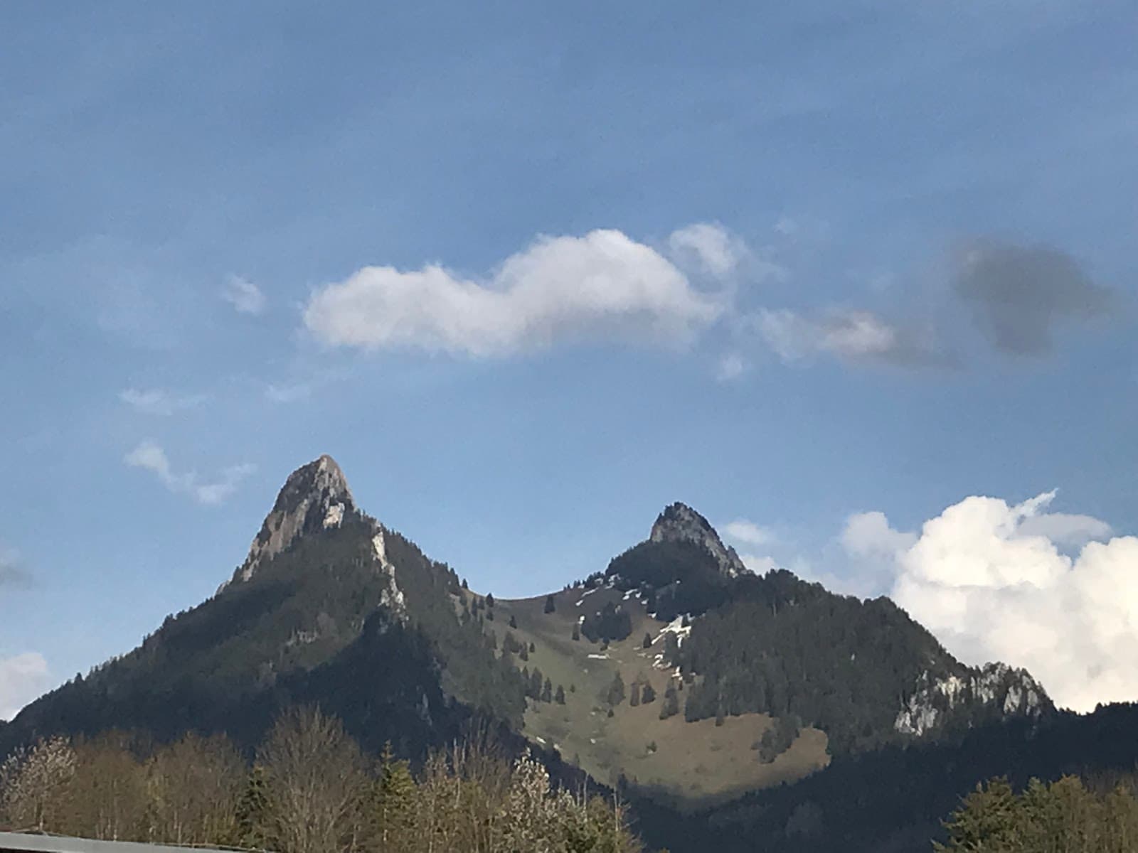
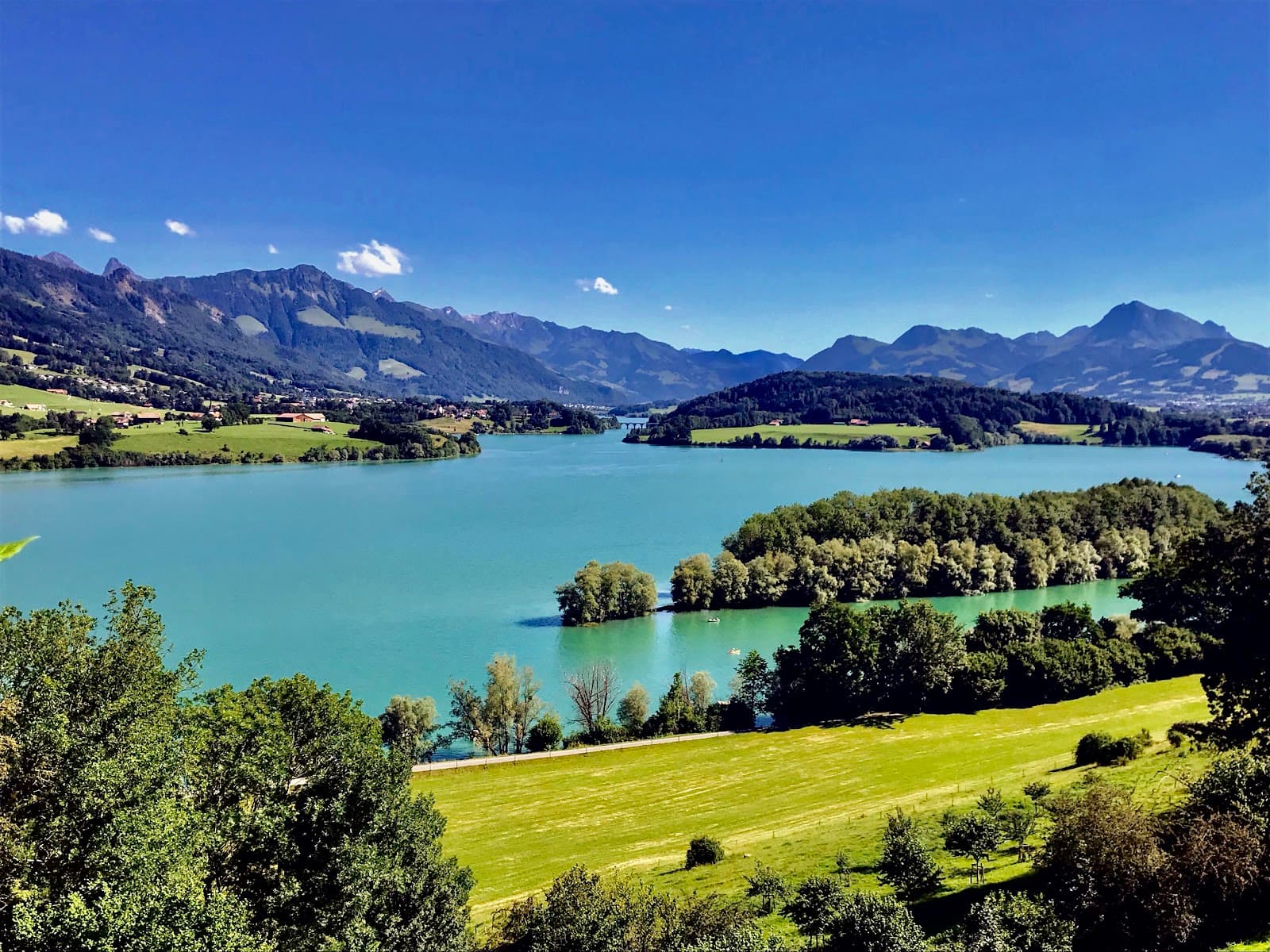
The Summit Panorama
Dent de Broc Summit
Breathtaking 360-degree views of the Gruyère region and beyond. A truly unforgettable vista.
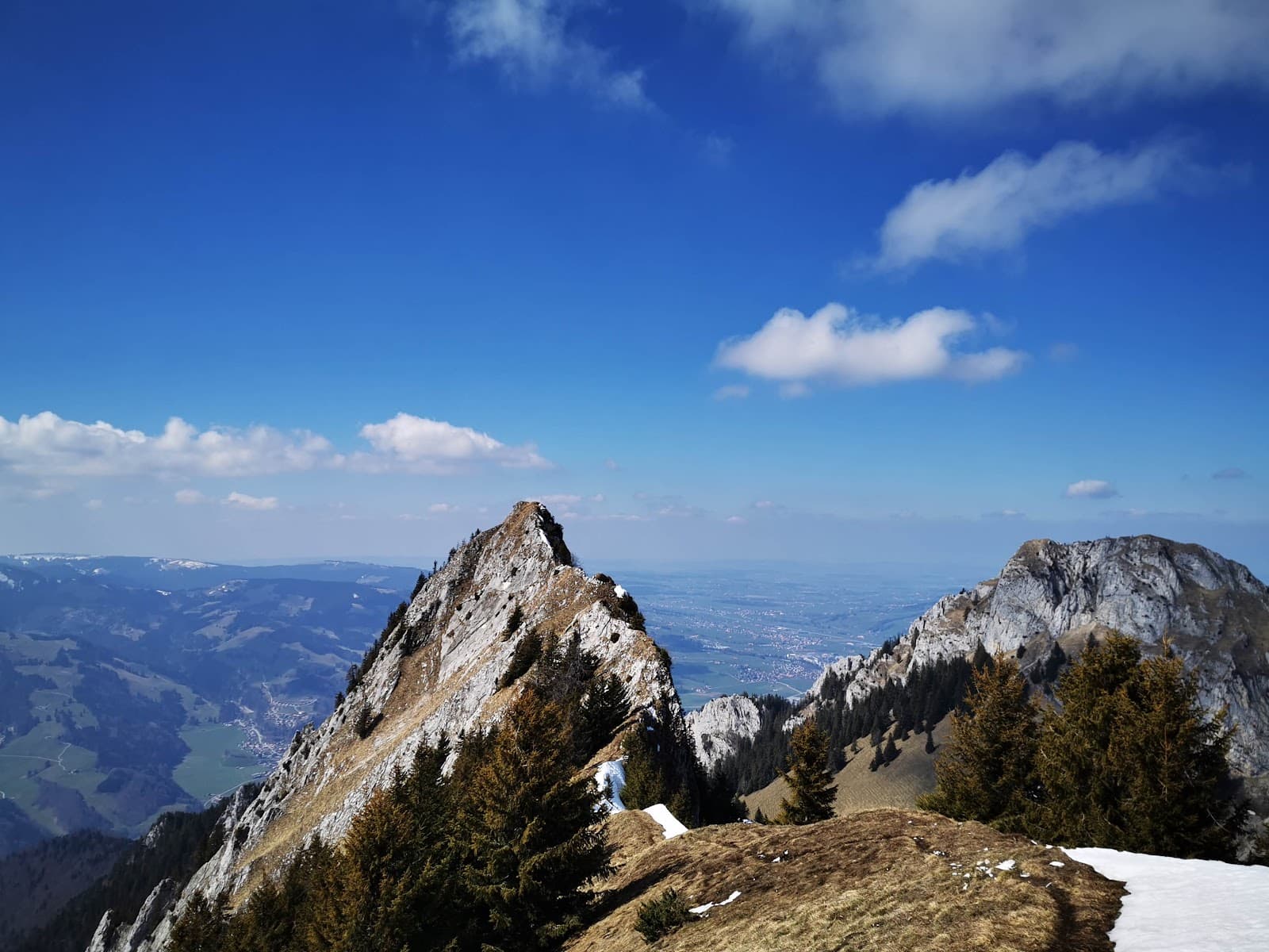
The Exposed Final Ascent
Upper slopes of Dent de Broc
A thrilling, narrow trail requiring sure footing and a head for heights. An adventure in itself!

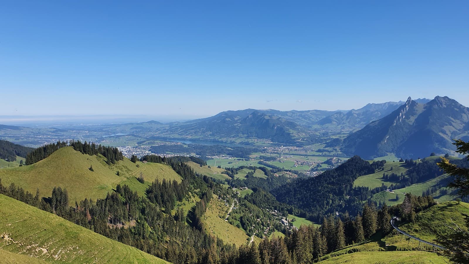
Forest-Covered Lower Trails
Lower slopes of Dent de Broc
A more comfortable, forested path offering a sense of security before the more challenging sections.
Plans like a pro.
Thinks like you
Planning Your Visit
Prepare for an Exposed Summit
Timing is Key for Views
Best Times
Insider Tips
from TikTok, Instagram & Reddit
👟 Sturdy Hiking Boots Essential
Don't underestimate the trail! Proper hiking boots with good grip are crucial for the exposed final ascent.
🌅 Aim for Sunset Views
The panoramic views are spectacular at sunset. Plan your hike to reach the summit around this time.
⚠️ Respect the 'Blue Trail'
The final section is a T4 trail. If you have vertigo or are inexperienced, consider stopping at the sub-summit.
💧 Bring Plenty of Water
It's a challenging hike, so stay hydrated throughout your ascent and descent.
Tips
from all over the internet
👟 Sturdy Hiking Boots Essential
Don't underestimate the trail! Proper hiking boots with good grip are crucial for the exposed final ascent.
🌅 Aim for Sunset Views
The panoramic views are spectacular at sunset. Plan your hike to reach the summit around this time.
⚠️ Respect the 'Blue Trail'
The final section is a T4 trail. If you have vertigo or are inexperienced, consider stopping at the sub-summit.
💧 Bring Plenty of Water
It's a challenging hike, so stay hydrated throughout your ascent and descent.
🔦 Headlamp for Descent
If you're hiking for sunset, a headlamp is essential for a safe descent after dark.
What Travellers Say
Reviews Summary
Visitors consistently praise the absolutely breathtaking views from Dent de Broc, calling the summit panorama 10/10 and 100% worth the effort. However, many highlight the challenging and exposed nature of the final ascent, emphasizing the need for proper footwear and a lack of vertigo. Some find the hike tougher than expected, with the 'blue trail' being a significant hurdle for less experienced hikers.
"10/10 views!! 100% worth the tough hike up! It says it takes 3h but it was realistically 4-5! The last bit to the summit is a blue trail meaning it’s only for experienced climbers but you don’t need specialist equipment!"
Ross H
"An amazing view on the country"
Julien Dessinet
"Breathtaking overview of a good part of French-speaking Switzerland, I recommend it. But the route requires firm footing and a lack (or almost no) of vertigo, because during my descent I unfortunately encountered too many visibly inexperienced people in simple city sneakers (smooth soles) climbing as if it were the coolest spot in the area. In the mountains, accidents can happen very quickly, so always be careful and equipped."
Kevin Angeloni
What People Like
What People Dislike
Frequently Asked Questions
🚇 🗺️ Getting There
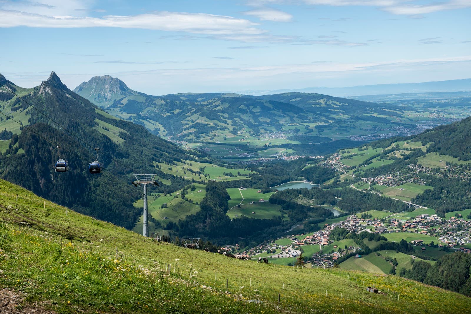
The most common starting point is near Broc. Look for parking before the Pinte du Pralet, where you'll find hiking signs for Dent de Broc. Some suggest parking near Gruyère for a longer route.
While specific public transport routes to the immediate trailhead might be limited, you can likely reach the general area of Broc or Gruyère by train and then bus, followed by a walk to the starting point. Check Swiss public transport schedules for the most up-to-date information.
Driving is a popular option. Navigate towards Broc and look for designated parking areas near the start of the hiking trails.
Roads leading to the parking areas are generally well-maintained. However, always check local road conditions, especially during winter or after heavy rain.
Yes, Dent de Broc is a popular day trip from Fribourg. It's approximately a 30-40 minute drive to the trailhead.
🎫 🎫 Tickets & Entry
No, hiking Dent de Broc is free. There are no entrance fees to access the trails or the summit.
The trails are open year-round, 24 hours a day. However, the best times to visit are during daylight hours for safety and enjoyment.
Spring, summer, and early autumn offer the most pleasant hiking conditions. Winter can bring snow and ice, making the trails more challenging and potentially dangerous.
No booking is required for hiking Dent de Broc. It's a natural attraction accessible to all.
No permits are required for general hiking on Dent de Broc. Enjoy the natural beauty responsibly.
🎫 🧭 Onsite Experience
The hike is generally considered challenging. While lower sections are moderate, the final ascent is a T4 'blue trail' with exposed sections and requires good fitness and a head for heights.
Most sources estimate around 4 to 5 hours for the round trip, though some may complete it in 3.5 hours. This includes time for breaks and enjoying the views. +1
Expect breathtaking panoramic views of the Gruyère region, including Lake Gruyère, the surrounding mountains, and French-speaking Switzerland.
The final summit trail is not recommended for beginners or those with vertigo due to its exposed nature and steep, narrow path.
There are typically no facilities like restrooms or shops directly at the trailhead or summit. It's advisable to come prepared with all your necessities.
📸 📸 Photography
The summit offers unparalleled panoramic shots. The exposed trail itself also provides dramatic photo opportunities, capturing the scale and thrill of the hike. +1
Late afternoon and sunset are ideal for photography, offering beautiful golden hour light and dramatic shadows.
A wide-angle lens is great for capturing the expansive panoramas. A sturdy tripod can be helpful for low-light conditions during sunset.
Yes, always prioritize safety. Be mindful of your footing and the exposed edges when taking photos, especially on the summit trail.
Drone regulations can vary. It's best to check local rules and regulations regarding drone usage in natural parks and mountainous areas before flying.


Social
from TikTok, Instagram & Reddit