
Ozaukee Interurban Trail
A scenic 30-mile paved trail through Ozaukee County, connecting charming towns and offering beautiful natural vistas.

Highlights
Must-see attractions

Social
From TikTok & Reddit
Best Time
Fewer crowds, peaceful rides
Ozaukee Interurban Trail
Best Time
Fewer crowds, peaceful rides
Highlights
Must-see attractions
A scenic 30-mile paved trail through Ozaukee County, connecting charming towns and offering beautiful natural vistas.

💧 Carry Plenty of Water
Long rides require significant water. Plan refills or bring a large supply as stops are infrequent.
🗺️ Download Trail Map
While the trail is well-marked, having an offline map is handy for navigation and finding amenities.

Quick Facts
Highlights
Discover the most iconic attractions and experiences
Scenic Lake Michigan Views
Eastern sections of the trail
Enjoy breathtaking vistas of Lake Michigan as you pedal or stroll along the eastern parts of the trail.

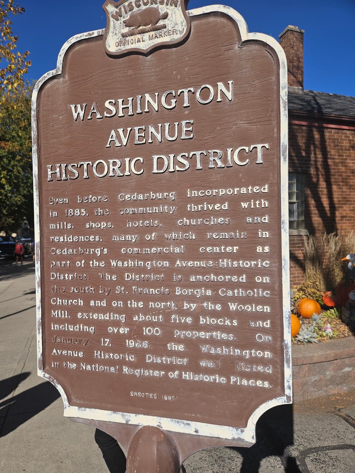
Historic Downtown Cedarburg
Cedarburg
Take a break in charming Cedarburg, with its unique shops, historic buildings, and local eateries.

Wildlife Spotting
Various points along the trail
Keep an eye out for diverse local wildlife, from birds to small mammals, in the natural surroundings.
Plans like a pro.
Thinks like you
Planning Your Visit
Hydration is Key
Trail Etiquette & Safety
Best Times
Insider Tips
from TikTok, Instagram & Reddit
Water availability along the Ozaukee Interurban?
I’m planning a long ride to cap off the summer from Tosa to the northern end of the Interurban, a bit over 80 miles. It’ll be my first time on the Interurban. A small top tube bag and jersey pockets will be enough for nutrition, but there’s no way I’ll be able to carry enough…
💧 Carry Plenty of Water
Long rides require significant water. Plan refills or bring a large supply as stops are infrequent.
🗺️ Download Trail Map
While the trail is well-marked, having an offline map is handy for navigation and finding amenities.
Weekend biking trip suggestions?
My wife and I are looking to get out of Chicago for a few days and stay somewhere within a reasonable driving distance. We want to bring our bikes and spend time exploring some great cycle routes / trips. Looking for suggestions on places to visit. Thanks in advance!
Best bike trails in Wisconsin?
Recently got a bike rack - looking for bike trail recommendations in Wisconsin!
👟 Wear Comfortable Shoes
Whether biking or walking, comfortable footwear is essential for enjoying the trail's length.
🚲 Bike Rentals Available
Several towns along the trail offer bike rentals if you don't have your own.
Planning to Move to Milwaukee Area
My family are looking to move back to Wisconsin from Denver and are looking at the Milwaukee area. My wife and I are pretty big cyclists. Here in Denver we are fortunate to have great paths and safe roads. My wife primarily enjoys paths while like both a path and road. We are…
Tips
from all over the internet
💧 Carry Plenty of Water
Long rides require significant water. Plan refills or bring a large supply as stops are infrequent.
🗺️ Download Trail Map
While the trail is well-marked, having an offline map is handy for navigation and finding amenities.
👟 Wear Comfortable Shoes
Whether biking or walking, comfortable footwear is essential for enjoying the trail's length.
🚲 Bike Rentals Available
Several towns along the trail offer bike rentals if you don't have your own.
What Travellers Say
Reviews Summary
Visitors rave about the Ozaukee Interurban Trail's well-maintained paved surface, making it perfect for cycling, walking, and family outings. The trail's scenic beauty, especially the Lake Michigan views, and the charm of towns like Cedarburg are frequently highlighted as major draws. Some users note that water stops can be infrequent on longer stretches, requiring careful planning for hydration.
What People Like
What People Dislike
Frequently Asked Questions
🚇 🗺️ Getting There
The Ozaukee Interurban Trail is accessible from numerous points across Ozaukee County, Wisconsin. Major access points include parks and downtown areas in Grafton, Cedarburg, Port Washington, and Belgium. Parking is generally available at these access points.
Public transportation options directly to trailheads are limited. It's best to drive to a specific access point. Consider carpooling if you're traveling with a group.
The trail is well-marked with signage. For detailed navigation, especially for longer rides, it's highly recommended to use a trail map. Many users find offline map apps on their phones very helpful.
Yes, you can connect to the Ozaukee Interurban Trail from the Milwaukee area. The Hank Aaron State Trail and Oak Leaf Trail can lead you north towards the Interurban, though it involves some on-road cycling.
Yes, numerous parking areas are available at trailheads and in adjacent parks and downtown areas. These are convenient for day-trippers and those starting longer journeys.
🎫 🎫 Tickets & Entry
No, the Ozaukee Interurban Trail is a public recreational path and does not require any tickets or admission fees for use. It's free for everyone to enjoy.
The trail is generally open from dawn to dusk. However, specific park access points might have their own hours, so it's wise to check local park regulations if you plan to visit very early or late.
The trail is beautiful year-round, but late spring through early fall offers the most pleasant weather for cycling and walking. Autumn foliage is particularly stunning.
For organized group events or races, you may need to obtain permits from the Ozaukee County Parks Department. It's best to contact them in advance to inquire about requirements.
While the trail itself is not officially lit for night use, some sections near town centers might have streetlights. However, for safety reasons, it's recommended to use the trail during daylight hours.
🎫 🧭 Onsite Experience
The majority of the Ozaukee Interurban Trail is paved asphalt, making it ideal for road bikes, rollerblades, and strollers. Some sections might have gravel or crushed stone.
The Ozaukee Interurban Trail spans approximately 30 miles, running from Grafton in the south to Belgium in the north.
Restrooms and water fountains are available at various parks and designated rest stops along the trail, particularly in larger towns like Cedarburg and Port Washington. However, they are not continuous, so plan accordingly.
Yes, the paved surface and relatively flat terrain make it very family-friendly. Many families enjoy shorter rides or walks on sections of the trail.
Towns like Cedarburg and Port Washington offer charming downtown areas with shops, restaurants, cafes, and historical sites, providing great opportunities for breaks and exploration.
🍽️ 🍽️ Food & Dining
You'll find numerous dining options in the towns along the trail, including Cedarburg, Grafton, and Port Washington. These towns offer everything from casual cafes to sit-down restaurants.
Directly on the trail, options are limited to picnic areas. However, many restaurants and cafes are just a short walk or bike ride from trail access points in the towns.
Absolutely! There are many scenic spots and designated picnic areas along the Ozaukee Interurban Trail perfect for enjoying a packed lunch.
Locals often recommend exploring the historic downtown Cedarburg for its bakeries and cafes, and Port Washington for its waterfront dining options.
Yes, convenience stores and grocery stores are available in the towns adjacent to the trail, making it easy to stock up on snacks and beverages.
📸 📸 Photography
Look for scenic overlooks of Lake Michigan, charming bridges, historic downtowns like Cedarburg, and the natural landscapes along the trail. The changing seasons also offer unique photographic opportunities.
It can be challenging to take photos while actively cycling. It's best to stop at designated rest areas or scenic points to safely capture your shots.
The 'golden hours' – shortly after sunrise and before sunset – offer the most beautiful, soft light for photography. Midday can be harsh, but good for capturing details.
The historic Cedar Creek Settlement in Cedarburg, the picturesque harbor in Port Washington, and any of the numerous bridges crossing creeks are excellent photo opportunities.
Drone usage regulations can vary by park and municipality. Always check local ordinances and obtain necessary permissions before flying a drone near the trail or in public parks.


Social
from TikTok, Instagram & Reddit