Iron Mountain Road
A legendary scenic byway in South Dakota's Black Hills, famed for its pigtail bridges and tunnels framing Mount Rushmore.
Highlights
Must-see attractions

Social
From TikTok & Reddit
Best Time
Fewer crowds, stunning colors
Iron Mountain Road
Best Time
Fewer crowds, stunning colors
Highlights
Must-see attractions
A legendary scenic byway in South Dakota's Black Hills, famed for its pigtail bridges and tunnels framing Mount Rushmore.
Drive Slowly & Safely
Embrace the journey! Take your time on the winding roads and through the tunnels. :oncoming_automobile:
RV & Trailer Caution
Be mindful of tight turns and tunnel clearances. Larger vehicles may struggle. :truck:
Quick Facts
Address
Highlights
Discover the most iconic attractions and experiences
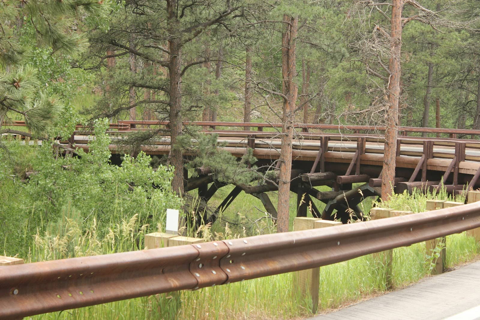
Pigtail Bridges
Various points along the road
Iconic, gravity-defying bridges that loop over themselves for elevation gain. A true engineering marvel!
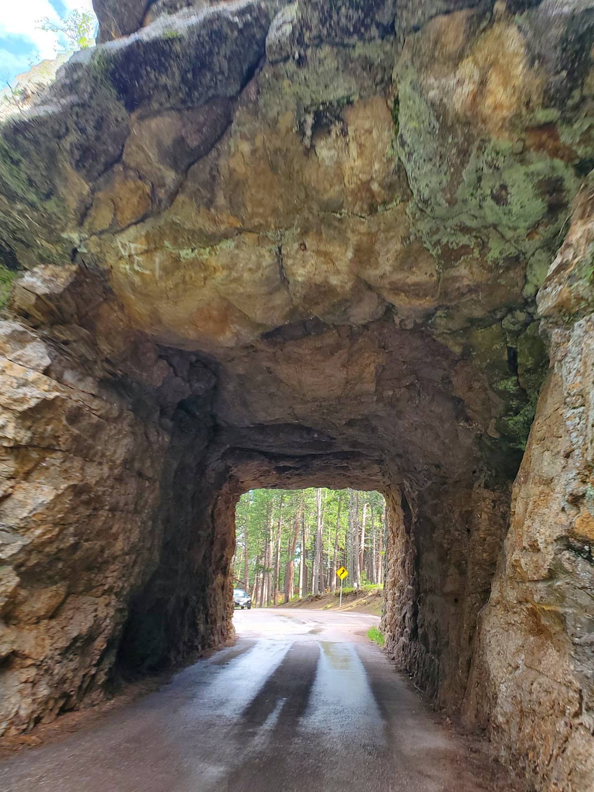
Through-the-Mountain Tunnels
Multiple tunnels
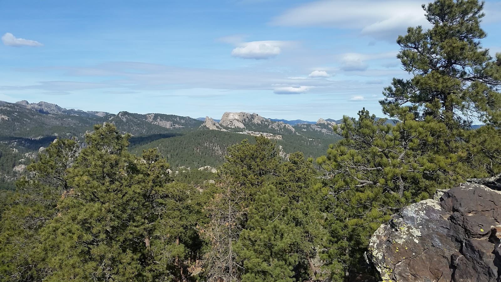
Drive through granite tunnels with strategically placed 'windows' offering framed views of Mount Rushmore.

Panoramic Vistas
Numerous pull-offs
Breathtaking overlooks provide sweeping views of the Black Hills and iconic presidential monuments.
Plans like a pro.
Thinks like you
Planning Your Visit
Timing is Everything
Prepare for the Journey
Best Times
Insider Tips
from TikTok, Instagram & Reddit
Drive Slowly & Safely
Embrace the journey! Take your time on the winding roads and through the tunnels. :oncoming_automobile:
RV & Trailer Caution
Be mindful of tight turns and tunnel clearances. Larger vehicles may struggle. :truck:
Capture the Views
Stop at pull-offs for incredible photo ops. The tunnels offer unique framed shots! :camerawithflash:
Check Road Status
Conditions can change, especially in shoulder seasons. Always check before you go. 💁
Tips
from all over the internet
Drive Slowly & Safely
Embrace the journey! Take your time on the winding roads and through the tunnels. :oncoming_automobile:
RV & Trailer Caution
Be mindful of tight turns and tunnel clearances. Larger vehicles may struggle. :truck:
Capture the Views
Stop at pull-offs for incredible photo ops. The tunnels offer unique framed shots! :camerawithflash:
Check Road Status
Conditions can change, especially in shoulder seasons. Always check before you go. 💁
What Travellers Say
Reviews Summary
Visitors rave about Iron Mountain Road's stunning scenery, unique engineering, and the thrill of driving through its iconic tunnels and pigtail bridges. The framed views of Mount Rushmore are a consistent highlight. Some find the road challenging for larger vehicles, and seasonal closures can be a drawback.
What People Like
What People Dislike
Frequently Asked Questions
🚇 🗺️ Getting There
Iron Mountain Road (US Highway 16A) is located in South Dakota's Black Hills, connecting to Custer State Park and Mount Rushmore. It's accessible from various points, often combined with a visit to Mount Rushmore or the Needles Highway. Many visitors drive it as part of a scenic loop.
Iron Mountain Road is typically open from late spring through early fall. It closes seasonally due to snow. Always check the official South Dakota Department of Transportation website for current road conditions and closures before your visit.
While possible, it's not recommended for large RVs or trailers. The road features numerous tight curves, steep grades, and narrow tunnels with limited clearance. Smaller campers or vans may manage, but caution is advised.
Many prefer driving southbound from Keystone towards Custer State Park. This direction often provides better views of Mount Rushmore framed by the tunnels. However, both directions offer spectacular scenery.
Iron Mountain Road itself does not have a direct entrance fee. However, it is part of the Custer State Park road system, which requires a park entrance license. Mount Rushmore National Memorial also has a separate entrance fee.
🎫 🎫 Tickets & Entry
You do not need a separate ticket specifically for Iron Mountain Road. However, if you plan to enter Custer State Park, a park entrance license is required. Mount Rushmore National Memorial also has its own entrance fee.
Iron Mountain Road is a public highway and is generally accessible during daylight hours when open seasonally. There are no set operating hours like a typical attraction, but it is closed during winter months.
Absolutely! There are numerous designated pull-offs and scenic overlooks along Iron Mountain Road perfect for stopping to take photos and enjoy the views.
There are no general restrictions on photography along Iron Mountain Road. However, always be mindful of other visitors and traffic when stopping to take pictures.
The road itself is drivable, but many of the pull-offs and viewing areas may have uneven terrain. Accessibility can vary, so it's best to check specific locations if mobility is a concern.
🎫 🏞️ Onsite Experience
Don't miss the iconic pigtail bridges and the tunnels that frame Mount Rushmore. The numerous scenic overlooks offer breathtaking panoramas of the Black Hills.
The drive itself, without significant stops, can take about 30-45 minutes. However, most visitors spend 2-3 hours or more to fully enjoy the scenic overlooks, tunnels, and pigtail bridges.
Restroom facilities are limited directly on Iron Mountain Road. You'll find more amenities at the entrances to Custer State Park and at Mount Rushmore National Memorial. Plan accordingly.
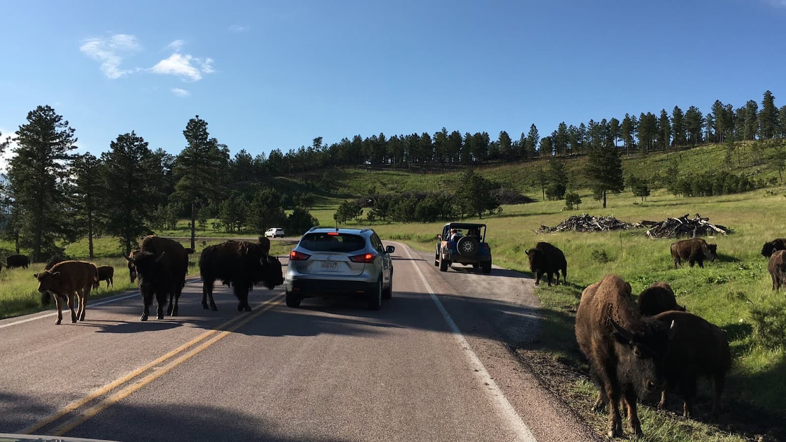
You might spot various wildlife, including bison, pronghorn, deer, and prairie dogs, especially within Custer State Park. Always maintain a safe distance and never feed the animals.
Cell service can be spotty and unreliable along Iron Mountain Road due to the mountainous terrain. It's advisable to download offline maps and information before you start your drive.
🎫 🚗 Driving & Navigation
The road is famous for its 314 curves and 7 tunnels. Expect steep grades, sharp turns, and narrow passages. It requires your full attention, especially if you're not used to mountain driving.
Standard traffic laws apply. However, due to the curves and tunnels, it's crucial to maintain a safe speed, use your headlights in tunnels, and be aware of oncoming traffic.
A pigtail bridge is a unique engineering feature where the road loops over itself in a spiral to gain or lose elevation on steep terrain. Iron Mountain Road has several of these distinctive bridges.
GPS can be helpful, but as mentioned, cell service is unreliable. It's best to have a physical map or download offline maps of the area before you begin your drive.
Pack water, snacks, a camera, sunscreen, and comfortable shoes. Layers of clothing are recommended as temperatures can vary. A physical map is also a good idea.


Social
from TikTok, Instagram & Reddit