
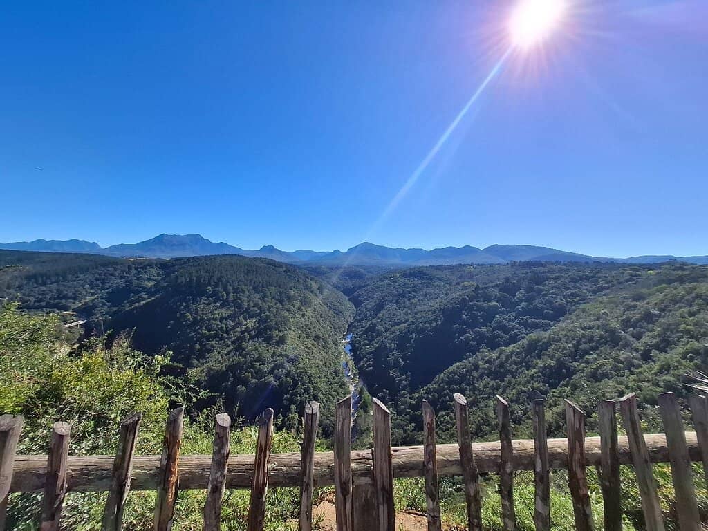
Map of Africa Viewpoint
A natural wonder where a river valley forms the shape of Africa, offering stunning panoramic views and paragliding thrills.

Highlights
Must-see attractions

Social
From TikTok & Reddit
Best Time
Clear views of the landscape
Map of Africa Viewpoint
Best Time
Clear views of the landscape
Highlights
Must-see attractions
A natural wonder where a river valley forms the shape of Africa, offering stunning panoramic views and paragliding thrills.
"It is absolutely worth the visit. Short drive on mostly a grave road from Wilderness."

🚗 Gravel Road Access
The last part is gravel, but usually easy to navigate. Drive carefully! 🚗
👥 Go with a Group
Some visitors suggest going in a group for safety. :bustsinsilhouette:

Quick Facts
Hours
Rating
4.5 · 2,536 reviews
Type
Tourist Attraction
Highlights
Discover the most iconic attractions and experiences
The 'Map of Africa' Formation
Main viewpoint
Witness the incredible natural resemblance of the landscape to the African continent, shaped by the Kaaimans River.
Paragliding Launch Site
Adjacent to the main viewpoint
Watch paragliders take flight against a stunning backdrop, or even take a tandem jump for an adrenaline rush.

Panoramic Wilderness Views
Overlooking Wilderness
Enjoy sweeping vistas of the Wilderness coastline, mountains, and lush forests, offering the best of both worlds.
Plans like a pro.
Thinks like you
Planning Your Visit
Timing is Key for the Best Views
Access and Safety Considerations
Best Times
Insider Tips
from TikTok, Instagram & Reddit
🚗 Gravel Road Access
The last part is gravel, but usually easy to navigate. Drive carefully! 🚗
👥 Go with a Group
Some visitors suggest going in a group for safety. :bustsinsilhouette:
📸 Perfect Photo Spot
This iconic spot is ideal for capturing stunning Instagram-worthy shots. :camerawithflash:
🪂 Paragliding Views
Catch paragliders in action or book a tandem flight for an unforgettable experience. :paragliding:
Tips
from all over the internet
🚗 Gravel Road Access
The last part is gravel, but usually easy to navigate. Drive carefully! 🚗
👥 Go with a Group
Some visitors suggest going in a group for safety. :bustsinsilhouette:
📸 Perfect Photo Spot
This iconic spot is ideal for capturing stunning Instagram-worthy shots. :camerawithflash:
🪂 Paragliding Views
Catch paragliders in action or book a tandem flight for an unforgettable experience. :paragliding:
💰 It's Free!
Enjoy the breathtaking views without any admission fee. :moneywithwings:
What Travellers Say
Reviews Summary
Visitors consistently praise the Map of Africa Viewpoint for its stunning, unique natural formation that strikingly resembles the continent of Africa. The panoramic views of the Wilderness coastline and mountains are also highly appreciated. While the gravel road access and occasional safety concerns are noted, the free entry and the spectacle of paragliding add to its appeal.
"Really beautiful sight to enjoy the freedom of picturing the Map of Africa or a crocodile head. Well worth the drive to this viewpoint. And not far from it, paragliding on your own or with an instructor."
Avril van der Merwe
"Views are the same as the rest of the places I visited, so is it worth the drive and the time? I would personally say no.
There is a lady who is there as an unofficial commentator expecting tips."
Thomas Joseph
"The shape of land is interesting. You need to pass gravel road at the final section but very easy road. There are not many people here. To me, the place for paragliding was much better. It is just in front of Map of Africa and the view is great! But that site is private property. When I went there, the gate was open. But need to check it"
Mothusi
What People Like
What People Dislike
Frequently Asked Questions
🚇 🗺️ Getting There
The viewpoint is located just outside Wilderness, South Africa. You'll drive on a gravel road for the final section, which is generally manageable for most vehicles. Some travelers mention it's a worthwhile drive, even if it's a few hours away.
The final part of the road leading to the viewpoint is a gravel road. While usually easy to navigate, it's advisable to drive cautiously. +1
Information on public transport directly to the viewpoint is limited. It's generally recommended to have your own vehicle or arrange private transport for easier access.
The viewpoint is a short drive from Wilderness, often described as being in Wilderness Heights or Hoekwil. +1
The drive involves a gravel road for the last few kilometers. It's generally considered easy but requires careful driving.
🎫 🎫 Tickets & Entry
No, the Map of Africa Viewpoint is free to visit. There are no admission fees, making it an accessible attraction.
The viewpoint is accessible during daylight hours. It's best to visit when there's ample natural light to appreciate the landscape.
No booking is required as there is no entrance fee. You can visit anytime during daylight hours.
Yes, there is plenty of parking available at the Map of Africa Viewpoint.
The paragliding launch site is adjacent to the main viewpoint. While the viewpoint itself is free, the paragliding site might be on private property, so check access.
📸 📸 Photography & Views
Early mornings and late afternoons offer the best light for photography, with softer shadows and a more dramatic effect on the landscape.
The viewpoint is famous for the natural formation of the landscape that strikingly resembles the continent of Africa, with the Kaaimans River tracing its outline. +1
Besides the 'Map of Africa' formation, you can enjoy stunning panoramic views of the Wilderness coastline, mountains, and lush forests.
Absolutely! The unique shape of the land and the surrounding scenery make it an iconic spot for Instagram-worthy pictures.
Yes, the Map of Africa Viewpoint is also a popular launch site for paragliders. You can often see them soaring through the air.
🎫 ⚠️ Safety & Tips
Some visitors have reported encountering 'dodgy characters' and recommend visiting in a group for added safety. Be aware of your surroundings.
Bring your camera for photos, comfortable shoes for walking around, and perhaps some water. Sunscreen and a hat are also advisable. :camerawithflash: :athletic_shoe: :droplet:
Yes, children can enjoy the views and the open space. However, adult supervision is recommended, especially near any edges. :child:
Take your time to admire the unique landscape, capture photos, and if possible, watch the paragliders. Enjoy the peaceful atmosphere. :peace_symbol:
Information on specific facilities like restrooms is not widely available, so it's best to be prepared.


Social
from TikTok, Instagram & Reddit