
Plans-Mayens
Explore the historic 'bisses' of Plans-Mayens, ancient irrigation channels offering serene walks through breathtaking Swiss alpine landscapes.
Highlights
Must-see attractions

Social
From TikTok & Reddit
Best Time
Fewer crowds, pleasant weather
Plans-Mayens
Best Time
Fewer crowds, pleasant weather
Highlights
Must-see attractions
Explore the historic 'bisses' of Plans-Mayens, ancient irrigation channels offering serene walks through breathtaking Swiss alpine landscapes.

👟 Wear Sturdy Footwear
Trails can be uneven; comfortable hiking shoes are essential for enjoying the bisses.
💧 Carry Water & Snacks
While beautiful, amenities are sparse. Pack essentials for your hike.

Quick Facts
Highlights
Discover the most iconic attractions and experiences

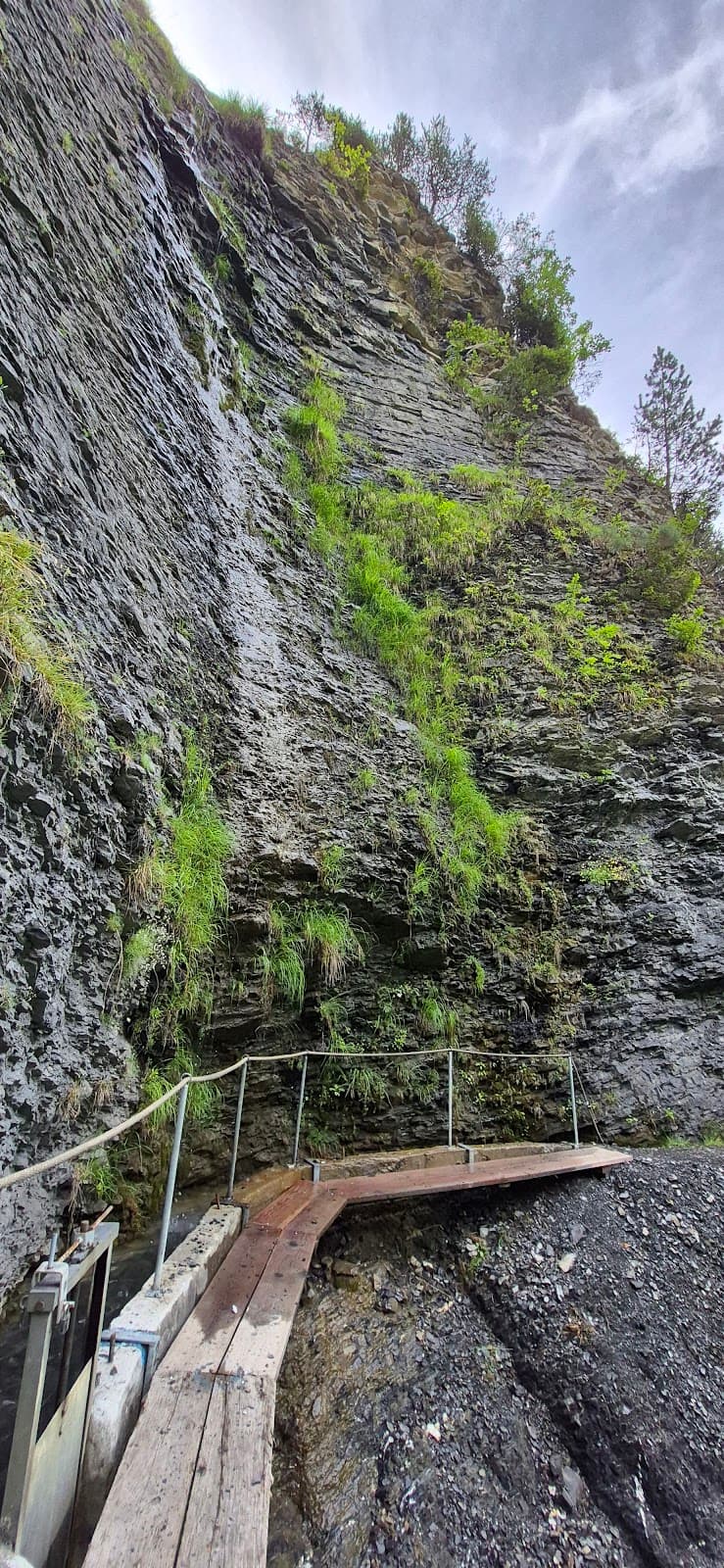
Bisse du Ro
Val d'Anniviers
Walk alongside ancient irrigation channels, offering unique perspectives and serene natural beauty. A must-do for hikers.

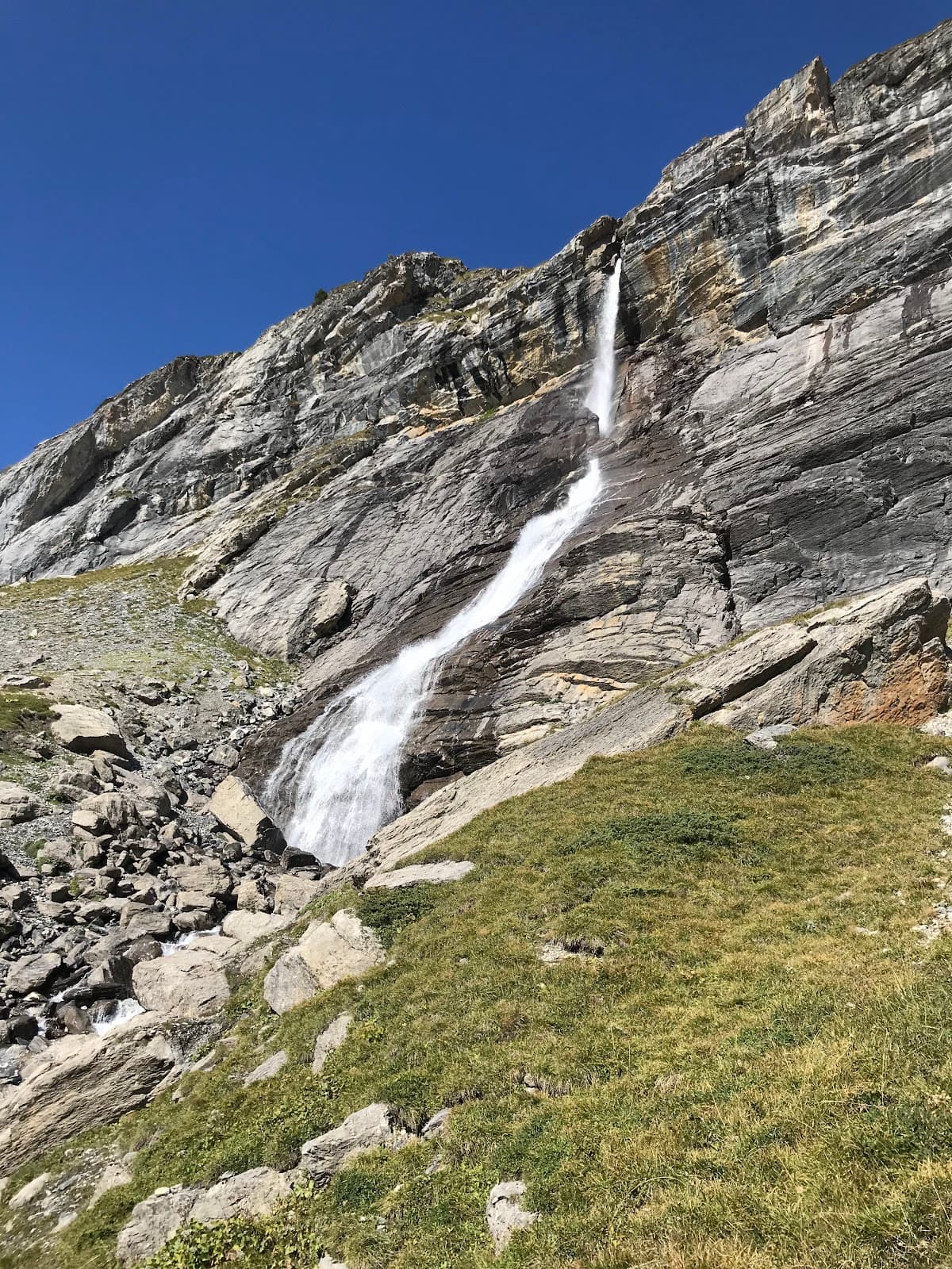
Panoramic Mountain Views
Various points along the trails
Experience breathtaking vistas of the surrounding Swiss Alps. Perfect for photography and soaking in the alpine atmosphere.

Local Flora and Fauna
Along the bisses
Discover the diverse plant life and potential wildlife encounters unique to the alpine environment. A peaceful nature walk.
Plans like a pro.
Thinks like you
Planning Your Visit
Embrace the Scenic Trails
Best Time for Peaceful Exploration
Best Times
Insider Tips
from TikTok, Instagram & Reddit
👟 Wear Sturdy Footwear
Trails can be uneven; comfortable hiking shoes are essential for enjoying the bisses.
💧 Carry Water & Snacks
While beautiful, amenities are sparse. Pack essentials for your hike.
🗺️ Download Offline Maps
Cell service can be spotty. Ensure you have offline maps for navigation.
☀️ Check Weather Forecast
Alpine weather changes rapidly. Be prepared for sun, rain, or cooler temperatures.
Crans Montana for US East Coast skiers?
I am currently weighing a surprise birthday trip in early March for my husband to Crans-Montana or Park City, Utah. As an Epic pass holder, I'm *set* on Crans Montana or Andermatt. However, Crans Montana seems easier to access via train. But we are Boston area skiers,…
Tips
from all over the internet
👟 Wear Sturdy Footwear
Trails can be uneven; comfortable hiking shoes are essential for enjoying the bisses.
💧 Carry Water & Snacks
While beautiful, amenities are sparse. Pack essentials for your hike.
🗺️ Download Offline Maps
Cell service can be spotty. Ensure you have offline maps for navigation.
☀️ Check Weather Forecast
Alpine weather changes rapidly. Be prepared for sun, rain, or cooler temperatures.
What Travellers Say
Reviews Summary
Visitors rave about the unique and serene experience of walking along the ancient bisses in Plans-Mayens, appreciating the historical significance and stunning alpine scenery. While the natural beauty is a major draw, some find the lack of facilities and occasional trail maintenance issues a minor drawback.
What People Like
What People Dislike
Frequently Asked Questions
🚇 🗺️ Getting There
Plans-Mayens is typically accessed via the Val d'Anniviers region in Switzerland. Driving is common, with parking available near trailheads. Public transport options might involve buses to nearby villages, followed by a hike.
While direct public transport to every bisse point might be limited, buses serve the Val d'Anniviers. You may need to combine bus travel with walking or a short taxi ride.
The primary way to explore Plans-Mayens is by hiking the bisses. For longer distances between trailheads, a car or local bus services are options.
Car rentals are generally available in larger towns or cities in the Valais canton, such as Sion. Renting a car offers the most flexibility for reaching different bisse starting points.
Roads leading to the Val d'Anniviers are generally well-maintained, but can be winding. During winter, check for snow conditions and potential closures.
🎫 🎫 Tickets & Entry
No, access to the bisses and hiking trails in Plans-Mayens is generally free. It's a natural attraction open to the public.
There are no specific entrance fees for Plans-Mayens itself. Enjoying the natural beauty and hiking trails is free of charge.
The bisses are natural irrigation channels and are accessible at all times. However, daylight hours are recommended for safety and enjoyment.
Yes, guided tours are often available, especially during peak season, offering insights into the history and ecology of the bisses. Check with local tourist information offices.
While there might not be a dedicated visitor center directly at every bisse, tourist information offices in nearby villages like Grimentz or Zinal can provide maps and advice.
🎫 🏞️ Onsite Experience
Plans-Mayens features a network of 'bisses' or ancient irrigation channels, which form unique, often flat or gently sloping walking paths. Some connect to more challenging mountain trails.
Many bisses are relatively flat and safe, making them suitable for families. However, always supervise children closely, as some sections might be narrow or have steep drops.
Using a good hiking map or a GPS device with downloaded offline maps is recommended. Trail markers can vary in clarity.
Facilities are very limited along the bisses themselves. Plan to use restrooms in nearby villages before starting your hike.
You might encounter various alpine birds, small mammals, and diverse plant life. Keep an eye out for chamois or ibex in higher altitudes.
📸 📸 Photography
Look for viewpoints overlooking the valleys, the unique architecture of the bisses themselves, and the surrounding snow-capped peaks. Golden hour offers beautiful light.
A versatile lens (like a 24-70mm) is great for landscapes and details. A wide-angle lens can capture the expansive mountain scenery. Consider a polarizing filter for vibrant skies.
Early morning and late afternoon (golden hours) provide soft, warm light and dramatic shadows, ideal for landscape photography. Midday sun can be harsh.
The bisses themselves, with their historical significance and integration into the landscape, are unique subjects. Also, capture the wildflowers in spring and the autumn colors.
Weather can change quickly, impacting light and visibility. Limited accessibility to certain viewpoints might require hiking.


Social
from TikTok, Instagram & Reddit