
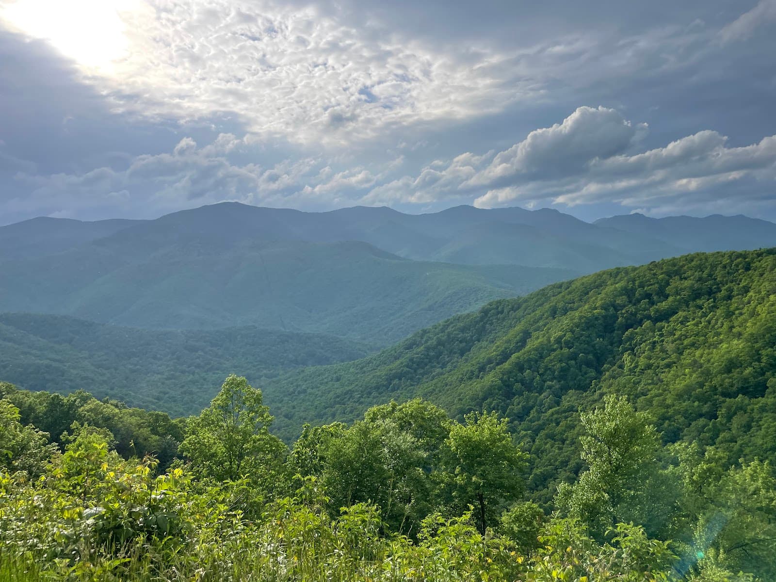
Middle Prong Wilderness
Discover stunning waterfalls and rugged mountain scenery in Middle Prong Wilderness, a remote escape for hikers and nature lovers.

Highlights
Must-see attractions

Social
From TikTok & Reddit
Best Time
Waterfalls are at their best
Middle Prong Wilderness
Best Time
Waterfalls are at their best
Highlights
Must-see attractions
Discover stunning waterfalls and rugged mountain scenery in Middle Prong Wilderness, a remote escape for hikers and nature lovers.
"This place is full of beautiful waterfalls and scenery!! Some of the trails are easy, but some can be dangerous if you want to see everything. "

🗺️ Download Offline Maps
Cell service is spotty. Download maps before you go to navigate the unmarked trails.
🥾 Wear Sturdy Footwear
Trails can be rugged and involve creek crossings. Good hiking boots are essential.

Quick Facts
Highlights
Discover the most iconic attractions and experiences
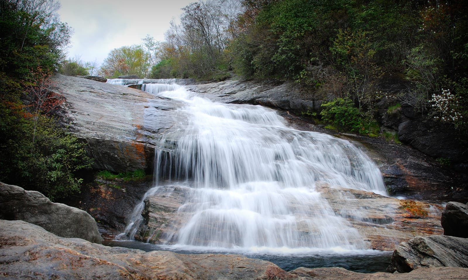
Sunburst Falls
Along Hwy 215
A stunning roadside waterfall with upper and lower sections, easily accessible without a hike. Perfect for a quick nature stop.

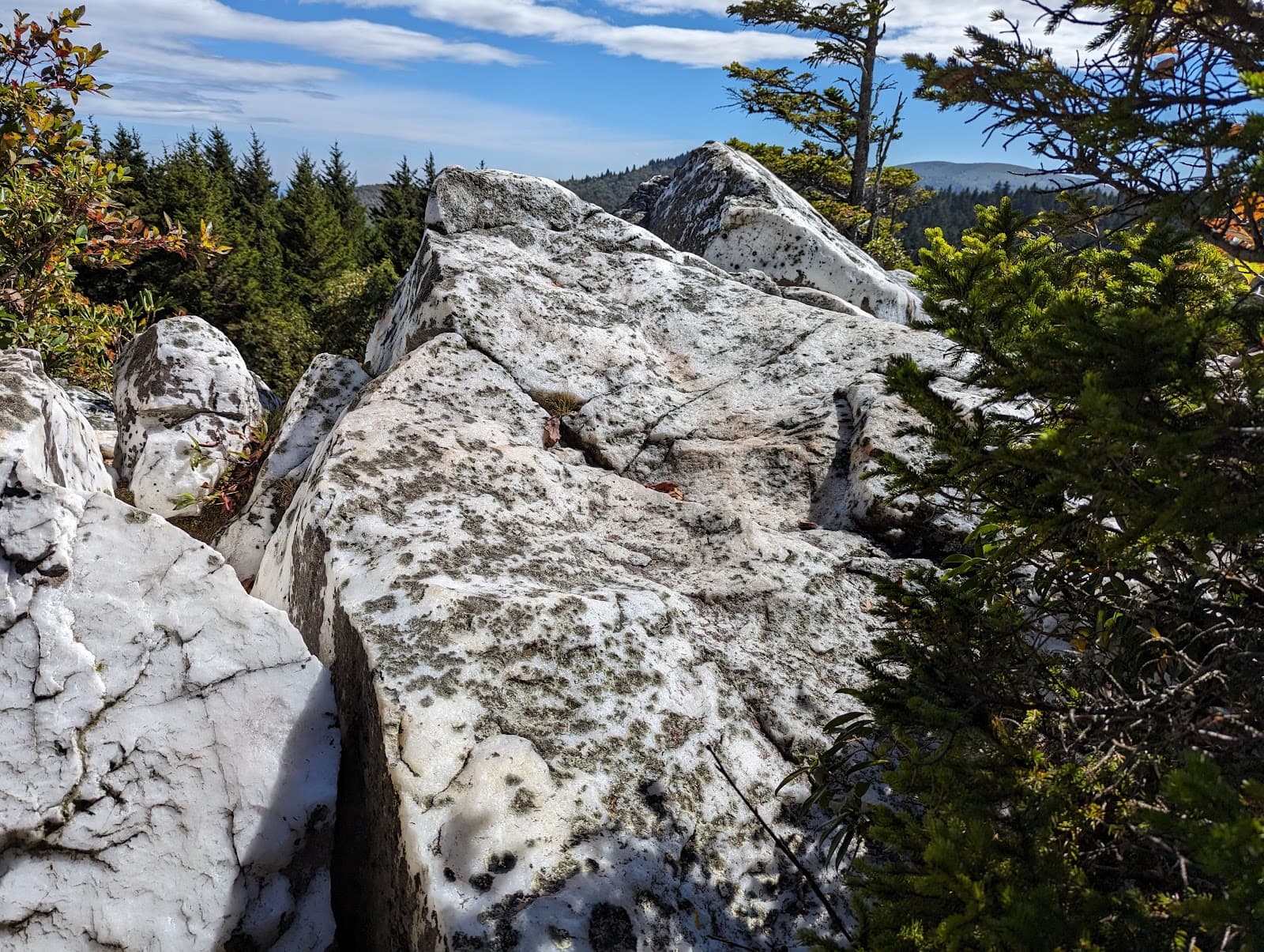
Black Balsam Knob
Middle Prong Wilderness, NC
Offers breathtaking 360-degree views from 6200 ft elevation. A moderate 1.4-mile out-and-back hike.

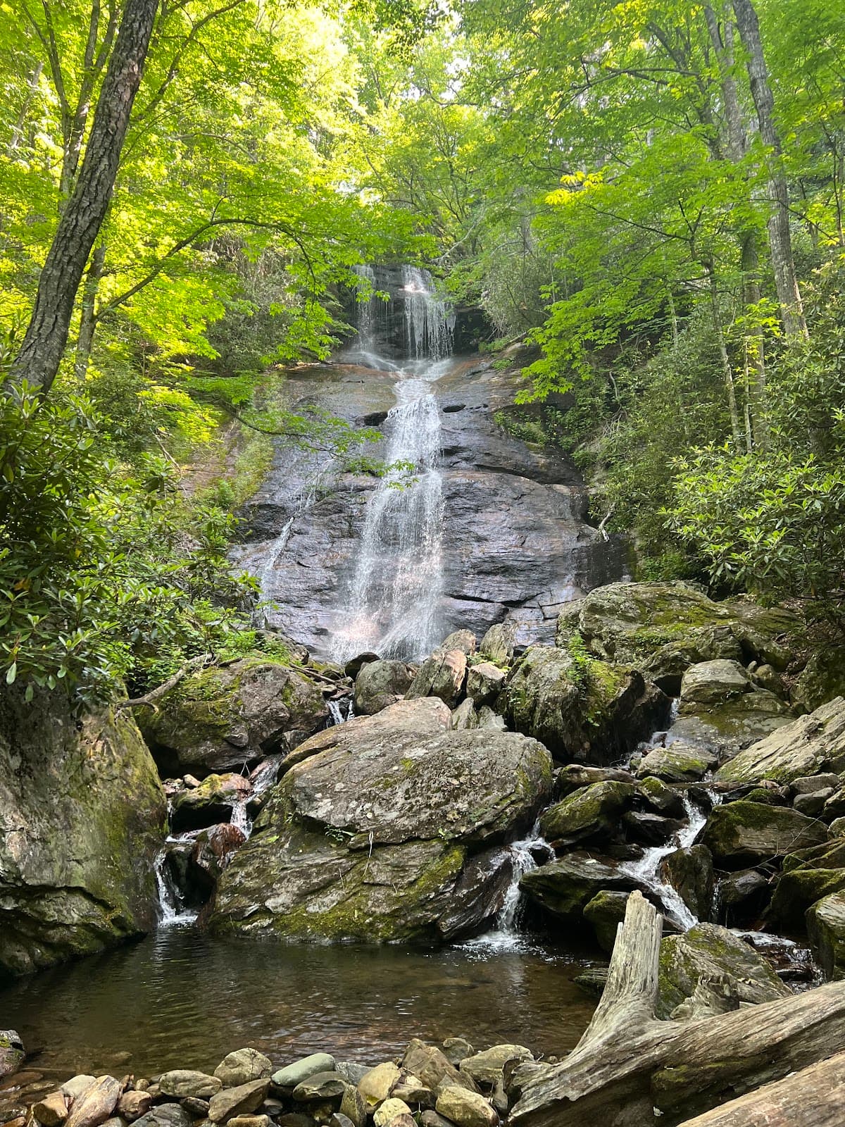
Tiger Falls
Middle Prong Wilderness
A beautiful cascade featuring four distinct drops, best viewed after a good rain.

Big Beartrap Falls
Inside Middle Prong Wilderness
One of many impressive waterfalls on the creek, though some are harder to access.
Plans like a pro.
Thinks like you
Planning Your Visit
Embrace the Wilderness: Be Prepared
Timing is Key for Waterfalls
Best Times
Insider Tips
from TikTok, Instagram & Reddit
🗺️ Download Offline Maps
Cell service is spotty. Download maps before you go to navigate the unmarked trails.
🥾 Wear Sturdy Footwear
Trails can be rugged and involve creek crossings. Good hiking boots are essential.
💧 Check Water Levels
Creek crossings can be difficult after heavy rain. Assess conditions before attempting.
☀️ Beat the Heat
On hot summer days, the cool waters offer a refreshing dip.
Tips
from all over the internet
🗺️ Download Offline Maps
Cell service is spotty. Download maps before you go to navigate the unmarked trails.
🥾 Wear Sturdy Footwear
Trails can be rugged and involve creek crossings. Good hiking boots are essential.
💧 Check Water Levels
Creek crossings can be difficult after heavy rain. Assess conditions before attempting.
☀️ Beat the Heat
On hot summer days, the cool waters offer a refreshing dip.
🌿 Respect the Ecosystem
Observe biodiversity like millipedes and lichens without disturbing them.
What Travellers Say
Reviews Summary
Visitors rave about the stunning waterfalls and rugged beauty of Middle Prong Wilderness, with Sunburst Falls being a particular highlight for its accessibility. While many enjoy the remote, natural feel and opportunities for refreshing dips, some caution that trails can be dangerous, unmarked, and confusing, requiring significant preparation and navigation skills.
"This place is full of beautiful waterfalls and scenery!! Some of the trails are easy, but some can be dangerous if you want to see everything this place has to offer. Middle Prong falls, Little Beartrap Falls, and Boomer Inn Falls (upper and lower) might be just outside the boundary, but they are worth seeing also. Inside the wilderness you can see Big Beartrap Falls and all the other waterfalls on this creek. Some people say there are more than 10 on this creek, but they are hard to get to. Go in the spring or after a good rain. Buckeye Falls and the other waterfalls on Buckeye creek are worth the effort if you don’t mind hiking off trail. There are some creek crossings that can be difficult if the water is up."
Kipp White
"There are two ways to get into this wilderness from the Sunburst campground/picnic area, coming from Canton, NC. You can hike up into the wilderness on Forest Service Road #97. This road is gravel, and you can easily miss the entrance into the wilderness. The wilderness entrance is in the second sharp switchback on the left. Option #2 is crossing the Pigeion River on Hwy. 215, and choosing the Green Mountain Trail, which immediatley starts steeply after the bridge. The Green Mountain Trail is brutally steep, and there are no water sources on this entire trail. From my personal experinece, this trail is more difficult on the downward decsent, coming from Mt. Hardy, as opposed to climbing it from Sunburst. Once you enter the dense green evergreen canopy, at the terminus of the Green Mountain Trail, at the MST Trail, you will experience an eire dark and quiet evergreen forest. The sunligt disappears, and you are enveloped in a dark green canopy and mossy covered forest floor. Hiking through this high altitude evergreen forest is truly a surreal experince. Water is approximately .5 miles down the trail heading North. There is water going the opposite direction, towads Hwy. 215 apx. .5 miles. Continuing the clockwise hike, decending in elevation, you will eventually empty into a beautiful level camping area along the West Fork of the Pigeon River. From here, it is a one mile hike back to Sunburst, NC and the campground/picnic area."
Tim Terry
"Great outing for a hot summer day. My wife and I went on a weekday and did not see a soul. I one point I was overheating and the water looked so inviting that I stripped down to my shorts for a refreshing dip."
Matt Kulpinski
What People Like
What People Dislike
Frequently Asked Questions
🚇 🗺️ Getting There
Two main access points exist from Sunburst Campground/Picnic Area. You can hike up Forest Service Road #97 (look for the wilderness entrance at the second switchback) or cross the Pigeon River on Hwy. 215 and take the steep Green Mountain Trail.
Yes, parking is available at the Sunburst campground/picnic area. For Black Balsam Knob, you can park at the trailhead on Black Balsam Rd or at the lot at the end of the road, which has bathrooms.
Public transport options are very limited for accessing remote wilderness areas like Middle Prong. It is best to have your own vehicle.
Forest Service Road #97 is gravel and can be easily missed. The Green Mountain Trail is described as brutally steep.
For waterfalls like Sunburst Falls, access is directly from Hwy 215. For interior falls, consider the trails from Sunburst Campground.
🎫 🎫 Tickets & Entry
Generally, no specific permits are required for day hiking in Middle Prong Wilderness, but always check current regulations with the Pisgah National Forest.
There are no direct entrance fees for the wilderness area itself. However, parking at areas like Sunburst Campground may have associated fees or require a recreation pass.
As a wilderness area, Middle Prong is generally accessible year-round during daylight hours. However, road access may be limited in winter.
Dispersed camping is often permitted in wilderness areas, but regulations can vary. It's advisable to research specific backcountry camping rules for Pisgah National Forest.
Yes, drone flights are technically prohibited in Middle Prong Wilderness due to its designation.
🎫 🧭 Onsite Experience
Trails range from easy roadside access to rugged, unmarked, and off-trail routes. Be prepared for steep climbs and creek crossings.
Hikes can be challenging, especially those involving elevation gain or off-trail navigation. Some trails are described as 'brutally steep.'
Absolutely! The area is renowned for its numerous waterfalls, including Sunburst Falls, Tiger Falls, and Big Beartrap Falls. +1
You might encounter diverse flora and fauna, including millipedes, lichens, and various plant species.
Yes, many visitors enjoy day trips to see specific waterfalls or viewpoints like Black Balsam Knob. +1
📸 📸 Photography
Waterfalls like Sunburst Falls and Tiger Falls, along with panoramic views from Black Balsam Knob, offer excellent photographic opportunities. +2
A sturdy tripod is helpful for capturing waterfalls, and a wide-angle lens can be great for landscapes. Consider waterproof gear if shooting near water.
Yes, the mossy, evergreen forest floor provides a unique and atmospheric subject for photography. +1
Early morning or late afternoon light can create beautiful conditions, especially for waterfalls and forest scenes.
The dense canopy can create low-light conditions, and unmarked trails require careful navigation.


Social
from TikTok, Instagram & Reddit