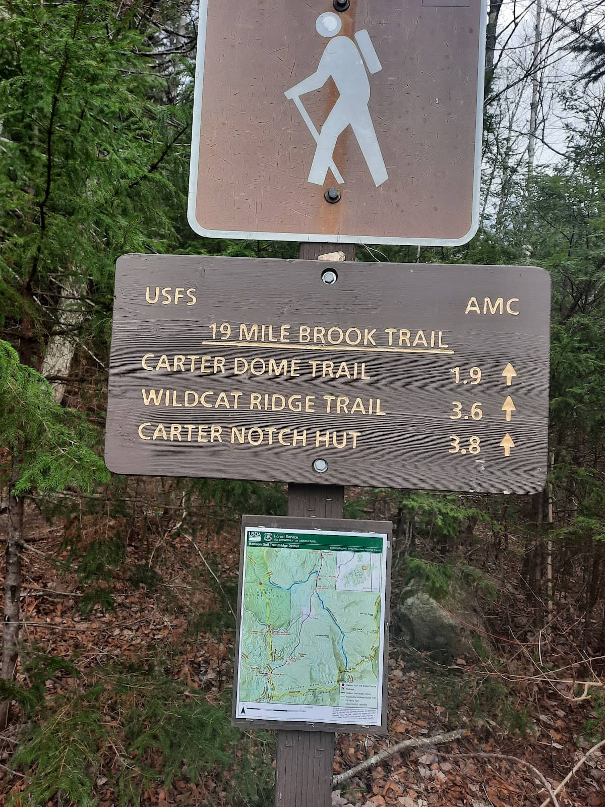
19 Mile Brook Trailhead
Gateway to challenging Carter Mountain hikes, featuring scenic brook trails and demanding ridgeline ascents.
Highlights
Must-see attractions

Social
From TikTok & Reddit
Best Time
Beat the heat and crowds
19 Mile Brook Trailhead
Best Time
Beat the heat and crowds
Highlights
Must-see attractions
Gateway to challenging Carter Mountain hikes, featuring scenic brook trails and demanding ridgeline ascents.
"This is a true test of endurance, offering challenging hikes with rewarding views."
💧 Carry Plenty of Water
Bring at least 4L of water, especially on hot days, as exposed ridgelines offer little shade. :droplet:
🗺️ Map & Compass Essential
GPS apps can be unreliable; a physical map and compass are crucial for navigation on longer hikes. 🧭
Quick Facts
Hours
Rating
4.8 · 96 reviews
Type
Hiking Area
Highlights
Discover the most iconic attractions and experiences
Carter Dome Summit
Carter Mountains
Conquer three 4,000-foot peaks on a challenging loop hike with rewarding, albeit exposed, ridgeline views.
Carter Notch Hut
Carter Notch
An accessible and pleasant hike along a beautiful brook leads to this historic hut, offering a gentler experience.
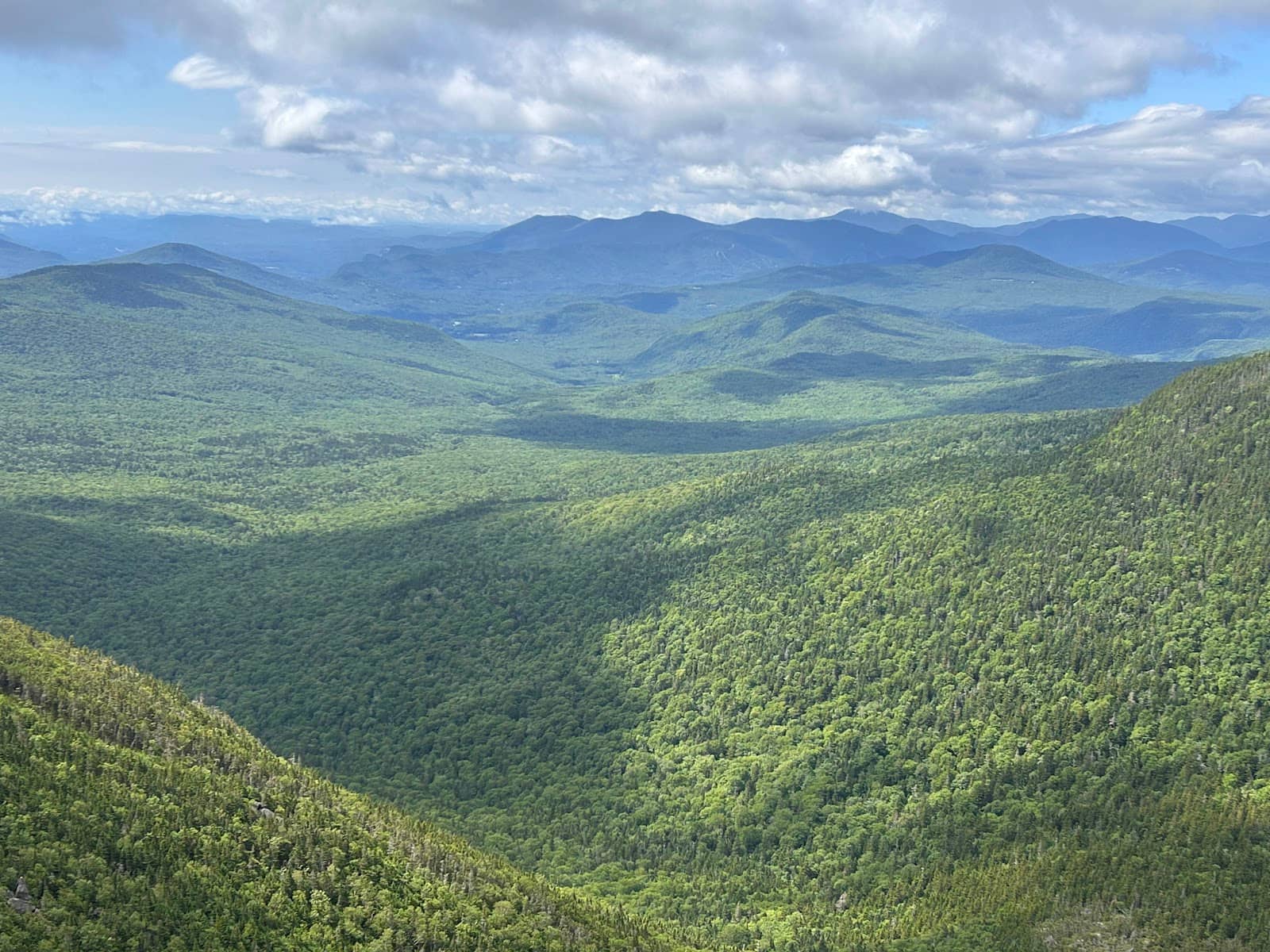
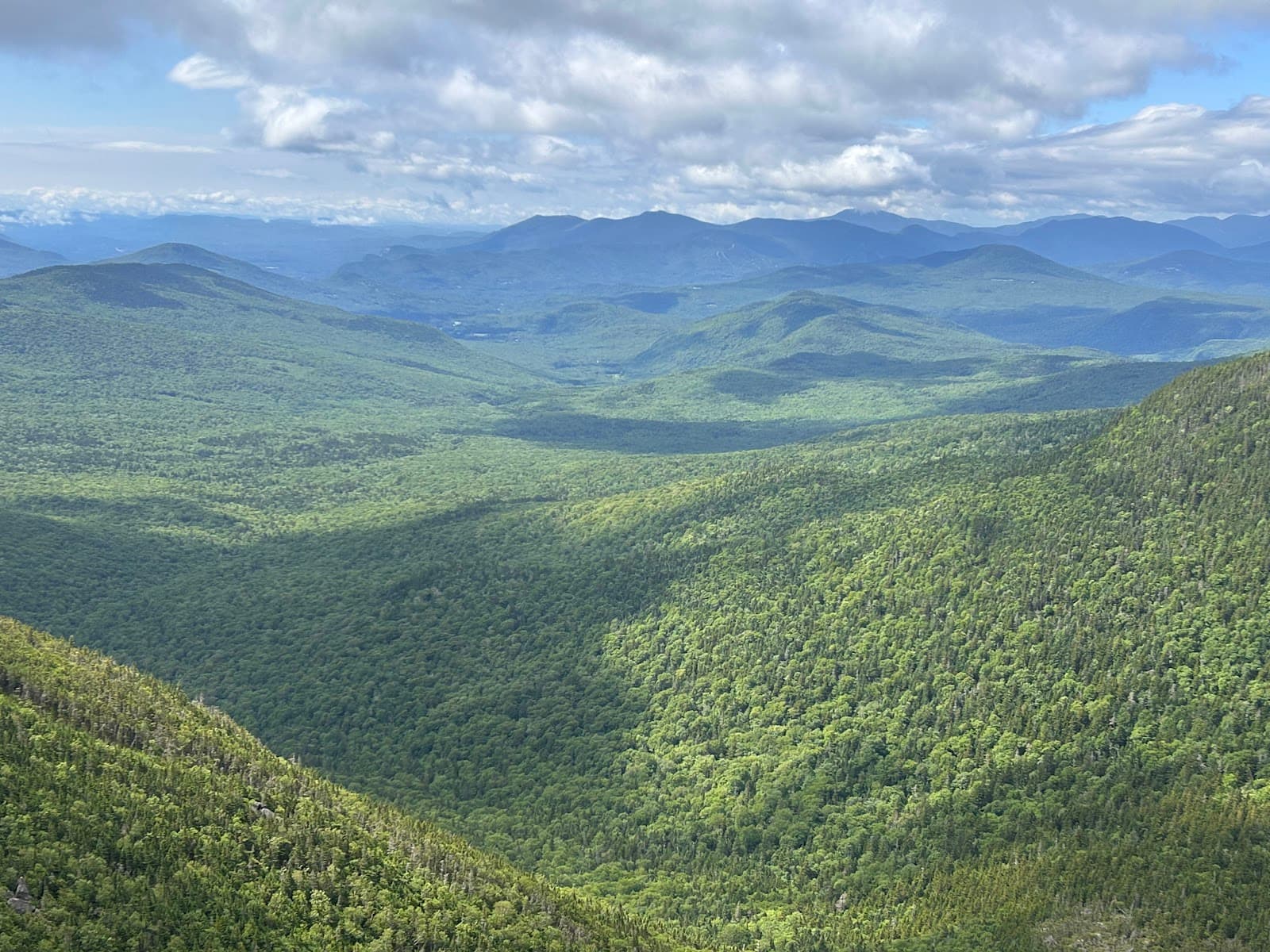
Mount Hight Viewpoint
Carter Mountains
Don't miss the unbelievable panoramic views from Mount Hight, a highlight of the Carter Dome loop hike.
Plans like a pro.
Thinks like you
Planning Your Visit
Prepare for a Challenging Trek
Trail Conditions & Navigation
Best Times
Insider Tips
from TikTok, Instagram & Reddit
Hitching a Ride from Gorham to Pinkham Notch Visitor Center
Hey All, looking to hitch a ride from Gorham to Pinkham Notch Visitor Center. It’d be on a Monday morning around 8am and I’d be solo. Anyone have experience? You think I’ll have any luck? Looking to do the Wildcats, Carter, Moriah traverse. South to North. TIA!
💧 Carry Plenty of Water
Bring at least 4L of water, especially on hot days, as exposed ridgelines offer little shade. :droplet:
🗺️ Map & Compass Essential
GPS apps can be unreliable; a physical map and compass are crucial for navigation on longer hikes. 🧭
Car logistics for soloing the Wildcats-Carters-Moriah Traverse
I'm interested in soloing the Wildcats-Carters-Moriah Traverse. Any suggestions on how to handle car logistics? Is one end point better for this? Are taxis or shuttles in Gorham available? Just hitch-hike?
Mt. Moriah descent - Stony Brook or Carter-Moriah?
I'm looking to do a Carters-Moriah traverse on Saturday starting at Nineteen Mile Brook Trail and heading up through Carter Notch to the Carter-Moriah Trail. This means that Moriah is my last planned summit. I would like to take the most gentle descent (fewer steep sections…
☀️ Sun Protection Needed
The ridgeline sections are exposed. Pack sunscreen, hats, and sun-protective clothing. ☀️
💪 Be Prepared for Length
Hikes can be long (14+ miles) and demanding. This is a true test of endurance. 💪
The best Mount Moriah trail- Stony Brook vs. Carter Moriah?
Looking for comparisons between the Stony Brook Trail and Carter Moriah trail from those who have done both. Specifically which one is easier, which one has the best views along the way, which one has water for filter refills, etc.? I'm a seasoned 4k foot hiker, so I'm just…
Tips
from all over the internet
💧 Carry Plenty of Water
Bring at least 4L of water, especially on hot days, as exposed ridgelines offer little shade. :droplet:
🗺️ Map & Compass Essential
GPS apps can be unreliable; a physical map and compass are crucial for navigation on longer hikes. 🧭
☀️ Sun Protection Needed
The ridgeline sections are exposed. Pack sunscreen, hats, and sun-protective clothing. ☀️
💪 Be Prepared for Length
Hikes can be long (14+ miles) and demanding. This is a true test of endurance. 💪
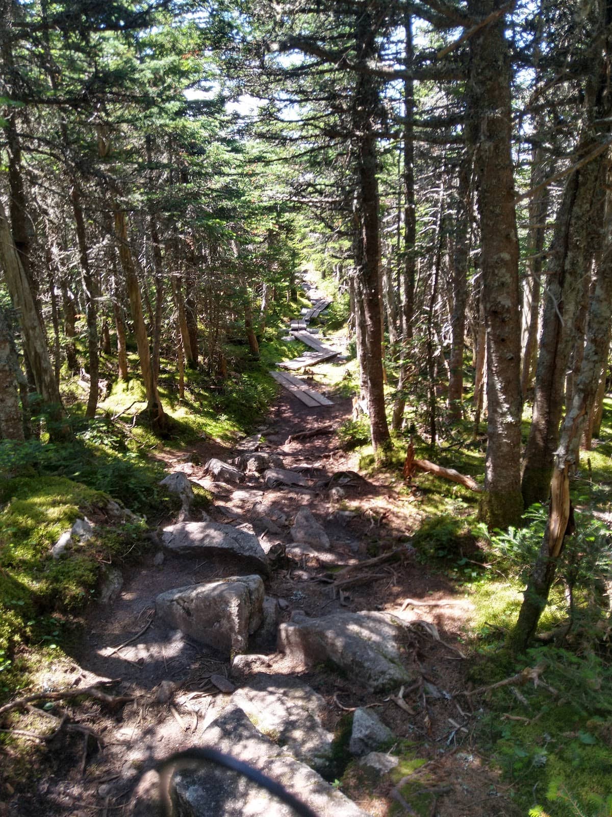
🌿 Watch for Overgrowth
Trails can be overgrown; expect to push through foliage and potentially get scraped arms. :evergreen_tree:
What Travellers Say
Reviews Summary
This trailhead offers access to challenging, long-distance hikes, particularly the Carter Mountains loop, which is praised for its endurance test and rewarding summit views. However, hikers should be prepared for significant mileage, potential overgrowth, and the need for ample water and sun protection. The initial section along the brook is noted as a pleasant, easier start.
"I started at this trailhead to hike the Carter Mountains, i did a loop hike per my book. Carter Dome, middle and south mountains. Got there at 0800 sharp on a Thursday, parking lot just about full. Get x3 4,000 footer peaks in 1 hike. Book says it's moderate to hard. I'd say mostly hard. The elevation isn't too bad but the length is what makes it hard. This is a true test of endurance. I did this on a 90 degree day, any hotter than that and you will be at very high risk for heat stroke. I brought 4L of water and that was almost not enough. A large majority of the hike is literally on the top of all the ridgelines of all the peaks exposed to the sun for most of it, which seemingly goes on forever! I hiked for 7.5 hours moving time, only took about ~45 min total breaks, did about ~14 miles. Alltrails was an epic fail for this mountain, it never knew where I was for the whole entire hike, good thing I had my map and well written directions. Not many sashes but the trails are pretty obvious, alot of overgrowth though, at times you are squeezing through overgrowth, my arms are all scraped up. Bring at least 4L water, don't go when it's hot, sunblock and sun protection for the top. Be sure to swing by Mt hight, that view was unbelievable! This tested the limits of what I was capable of and at times I thought I may not be able to do it, it was hard. Be prepared, this is a one and done for me. Very short road walk back to car. Follow directions closely!!"
jessica desilets
"Nice, easy elevation trail to Carter Notch hut.
Nice hike along river for first mile, easy hike for first 2 miles."
Mark Nadow
"Lovely hike next to a gorgeous brook/small river with lots of rapids, and the accompanying sound of rushing water. Medium grade slope so some effort but not overly challenging.
Walk is mostly under the tree canopy, and you have to connect to upper more challenging trails to get to the mountain views."
Ed Ebinger
What People Like
What People Dislike
Frequently Asked Questions
🚇 🗺️ Getting There
The trailhead is accessible via a road, but follow directions closely as it can be tricky. Parking lots can fill up quickly, especially on weekends.
Yes, there is a parking lot, but it can get full early, particularly on popular hiking days. Arrive early to secure a spot.
Specific directions should be followed carefully. Some users have noted that GPS can be unreliable in the area, so a physical map is recommended.
Public transport options are generally limited for trailheads in this region. It's best to plan for a private vehicle.
The road is generally passable, but it's advisable to check local conditions before your visit, especially after inclement weather.
🎫 🎫 Tickets & Entry
There are no tickets required for entry to the trailhead or the trails themselves. It's a public access area.
Typically, there are no entrance fees for this trailhead. However, always check for any posted notices regarding potential parking fees or permits.
The trailhead is generally accessible from dawn till dusk. There are no official operating hours, but it's best to hike during daylight.
No, parking spots are on a first-come, first-served basis. Arriving early is the best strategy to guarantee a spot.
While camping might be permitted in designated backcountry areas, it's not typically allowed at the trailhead itself. Check with local ranger districts for specific regulations.
🎫 🏞️ Onsite Experience
This trailhead offers access to challenging, long-distance hikes, including loops that summit multiple peaks like Carter Dome, Middle Carter, and South Carter.
While generally obvious, some sections may have less frequent blazes. Overgrowth can also obscure the path at times.
Hikes are generally considered moderate to hard, with significant length and elevation gain contributing to the difficulty.
Yes, peaks like Mount Hight offer unbelievable panoramic views. However, some summit views might be limited or mostly treed.
The first mile or two along the river can be pleasant and relatively easy, but most trails quickly become more challenging.
🎫 💧 Water & Facilities
There are no facilities providing potable water at the trailhead. You must carry all the water you need for your hike.
The brook itself offers a water source, but it's essential to have a reliable water filter or purification method if you plan to refill.
Restroom facilities are typically not available at this trailhead. Plan accordingly and use facilities before you arrive.
The trailhead primarily offers parking. There are no other amenities like visitor centers or picnic areas.
It's recommended to bring at least 4 liters of water per person, especially for longer, more strenuous hikes, and on hot days.
📸 📸 Photography
The brook itself offers beautiful shots with rapids and lush greenery. Summit views, particularly from Mount Hight, are also spectacular.
Yes, the initial part of the trail follows a gorgeous brook with rapids, providing excellent opportunities for nature photography.
A versatile lens for landscapes and potentially a wider aperture for forest shots would be beneficial. Consider a lightweight setup for challenging hikes.
While summit views can be stunning, attempting sunrise or sunset hikes requires careful planning due to trail difficulty and darkness. Mount Hight is a prime candidate.
The lower sections are often under tree canopy, offering dappled light. Ridges are fully exposed, so midday sun can be harsh.


Social
from TikTok, Instagram & Reddit