
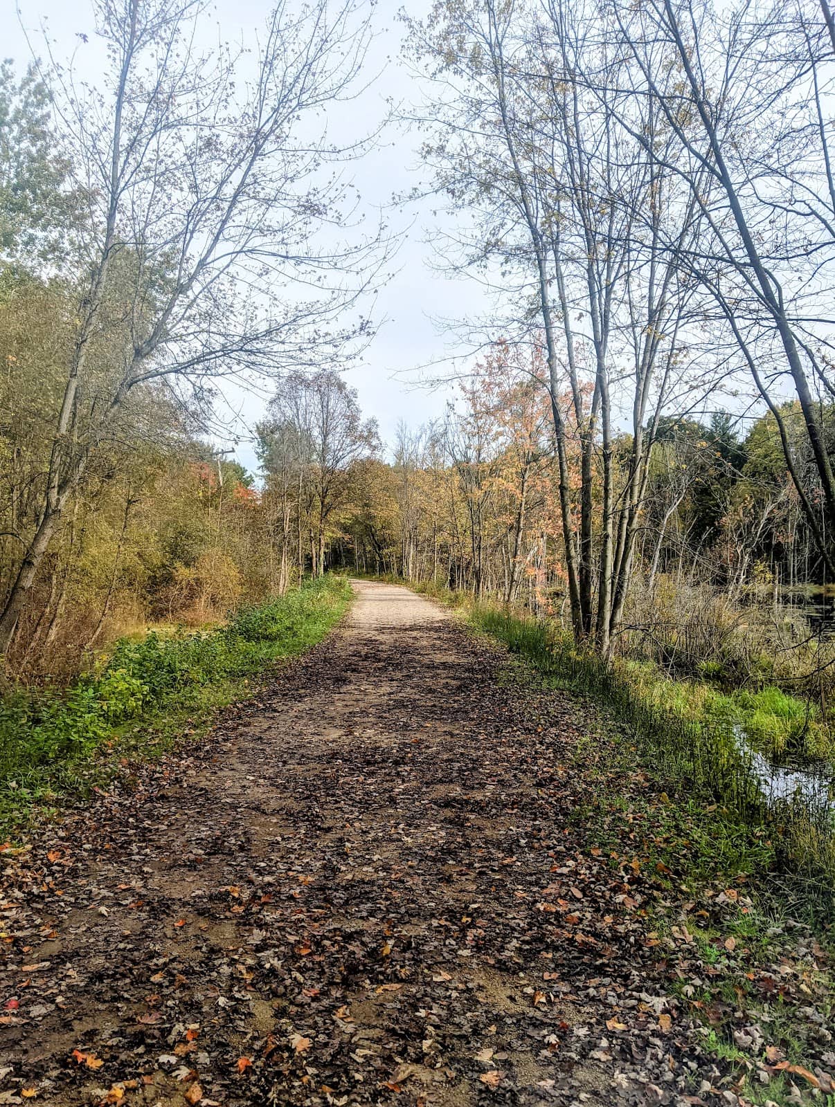
Polly Ann Trail
A 16.9-mile former railroad corridor offering a flat, scenic path for biking, walking, and connecting to the Paint Creek Trail.
Highlights
Must-see attractions

Social
From TikTok & Reddit
Best Time
Mild weather, fewer crowds
Polly Ann Trail
Best Time
Mild weather, fewer crowds
Highlights
Must-see attractions
A 16.9-mile former railroad corridor offering a flat, scenic path for biking, walking, and connecting to the Paint Creek Trail.
"Experience a peaceful journey through nature and history on this beautiful former railroad trail."
🚴♀️ Bike Rentals Available
Oxford Bike Shoppe offers rentals, perfect for exploring the Polly Ann Trail.
👟 Wear Comfortable Shoes
The trail is mostly flat, ideal for walking, running, or biking.

Highlights
Discover the most iconic attractions and experiences
Scenic Railroad Corridor
Entire length of the trail
Experience a unique journey along a former railroad line, now a peaceful, tree-lined path.
Paint Creek Trail Connection
Near Clarkston Road
Seamlessly transition to the Paint Creek Trail for an extended biking adventure.
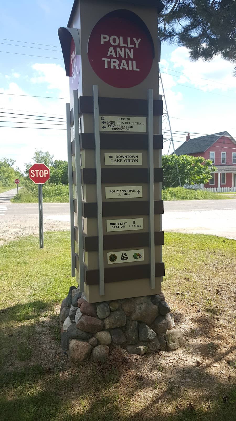
Community Access Points
Orion Township, Oxford
Enjoy easy access and explore charming towns along the 16.9-mile trail.
Plans like a pro.
Thinks like you
Planning Your Visit
Trail Etiquette & Connections
Parking & Access Points
Best Times
Insider Tips
from TikTok, Instagram & Reddit
🚴♀️ Bike Rentals Available
Oxford Bike Shoppe offers rentals, perfect for exploring the Polly Ann Trail.
👟 Wear Comfortable Shoes
The trail is mostly flat, ideal for walking, running, or biking.
🗺️ Download Trail Maps
Essential for navigating the trail and its connections.
💧 Stay Hydrated
Bring water, especially on longer rides or walks.
Tips
from all over the internet
🚴♀️ Bike Rentals Available
Oxford Bike Shoppe offers rentals, perfect for exploring the Polly Ann Trail.
👟 Wear Comfortable Shoes
The trail is mostly flat, ideal for walking, running, or biking.
🗺️ Download Trail Maps
Essential for navigating the trail and its connections.
💧 Stay Hydrated
Bring water, especially on longer rides or walks.
🌳 Enjoy Nature's Serenity
The trail offers a peaceful escape and a chance to connect with nature.
What Travellers Say
Reviews Summary
Visitors praise the Polly Ann Trail for its peaceful, scenic beauty and its suitability for biking and walking. The trail's historical railroad corridor design offers a unique and accessible experience, with many appreciating its connection to the Paint Creek Trail. Some users note the presence of historical sites along the route, adding a layer of local interest.
What People Like
What People Dislike
Frequently Asked Questions
🚇 🗺️ Getting There
Parking is available in several communities along the trail, including Orion Township and Oxford. It's recommended to consult a Polly Ann Trail map to identify specific parking areas and access points.
From Auburn Hills, you can typically access the Polly Ann Trail by driving north towards Orion Township or Oxford. The trail is part of a network of trails in the region, so checking a detailed map is advised.
Public transport options directly to trailheads are limited. Driving to a designated parking area is the most common way to access the Polly Ann Trail.
Yes, the Polly Ann Trail connects to the Paint Creek Trail, offering an extended route for cyclists. This connection is a popular feature for longer rides. +1
You can find the Polly Ann Trail map online through local park district websites or by searching for 'Polly Ann Trail map' or 'Polly Ann bike trail map'.
🎫 🎫 Tickets & Entry
The Polly Ann Trail is a public trail and generally does not require an entrance fee for access. Enjoy the natural beauty and recreational opportunities for free.
As an outdoor public trail, the Polly Ann Trail is typically accessible from dawn to dusk. Specific park hours at access points may vary, so it's good to check local information.
No permit is generally required to bike on the Polly Ann Trail. It's a public recreational path open to all.
Standard trail etiquette applies: stay to the right, yield to faster users, and be mindful of other visitors. Leashed pets are usually welcome.
While the trail itself is open, it's best to avoid using it after dark for safety reasons. Many access points may have closing times for parking areas.
🎫 🚶 Onsite Experience
The Polly Ann Trail is primarily a flat, paved or crushed stone surface, as it follows a former railroad corridor. This makes it ideal for biking, walking, and running.
Absolutely! The flat terrain and scenic views make it a great option for family outings, including bike rides with kids.
Restroom facilities and other amenities can be found at various access points and parks along the trail, particularly in the larger community areas.
Dogs are generally welcome on the Polly Ann Trail, provided they are kept on a leash. Remember to clean up after your pet.
You'll experience a mix of wooded areas, open fields, and pass through several communities. Some sections offer a sense of historical connection to the old railroad.
📸 📸 Photography
Look for scenic overlooks, bridges, and sections with mature trees. The historical nature of the trail, being a former railroad, also offers unique photographic opportunities. +1
Yes, the natural beauty and varied scenery make it a lovely backdrop for senior portraits, offering a blend of nature and local charm.
Early morning or late afternoon 'golden hours' offer the best light for photography, minimizing harsh shadows and creating a warm glow.
Keep an eye out for charming bridges, like the downhill bridge mentioned near the Paint Creek Trail connection, and any historical markers or unique natural features.
Drone usage regulations can vary by local park and municipality. It's advisable to check with local authorities or park management before flying a drone.
For Different Travelers
Tailored advice for your travel style
👨👩👧 Families with Kids
Pack snacks and drinks, as amenities can be spread out. Several access points in communities like Oxford offer convenient places to start your family outing. The natural scenery provides a pleasant backdrop for a day of fresh air and activity, helping to boost mental health and create lasting memories.
🚴♀️ Avid Cyclists & Day-Trippers
Utilize the Polly Ann bike trail map to plan your route and identify parking. Consider renting a bike from Oxford Bike Shoppe if you're visiting from out of town. The relatively flat terrain makes it suitable for road bikes, gravel bikes, or hybrids, allowing for a comfortable and enjoyable cycling experience.
Deep Dives
In-depth insights and expert knowledge
Exploring the Polly Ann Trail by Bike
For those looking to extend their cycling journey, the trail offers a significant advantage: its connection to the Paint Creek Trail. This junction allows cyclists to seamlessly transition between the two trails, creating a much larger network for exploration. This is particularly appealing for those who want to cover more ground or experience a greater variety of scenery.
Bike rentals are available in nearby Oxford, making it easy for visitors without their own bikes to enjoy the trail. The Oxford Bike Shoppe is noted for offering suitable bikes for the trail's conditions.
A Trail with a Soul: History and Nature
The trail meanders through diverse landscapes, offering a refreshing escape into nature. You'll find yourself surrounded by trees, open fields, and the quiet beauty of the Michigan countryside. This natural setting is perfect for those seeking to boost their mental health and enjoy the simple pleasures of being outdoors.
For those interested in local history, the trail's origins as a railroad line add an interesting layer to the experience. It's a reminder of how landscapes evolve and how former infrastructure can be repurposed for community benefit. The trail also passes by historical cemeteries, offering a poignant opportunity for reflection.


Social
from TikTok, Instagram & Reddit