
Extension Ridge The Abyss
Explore a network of scenic trails at Extension Ridge, featuring the moderate Abyss Trail with unique geological formations and water views.
Highlights
Must-see attractions

Social
From TikTok & Reddit
Best Time
Greenery and wildflowers bloom
Extension Ridge The Abyss
Best Time
Greenery and wildflowers bloom
Highlights
Must-see attractions
Explore a network of scenic trails at Extension Ridge, featuring the moderate Abyss Trail with unique geological formations and water views.
"A great trailer system with lots of trails to choose from, but be prepared for some unmaintained paths."

Carry a Map 🗺️
Essential for navigating the extensive trail system. AllTrails is a popular choice among hikers.
Be Prepared for Terrain 🥺
Trails vary from easy to moderate with ups, downs, and twists. Not ideal for long-distance stamina training.
Quick Facts
Rating
4.6 · 11 reviews
Type
Hiking Area
Highlights
Discover the most iconic attractions and experiences
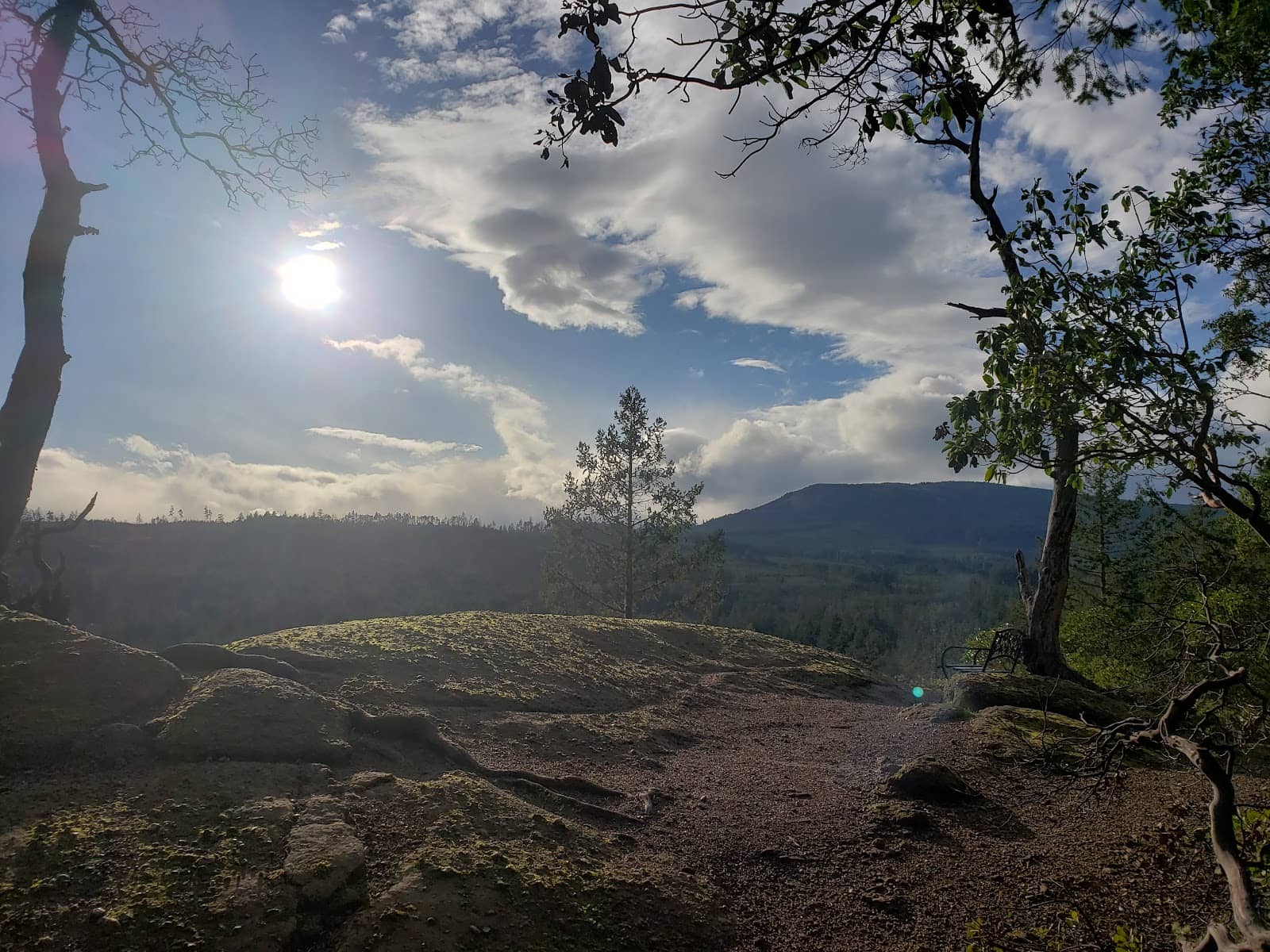
The Abyss Trail
Extension Ridge
A moderate 2-hour hike with under 200m vertical, leading to a stunning water overlook. Features moss, ferns, and unique geological formations.
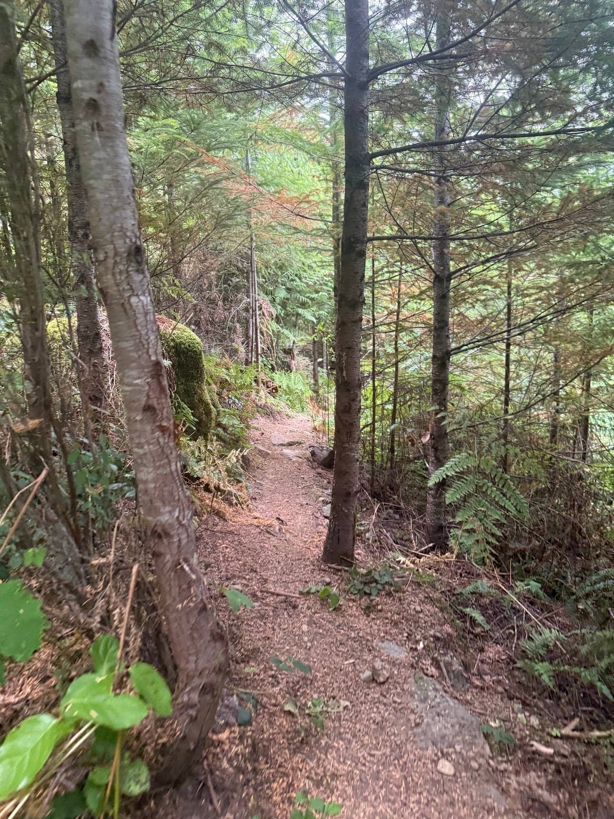
Extension Ridge Main Trails
Extension Ridge
Explore a system of well-maintained paths offering scenic views and varied terrain, suitable for hiking and mountain biking.
Geological Formations
The Abyss Trail
Discover fascinating rock formations and lush greenery along the return section of The Abyss trail, creating a unique natural spectacle.
Plans like a pro.
Thinks like you
Planning Your Visit
Trail Conditions & Maps
Parking & Access
Best Times
Insider Tips
from TikTok, Instagram & Reddit
Carry a Map 🗺️
Essential for navigating the extensive trail system. AllTrails is a popular choice among hikers.
Be Prepared for Terrain 🥺
Trails vary from easy to moderate with ups, downs, and twists. Not ideal for long-distance stamina training.
Watch for Litter 🚮
Unfortunately, some areas experience littering. Pack out what you pack in to help preserve the beauty.
Parking Challenges 🚗
Parking can be scarce; be prepared to park on the side of logging roads if necessary.
Tips
from all over the internet
Carry a Map 🗺️
Essential for navigating the extensive trail system. AllTrails is a popular choice among hikers.
Be Prepared for Terrain 🥺
Trails vary from easy to moderate with ups, downs, and twists. Not ideal for long-distance stamina training.
Watch for Litter 🚮
Unfortunately, some areas experience littering. Pack out what you pack in to help preserve the beauty.
Parking Challenges 🚗
Parking can be scarce; be prepared to park on the side of logging roads if necessary.
Good for Beginners 🤷♀️
Extension Ridge is recommended as an accessible trail for beginners.
What Travellers Say
Reviews Summary
Extension Ridge offers a diverse trail system with beautiful natural scenery, including unique geological formations and water overlooks. While many enjoy the accessible trails suitable for beginners and the scenic Abyss Trail, some visitors note issues with trail maintenance and limited parking, occasionally requiring parking on logging roads. Littering is also a concern in some areas.
"This is a great trailer system with lots of trails to choose from. Make sure you use a map such as All Trails however, be prepared for trails that have not been maintained or well used. We managed to walk close to 15 kms all around with lots of ups and downs as well some scenery."
Sheri Lucas
"Pretty trail that runs between Starks area to upper extension ridge. I’ve jogged it a few times but wouldn’t recommend if you’re training for stamina in long distance running cause it sure ain’t flat or easy LOL.
Lots of twists and turns, mostly trail, some gravel, moderate elevation gain - better suited for walking, hiking, mountain biking."
Lucy
"Beautiful, many trails off of the main trail. Upset about people littering , but thats some humans for ya."
Chaingun Charlie
What People Like
What People Dislike
Frequently Asked Questions
🚇 🗺️ Getting There
Access to Extension Ridge can involve parking on the side of logging roads due to limited designated parking. It's recommended to use a GPS or mapping app to find the most accessible trailheads.
While the main trail system is extensive, finding specific trailheads or parking can sometimes be challenging. Using a reliable map app like AllTrails is highly recommended.
Given the numerous trails and potential for unmaintained paths, using a map application like AllTrails is crucial for navigation and ensuring you stay on track.
Public transport options are generally limited for accessing trail systems like Extension Ridge. Driving is the most common method of arrival.
Logging roads can be rough and may require a vehicle with higher clearance. Be cautious when parking on the side of these roads.
🎫 🎫 Tickets & Entry
There are typically no entrance fees for Extension Ridge. It's a public access area for hiking and recreation.
Extension Ridge is generally accessible year-round during daylight hours. However, always check local conditions and advisories before visiting.
No advance booking is required for Extension Ridge. It's an open access area for public use.
Generally, no special permits are required for day hiking on Extension Ridge. However, always check for any local regulations or advisories.
While technically accessible, visiting Extension Ridge at night is not recommended due to potential navigation difficulties and safety concerns on unlit trails.
🎫 🥾 Onsite Experience
The Abyss trail is considered moderate, with under 200m of vertical gain over a 2-hour hike. It features ups, downs, and twists, making it not ideal for stamina training.
Expect a mix of well-maintained trails, some gravel paths, and natural beauty including moss, ferns, and interesting geological formations, especially on The Abyss trail.
Yes, Extension Ridge is recommended as an accessible trail system for beginners.
The Abyss trail leads to a lookout offering views over the water, providing a rewarding experience after a moderate hike.
Wear sturdy hiking shoes or boots due to varied terrain. Layers are recommended as weather can change, especially at higher elevations.
📸 📸 Photography
The Abyss trail offers scenic overlooks of the water and unique geological formations. The lush greenery and mossy areas also provide great photographic subjects.
Yes, the varied terrain, water views, and natural formations make Extension Ridge a good spot for landscape photography, especially during spring and autumn.
Morning light can be beautiful for capturing the lush greenery, while late afternoon can offer softer light for overlooks. Consider the direction of the sun for your desired shots.
Drone usage regulations can vary. It's essential to check local rules and regulations regarding drone operation in natural areas before flying.
The Abyss trail is frequently mentioned for its scenic overlook and interesting geological features, making it a prime spot for photography.


Social
from TikTok, Instagram & Reddit